| Main | Births etc |
|---|
| Balranald | |||||||
 The Sturt Highway at Balranald | |||||||

Balranald | |||||||
| Population: | 1,216 (2006 census) [1] | ||||||
| Established: | 1851 | ||||||
| Postcode: | 2715 | ||||||
| Coordinates: | Coordinates: | ||||||
| Elevation: | 61 m (200 ft) | ||||||
| Location: | |||||||
| LGA: | Balranald Shire Council | ||||||
| County: | Caira | ||||||
| State District: | Murray-Darling | ||||||
| Federal Division: | Farrer | ||||||
| |||||||
Balranald (![]() /bælˈrænəld/)[3] is a town and local government area (see Balranald Shire Council) in the Riverina district of New South Wales, Australia. At the 2006 census the population was 1,216.[1]
/bælˈrænəld/)[3] is a town and local government area (see Balranald Shire Council) in the Riverina district of New South Wales, Australia. At the 2006 census the population was 1,216.[1]
The town of Balranald is located where the Sturt Highway crosses the Murrumbidgee River in a remote, semi-desert area. Although it is part of New South Wales, Balranald receives Victorian television stations, with a range of Sydney and Melbourne newspapers available.
History[]
Balranald is located in Mutthi Mutthi Nations traditional country. The area has a long history before European settlement and a strong indigenous culture persists to this day.
Township beginnings[]


The former site of the wharves on the Murrumbidgee River
In about 1847–48 George James McDonald, the Commissioner for Crown Lands for the Lower Darling District, arrived at the site of the present-day township with a police escort. Commissioner McDonald had chosen the site as his base, and he and his entourage set up their camp under canvas. In 1848 Leighton Robinson and Thomas Duggan established a general store at Balranald and during the same year a public-house, the Balranald Inn, was erected by a Mr Robertson.
In 1849 the Crown Lands Commissioner McDonald recommended to the Colonial Secretary that a township be established at the location. McDonald was a Scotsman, born at Balranald on North Uist in the Outer Hebrides; he chose the name of his birth-place for the new settlement. He pointed out that the township’s position, on the lower reaches of the Murrumbidgee River, was expected to be of strategic importance with the impending introduction of steam navigation on the Murray.
During 1849 the surveyor Francis MacCabe laid out large reserves in the region of the Lower Murrumbidgee / Murray-Darling junction. Included in MacCabe's surveys was a site "for a Township at the North End of Caiera, otherwise Balranald Reserve". The decision to lay out Balranald township was made in November 1849. Commissioner McDonald died in 1851 and he was succeeded by Stephen Cole. Cole used Balranald as a base until 1853, when the office of Commissioner for Crown Lands for the Lower Darling District was transferred to Euston where a new house was erected for the Commissioner.[4]
The township of Balranald was gazetted on 4 April 1851 and the first land sale held on 14 January 1852, with thirty-five lots submitted to public auction. On 1 March 1852 an official post office opened in the township. (An earlier post office had opened in the area on 1 January 1850 but closed and was replaced by an unofficial service).[5] From 1853 the mail contractor, John Bent, operated a service along the Murrumbidgee River between Wagga Wagga and Balranald.[6]
A second hotel, the Carriers' Arms, was erected at Balranald in about 1852 by the German, Philipp Comitti (but records show he didn't arrive in Australia until Mar 1854). William Graham acquired the license of the Balranald Inn in April 1854. Graham held the license until 1859 when he was murdered. The perpetrator was arrested and later hanged at Goulburn gaol. Denis Hanan then obtained the license of the Balranald Inn, which he held until 1867. In 1859 Hanan purchased a punt from Captain Cadell and operated it at the southern end of Mayall Street.[7]
The Victorian gold-rushes, which began as Balranald was being established, had a profound impact on the Riverina region by stimulating the development of the fat-stock market. The development of the stock-route across the One-tree Plain to Lang’s Crossing-place tended to direct attention away from Balranald to the region up-river of the Murrumbidgee-Lachlan junction. By the latter half of the 1850s, when the fat-stock market was at its peak, Balranald was exhibiting signs of stagnation. A correspondent from the area made these comments about the township in August 1858: "This obscure and miserable township, situated on the Lower Murrumbidgee, is here attracting a considerable share of attention, as being one of those rowdy places for which the Australian bush in the interior has become so famous".[8]
Developments to 1900[]

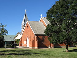
St Barnabas Anglican Church
Balranald became a major crossing place for stock from South Australia. In 1866 Peter Young built the Royal Hotel at Balranald and began operating a second punt at the township. A toll-house was later erected on the north bank of the river near Young's punt. William Hall purchased the Balranald Inn and the Mayall Street punt from Denis Hanan in 1867. The Commercial Hotel was erected in 1869 and the first licensee was John Russell. In 1871 a new Post & Telegraph Office was erected at Balranald, the first brick building to be built in the township.[7]
The first church to be built at Balranald was of the Anglican denomination; services began on 6 April 1873 by the incumbent minister Rev. W. H. Yarrington. Two months later the church was consecrated by the Bishop Mesac Thomas of the Diocese of Goulburn (of which Balranald was a part). A Roman Catholic church was completed in 1875. A newspaper, the Riverina Recorder, was commenced in 1877.
In 1881 the population of Balranald was about 400 and it was reported that the town supported five stores and six hotels. Balranald was proclaimed a Municipality in 1882 and Herman Levy was elected its first mayor. The first meetings of the Municipal Council were held in the old Court house at the corner of Market and River streets. A lift-span bridge was constructed over the Murrumbidgee River at Balranald, which opened in April 1883. In 1885 a new Court House was erected in the town. In 1887 Balranald was described as "a squarely built little town with few prominent buildings'. By that stage it had two churches and a Gospel Hall, a hospital, a branch of the Australian Joint Stock bank, and a Masonic Hall. By 1888 a Presbyterian church had been built there.[9]
1901 to the present[]


The Shamrock Hotel
The first public telephone service in Balranald was installed in 1911. The Balranald Municipal Council underwent financial difficulties, and in 1912 the NSW Government appointed a Receiver to take charge of affairs. The difficulties seem to have been overcome by the following year.
In March 1926 Balranald was connected to the Victorian Rail system via a line to Echuca. The railway line is now closed.
In 1956 the local government administrative body became the Shire of Balranald, with Shire Presidents replacing Mayoral positions.
New premises for the Balranald Shire Council were opened in August 1964. They were erected at a cost of £40,000 and are located in Market Street beside the Police Station.[7]
Burke and Wills[]
The Burke and Wills expedition crossed the Murrumbidgee River at Balranald on their journey to cross Australia from Melbourne to the Gulf of Carpentaria. The camels and two of the wagons crossed on the Mayall Street punt on Saturday, 15 September 1860, and the remaining waggons were brought over the next day. Camp XX was set up on the outskirts of Balranald (their twentieth camp since leaving Melbourne).
In order to lighten the loads on the wagons in preparation for crossing the mallee country between the Murrumbidgee and the Darling, Burke left 15+12⁄{{{4}}} long cwt (790 kg) of sugar, some rice, all eight demi-johns of lime juice, four bags of camel’s sugar, the anvil, bellows, some iron, the blacksmith’s vice, a handsaw, five axes, two rifles, several revolvers and the camel litter at Messrs Sparkes, Cramsie & Co.'s store. He then took on hay and maize for the animals and flour for the men, for which he paid very high prices. Three of the men were dismissed at Balranald and returned to Melbourne, where one of the men, Charles Ferguson, successfully sued the Royal Society of Victoria for wrongful dismissal.
On Monday, 17 September 1860 the expedition departed northwards for Paika Station.
Climate[]
Climate records have been kept for Balranald since 1879.[10] Temperature extremes are quite marked over the full year: the average maximum temperature in January is 33.0 °C (91.4 °F) and the average minimum temperature in July is 3.5 °C (38.3 °F).[10] The highest temperature recorded at Balranald was 47.7 °C (117.9 °F) in January 1908; the lowest recorded was −4.8 °C (23 °F) in July 1982. The average annual rainfall is 324.1 millimetres (12.8 in).[10]
| Climate data for Balranald RSL | |||||||||||||
|---|---|---|---|---|---|---|---|---|---|---|---|---|---|
| Month | Jan | Feb | Mar | Apr | May | Jun | Jul | Aug | Sep | Oct | Nov | Dec | Year |
| Record high °C (°F) | 47.7 (117.9) |
46.2 (115.2) |
42.2 (108.0) |
37.6 (99.7) |
35.6 (96.1) |
25.6 (78.1) |
27.0 (80.6) |
30.1 (86.2) |
36.7 (98.1) |
40.8 (105.4) |
43.3 (109.9) |
45.6 (114.1) |
47.7 (117.9) |
| Average high °C (°F) | 33.0 (91.4) |
32.5 (90.5) |
29.2 (84.6) |
24.0 (75.2) |
19.4 (66.9) |
16.1 (61.0) |
15.7 (60.3) |
17.6 (63.7) |
20.9 (69.6) |
24.5 (76.1) |
28.1 (82.6) |
30.9 (87.6) |
24.3 (75.7) |
| Average low °C (°F) | 16.4 (61.5) |
16.3 (61.3) |
13.6 (56.5) |
9.5 (49.1) |
6.8 (44.2) |
4.4 (39.9) |
3.5 (38.3) |
4.7 (40.5) |
7.1 (44.8) |
9.8 (49.6) |
12.6 (54.7) |
14.7 (58.5) |
10.0 (50.0) |
| Record low °C (°F) | 7.5 (45.5) |
7.2 (45.0) |
0.6 (33.1) |
0.8 (33.4) |
−3 (26.6) |
−3.3 (26.1) |
−4.8 (23.4) |
−2.4 (27.7) |
−2.2 (28.0) |
−3.9 (25.0) |
3.5 (38.3) |
5.5 (41.9) |
−4.8 (23.4) |
| Precipitation mm (inches) | 22.5 (0.886) |
25.3 (0.996) |
22.1 (0.87) |
23.4 (0.921) |
31.5 (1.24) |
29.8 (1.173) |
26.4 (1.039) |
29.7 (1.169) |
29.4 (1.157) |
31.1 (1.224) |
27.8 (1.094) |
25.2 (0.992) |
324.1 (12.76) |
| Avg. rainy days | 3.0 | 2.9 | 3.5 | 4.0 | 6.2 | 7.4 | 8.0 | 7.9 | 6.7 | 5.9 | 4.6 | 3.9 | 64.0 |
| Source: [10] | |||||||||||||
Agriculture[]
Agricultural activities in the Balranald district include sheep farming, woodcutting, charcoal production and some areas of irrigated crop-growing along the rivers.
Attractions[]
Balranald Shire is the location of Yanga National Park and World Heritage listed Mungo National Park.
Community[]
The town has an Australian rules football team competing in the Central Murray Football League.[11]
Golfers play at the Balranald Golf and Sporting Club on O'Conner Street.[12]
Australia's first telephone[]
The first telephone to be used in Australia was installed at nearby "Yanga" station, in order to allow communications between the homestead and the shearers' quarters. The installation was carried out by James Cromyn under directions forwarded from England by his uncle Alexander Graham Bell, an early developer of the telephone.[13]
The Balranald telephone exchange was converted from manual to automatic operation in 1989 and 1990. The manual exchange number prior to automation phone number was (050) 4841 to reach the exchange, then the numbers (050)201-000 to 201-999 were allocated for Balranald subscribers. Following the ACA renumbering in the late 1990s, the numbers are now in the (03)5020-1000 to (03)5020-1999 range.
References[]
- ^ a b Australian Bureau of Statistics (25 October 2007). "Balranald (Urban Centre/Locality)". 2006 Census QuickStats. http://www.censusdata.abs.gov.au/ABSNavigation/prenav/LocationSearch?collection=Census&period=2006&areacode=UCL103400&producttype=QuickStats&breadcrumb=PL&action=401. Retrieved 9 June 2009.
- ^ Travelmate
- ^ Macquarie Dictionary, Fourth Edition (2005). Melbourne, The Macquarie Library Pty Ltd. ISBN 1-876429-14-3
- ^ Feldtmann, Arthur, The Balranald Story, 1976 (a souvenir of the 'Back to Balranald' celebration - 28 September to 5 October 1976).
- ^ Premier Postal History, Post Office List, https://www.premierpostal.com/cgi-bin/wsProd.sh/Viewpocdwrapper.p?SortBy=VIC&country=, retrieved 2008-04-11
- ^ Jervis, James, 'The Western Riverina: A History of Its Development', Royal Australian Historical Society Journal and Proceedings, Vol. XXXVIII 1952, pp. 138-40; Feldtmann, op. cit.
- ^ a b c Feldtmann, op. cit.
- ^ Lower Murrumbidgee correspondent, Sydney Morning Herald, 23 August 1858.
- ^ Feldtmann, op. cit.; Jervis, op. cit.
- ^ a b c d "Balranald RSL climate averages". Bureau of Meteorology. Commonwealth of Australia. 1 June 2011. http://www.bom.gov.au/climate/averages/tables/cw_049002_All.shtml. Retrieved 5 June 2011.
- ^ Full Points Footy, Balranald, http://www.fullpointsfooty.net/Balranald.htm, retrieved 2008-07-25
- ^ Golf Select, Balranald, http://www.golfselect.com.au/armchair/courseView.aspx?course_id=916, retrieved 2009-05-11
- ^ Feldtmann, Arthur, The Balranald Story, 1976 (a souvenir of the 'Back to Balranald' celebration - 28 September to 5 October 1976), p. 29.
External links[]
 Media related to Balranald, New South Wales at Wikimedia Commons
- Balranald
- Burke & Wills Web A comprehensive website containing many of the historical documents relating to the Burke & Wills Expedition.
- The Burke & Wills Historical Society The Burke & Wills Historical Society.
- Balranald Railway Station
| ||||||||||||||||||||
| This page uses content from the English language Wikipedia. The original content was at Balranald. The list of authors can be seen in the page history. As with this Familypedia wiki, the content of Wikipedia is available under the Creative Commons License. |