| Main | Births etc |
|---|
| English: (British English) British Isles English: (Hiberno English) Ireland and Britain French: Îles Britanniques Irish: Éire agus an Bhreatain Mhór[1] or Oileáin Iarthair Eorpa[2] Manx: Ny h-Ellanyn Goaldagh[3] Scottish Gaelic: Eileanan Bhreatainn[4] Welsh: Ynysoedd Prydain[5] | |
|---|---|
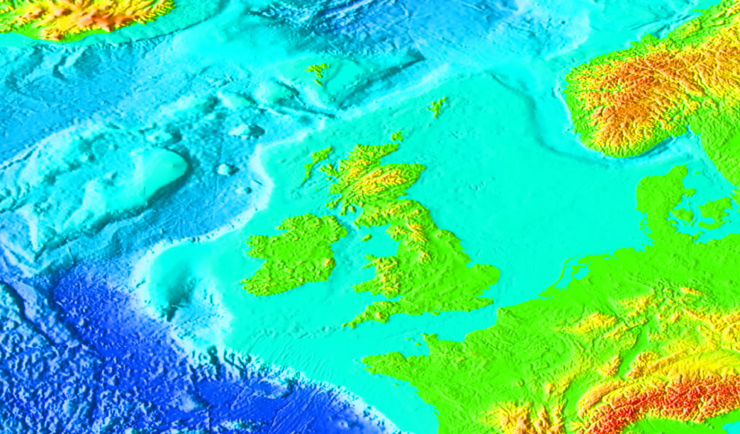
 Satellite image of the British Isles, excluding Orkney (southern part obscured by cloud, northern part out of frame) and Shetland (out of frame). | |
 | |
| Geography | |
| Location | Western Europe |
| Coordinates | |
| Total islands | 6,000+ |
| Major islands | Great Britain and Ireland |
| Area | 315,134 km2 (121,673.9 sq mi) |
| Highest elevation | 1,344 m (4,409 ft) |
| Highest point | Ben Nevis |
| Sovereign states and Crown Dependencies | |
| Largest city | Dublin |
| Largest city | London |
| Largest city | Douglas |
| Largest city | Saint Helier |
| Largest city | Saint Peter Port |
| Demographics | |
| Population | ~65 million |
| Ethnic groups | British, Channel Islanders, Cornish,[6] English, English Gypsies, Irish, Irish Travellers, Kale, Manx, Scottish, Ulster-Scots, Welsh |
The British Isles are a group of islands off the northwest coast of continental Europe that include the islands of Great Britain and Ireland and over six thousand smaller isles.[7] There are two sovereign states located on the islands: the United Kingdom of Great Britain and Northern Ireland (commonly known as the United Kingdom) and Ireland (also described as the Republic of Ireland).[8] The British Isles also include three dependencies of the British Crown: the Isle of Man and, by tradition, the Bailiwick of Jersey and the Bailiwick of Guernsey in the Channel Islands, although the latter are not physically a part of the archipelago.[9][10]
The oldest rocks in the group are in the north west of Scotland and Ireland and are 2,700 million years old. During the Silurian period the north-western regions collided with the south-east, which had been part of a separate continental landmass. The topography of the islands is modest in scale by global standards. Ben Nevis rises to an elevation of only 1,344 metres (4,409 ft) and Lough Neagh, which is notably larger than other lakes on the isles, covers only 381 square kilometres (147 sq mi). The climate is temperate marine, with mild winters and warm wet summers. The North Atlantic Drift brings significant moisture and raises temperatures 11 °C (20 °F) above the global average for the latitude. This led to a landscape which was long dominated by temperate rainforest, although human activity has since cleared the vast majority of forest cover. The region was re-inhabited after the last glacial period of Quaternary glaciation, by 12,000 BC in Great Britain and 8000 BC in Ireland. At that time, Great Britain was a peninsula of the European continent from which Ireland had become separated to form an island.
Scoti (Ireland), Pictish (northern Britain) and Brythons (southern Britain) tribes inhabited the islands at the beginning of the 1st millennium AD. Much of Brythonic-controlled Britain was conquered by the Roman Empire from AD 43. The first Anglo-Saxons arrived as Roman power waned in the 5th century and eventually dominating the bulk of what is now England.[11] Viking invasions began in the 9th century, followed by more permanent settlements and political change – particularly in England. The subsequent Norman conquest of England in 1066 and the later Angevin partial conquest of Ireland from 1169 led to the imposition of a new Norman ruling elite across much of Britain and parts of Ireland. By the Late Middle Ages, Great Britain was separated into the Kingdoms of England and Scotland, while control in Ireland fluxed between Gaelic kingdoms, Hiberno-Norman lords and the English-dominated Lordship of Ireland, soon restricted only to The Pale. The 1603 Union of the Crowns, Acts of Union 1707 and Acts of Union 1800 attempted to consolidate Britain and Ireland into a single political unit, the United Kingdom, with the Isle of Man and the Channel Islands remaining as Crown Dependencies. The expansion of the British Empire and migrations following the Irish Famine and Highland Clearances resulted in the distribution of the islands' population and culture throughout the world and a rapid de-population of Ireland in the second half of the 19th century. Most of Ireland seceded from the United Kingdom after the Irish War of Independence and the subsequent Anglo-Irish Treaty (1919–1922), with six counties remaining in the UK as Northern Ireland.
The term British Isles is controversial in Ireland,[7][12] where there are objections to its usage due to the association of the word British with Ireland.[13] The Government of Ireland does not use the term[14] and its embassy in London discourages its use.[15] As a result, Britain and Ireland is becoming a preferred description,[13][16][17] and Atlantic Archipelago is increasingly favoured in academia,[18][19][20][21] although British Isles is still commonly employed.[16] Equally controversial in Ireland are such attempts by Irish Nationalists to disassociate Ireland from the word "British" - many Irish people (particularly, but not restricted to, Irish Unionists) see this as politicising a geographical and cultural region, by attempting to downplay or undermine the emphatic geographic closeness of the archipelago and any common cultural and historical traits shared within it.
Etymology[]
The earliest known references to the islands as a group appeared in the writings of sea-farers from the ancient Greek colony of Massalia.[22][23] The original records have been lost; however, later writings that quoted from the Massaliote Periplus (6th century BC) and Pytheas's On the Ocean (circa 325–320 BC)[24] have survived. In the 1st century BC, Diodorus used the Latin form, Πρεττανία (Prettania) from Πρεττανική (Prettanike),[23] Strabo used Βρεττανία (Brettania), and Marcian of Heraclea, in his Periplus maris exteri, used αἱ Πρεττανικαί νῆσοι (the Prettanic Isles) to refer to the islands. Historians today, though not in absolute agreement, largely agree that these Greek and Latin names were probably drawn from native Celtic-language names for the archipelago.[25] Along these lines, the inhabits of the islands of Pretanike were called the Πρεττανοί (Priteni or Pretani).[23][26] The shift from the "P" of Pretannia to the "B" of Britannia by the Romans occurred during the time of Julius Caesar.[27]
The classical writer, Ptolemy, referred to the larger island as Great Britain (Megale Britannia) and to Ireland as Little Britain (Mikra Brettania) in his work, Almagest (147–148 AD). In his later work, Geography (c. 150 AD), he gave these islands the names Albion, Iwernia, and Mona (the Isle of Man), suggesting these may have been native names of the individual islands not known to him at the time of writing Almagest.[28] The name Albion appears to have fallen out of use sometime after the Roman conquest of Great Britain, after which Britain became the more common-place name for the island called Great Britain. Great Britain would return to use a millennium later, in the Middle Ages. At that time, it was used to distinguish the island of Britain from the peninsula of Brittany, in northern-western France that had been settled by Britons, which was confusingly similar to the medieval writers. Great Britain and Britain later became synonymous with the Kingdom of Great Britain and the United Kingdom.
The earliest known use of the phrase Brytish Iles in the English language is dated 1577 in a work by John Dee.[29] Today, this name is seen by some as carrying imperialist overtones[16] although it is still commonly used. Other names used to describe the islands aside from British Isles, include the Anglo-Celtic Isles,[30][31] British-Irish Isles,[32] Britain and Ireland, UK and Ireland, and British Isles and Ireland.[33] Owing to political and national associations with the word British, the Government of Ireland does not use the term British Isles [14] and its embassy in London discourages its use.[34] In documents drawn up jointly between the British and Irish governments, the archipelago is referred to simply as "these islands".[35]
Some publishers' style guides, such as the Economic History Society's and the Guardian newspaper's, suggest that use of the term British Isles should be avoided[36] and, in early 2008, it was reported that National Geographic said it would use the wording British and Irish Isles instead.[37] In 2006, Folens, an Irish publisher of school text books, decided to stop using the term in Ireland[38][39] and in 2001 the rugby union team the British Isles (or British Lions) was renamed the British and Irish Lions.
Geography[]
The British Isles in relation to the north-west European continental shelf.
The British Isles lie at the juncture of several regions with past episodes of tectonic mountain building. These orogenic belts form a complex geology which records a huge and varied span of earth history.[40] Of particular note was the Caledonian Orogeny during the Ordovician Period, c. 488–444 Ma and early Silurian period, when the craton Baltica collided with the terrane Avalonia to form the mountains and hills in northern Britain and Ireland. Baltica formed roughly the north western half of Ireland and Scotland. Further collisions caused the Variscan orogeny in the Devonian and Carboniferous periods, forming the hills of Munster, south-west England, and south Wales. Over the last 500 million years the land which forms the islands has drifted northwest from around 30°S, crossing the equator around 370 million years ago to reach its present northern latitude.[41]
The islands have been shaped by numerous glaciations during the Quaternary Period, the most recent being the Devensian. As this ended, the central Irish Sea was de-glaciated and the English Channel flooded, with sea levels rising to current levels some 4,000 to 5,000 years ago, leaving the British Isles in their current form. Whether or not there was a land bridge between Great Britain and Ireland at this time is somewhat disputed, though there was certainly a single ice sheet covering the entire sea.
The islands' geology is highly complex, though there are large numbers of limestone and chalk rocks that formed in the Permian and Triassic periods. The west coasts of Ireland and northern Great Britain that directly face the Atlantic Ocean are generally characterised by long peninsulas, and headlands and bays; the internal and eastern coasts are "smoother".
There are about 136 permanently inhabited islands in the group, the largest two being Great Britain and Ireland. Great Britain is to the east and covers 216,777 km2 (83,698 square miles), over half of the total landmass of the group. Ireland is to the west and covers 84,406 km2 (32,589 square miles). The largest of the other islands are to be found in the Hebrides, Orkney and Shetland to the north, Anglesey and the Isle of Man between Great Britain and Ireland, and the Channel Islands near the coast of France.
The islands are at relatively low altitudes, with central Ireland and southern Great Britain particularly low lying: the lowest point in the islands is Holme, Cambridgeshire at −2.75 m (−9.02 ft).[42] The Scottish Highlands in the northern part of Great Britain are mountainous, with Ben Nevis being the highest point on the islands at 1,343 m (4,406 ft).[43] Other mountainous areas include Wales and parts of Ireland, however only seven peaks in these areas reach above 1,000 m (3,281 ft). Lakes on the islands are generally not large, although Lough Neagh in Northern Ireland is an exception, covering 381 square kilometres (147 sq mi). The largest freshwater body in Great Britain is Loch Lomond at 71.1 square kilometres (27 sq mi). There are a number of major rivers within the British Isles. The river Severn at 354 km (220 mi) is the longest in Great Britain and the Shannon at 386 km (240 mi) is the longest in Ireland. The isles have a temperate marine climate. The North Atlantic Drift ("Gulf Stream") which flows from the Gulf of Mexico brings with it significant moisture and raises temperatures 11 °C (20 °F) above the global average for the islands' latitudes.[44] Winters are cool and wet, with summers mild and also wet. Most Atlantic depressions pass to the north of the islands, combined with the general westerly circulation and interactions with the landmass, this imposes an east-west variation in climate.[45]
Flora and fauna[]


Some female red deer in Killarney National Park, Ireland.
The islands enjoy a mild climate and varied soils, giving rise to a diverse pattern of vegetation. Animal and plant life in the archipelago is similar to that of the northwestern European continent. However, there are few numbers of species with Ireland having even less. All native flora and fauna in Ireland, for example, is made up of species that migrated from the elsewhere in Europe, and Great Britain in particular. However, the only window during which this could occur was between the end of the last Ice Age (about 12,000 years ago) and when the land bridge connecting the two islands was flooded by sea (about 8,000 years ago).
Originally forests covered all parts of the islands but today only account for about 9% of the land area of Great Britain and 5% of Ireland. These forests were cleared extensively over the past millennium to make way for crop and pasture land. Most forest land in Ireland are maintained by state forestation programmes. Almost all land outside of urban areas is farmland. However, relatively large areas of forest remain in east and north Scotland and in southeast England. Oak, elm, ash and beech are amongst the most common trees in England. In Scotland, pine and birch are most common. Natural forests in Ireland are mainly oak, ash, wych elm, birch and pine. Beech and lime, though not native to Ireland, are also common there. Farmland hosts a variety of semi-natural vegetation of grasses and flowering plants. Woods, hedgerows, mountain slopes and marshes host heather, wild grasses, gorse and bracken.
Larger animals, such as wolf, bear and reindeer are today extinct. However, some species such as red deer are protected. Other small mammals, such as foxes, badgers, hares, hedgehogs, and stoats, are very common. Many rivers contain otters and seals are common on coasts. Over 200 species of bird reside permanently on the islands and another 200 migrate to them. Common types are the chaffinch, blackbird, sparrow and starling, all small birds. Large birds are declining in number, except for those kept for game such as pheasant, partridge, and red grouse. Fish are abundant in the rivers and lakes of the islands, in particular salmon, trout, perch and pike. Dogfish, cod, sole, pollock and bass are among the sea fish as well as mussels, crab and oysters on the coastline. There are more than 21,000 species of insects found on the islands.
Neither Great Britain nor Ireland are inhabited by many reptiles or amphibians. Only three snakes are native to Great Britain: the common European adder, the grass snake and the smooth snake;[46] none are native to Ireland. In general, Great Britain has slightly more variation and native wild life, with weasels, polecats, wildcats, most shrews, moles, the water voles, roe deer and common toads also being absent in Ireland. This patterns in true also for birds and insects. However, notable reversals of this theme include the Kerry slug and certain species of wood lice, which are native to Ireland but not found on Great Britain.
Domestic animals native to the islands include the Connemara pony, Shetland pony, Irish wolfhound and several types of cattle and sheep.
Demographics[]

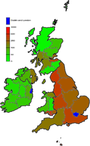
Population density per km² of the British Isles' regions. London and Dublin, with respective population densities of 4,761 and 1,288 are shaded blue.
The demographics of the British Isles today are characterised by a generally high density of population in England, which accounts for almost 80% of the total population of the islands. In elsewhere on Great Britain and on Ireland, high density of population is limited to areas around, or close to, a few large cities. The largest urban area by far is the London metropolitan area with 12–14 million inhabitants. Other major populations centres include Greater Manchester Urban Area (2.5 million), West Midlands conurbation (2.3 million), West Yorkshire Urban Area (2.1 million) in England, Greater Glasgow (1.7 million) in Scotland and Greater Dublin Area (1.6 million) in Ireland.
The population of England rose rapidly during the 19th and 20th centuries whereas the populations of Scotland and Wales have shown little increase during the 20th century, with the population of Scotland remaining unchanged since 1951. Ireland for most of its history comprised a population proportionate to its land area (about one third of the total population). However, since the Great Irish Famine, the population of Ireland has fallen to less than one tenth of the population of the British Isles. The famine, which caused a century-long population decline, drastically reduced the Irish population and permanently altered the demographic make-up of the British Isles. On a global scale, this disaster led to the creation of an Irish diaspora that numbers fifteen times the current population of the island.
The linguistic heritage of the British Isles is rich,[47] with twelve languages from six groups across four branches of the Indo-European family. The Insular Celtic languages of the Goidelic sub-group (Irish, Manx and Scottish Gaelic) and the Brythonic sub-group (Cornish, Welsh and Breton, spoken in north-western France) are the only remaining Celtic languages – the last of their continental relations becoming extinct before the 7th century.[48] The Norman languages of Guernésiais, Jèrriais and Sarkese spoken in the Channel Islands are similar to French. A cant, called Shelta, is a language spoken by Irish Travellers, often as a means to conceal meaning from those outside the group.[49] However, English, sometimes in the form of Scots, is the dominant language, with few monoglots remaining in the other languages of the region.[50] The Norn language of Orkney and Shetland became extinct around 1880.[51]
Government[]

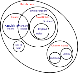
Euler diagram of states and government in the British Isles
There are two sovereign states in the isles: Ireland and the United Kingdom of Great Britain and Northern Ireland. Ireland, sometimes called the Republic of Ireland, governs five sixths of the island of Ireland, with the remainder of the island forming Northern Ireland. Northern Ireland is a part of the United Kingdom of Great Britain and Northern Ireland, usually shortened to simply the United Kingdom, which governs the remainder of the archipelago with the exception of the Isle of Man and the Channel Islands. The Isle of Man and the two states of the Channel Islands, the Jersey and the Guernsey, are known as the Crown Dependencies. They exercise constitutional rights of self-government and judicial independence;[52] responsibility for international representation rests largely upon the UK (in consultation with the respective governments); and responsibility for defence is reserved by the UK. The United Kingdom is made up of four constituent parts: England, Scotland and Wales, forming Great Britain, and Northern Ireland in the north-east of the island of Ireland. Of these, Scotland, Wales and Northern Ireland have "devolved" governments meaning that they have their own parliaments/assemblies and are self-governing with respect to certain areas set down by law. For judicial purposes, Scotland, Northern Ireland and England and Wales (the latter being one entity) form separate legal jurisdiction, with there being no single law for the UK as a whole.
All of the states in the isles are parliamentary democracies with their own separate parliaments. All parts of the United Kingdom return members to parliament in London. In addition to this, voters in Scotland, Wales and Northern Ireland return members to a parliament in Edinburgh and to assemblies in Cardiff and Belfast respectively. Governance in the norm is by majority rule, however, Northern Ireland uses a system of power sharing whereby unionists and nationalists share executive posts proportionately and where the assent of both groups are required for the Northern Ireland Assembly to make certain decisions. (In the context of Northern Ireland, unionists are those who want Northern Ireland to remain a part of the United Kingdom and nationalists are those who want Northern Ireland join with the rest of Ireland.) The British monarch is the head of state for all parts of the isles except for the Republic of Ireland, where the head of state is the President of Ireland.
Ireland and the United Kingdom are part of the European Union (EU). The Crown Dependencies are not a part of the European Union but have certain limited privileges and obligations that were negotiated as a part of the UK's accession to the EU.[52][53][54] Neither the United Kingdom or Ireland area part of the Schengen area, that allow passport-free travel between EU members states. However, since the partition of Ireland, an informal free-travel area had existed across the region. In 1997, this area required formal recognition during the course of negotiations for the Amsterdam Treaty of the European Union and is now known as the Common Travel Area.
Reciprocal arrangements allow British and Irish citizens to full voting rights in the two states. Exceptions to this are presidential elections and constitutional referendums in the Republic of Ireland, for which there is no comparable franchise in the other states. In the United Kingdom, these pre-date European Union law, and in both jurisdictions go further than that required by European Union law. Other EU nationals may only vote in local and European Parliament elections while resident in either the UK or Ireland. In 2008, a UK Ministry of Justice report investigating how to strengthen the British sense of citizenship proposed to end this arrangement arguing that, "the right to vote is one of the hallmarks of the political status of citizens; it is not a means of expressing closeness between countries."[55]
The Northern Ireland Peace Process has led to a number of unusual arrangements between the Republic of Ireland, Northern Ireland and the United Kingdom. For example, citizens of Northern Ireland are entitled to the choice of Irish or British citizenship or both and the Governments of Ireland and the United Kingdom consult on matters not devolved to the Northern Ireland Executive. The Northern Ireland Executive and the Government of Ireland also meet as the North/South Ministerial Council to develop policies common across the island of Ireland.
These arrangements were made following the 1998 Belfast Agreement. Another body established under that agreement, the British-Irish Council, is made up of the major political entities governing the islands. The British-Irish Inter-Parliamentary Body (Irish: Comhlacht Idir-Pharlaiminteach na Breataine agus na hÉireann) predates the British-Irish Council and was established in 1990. Originally it comprised 25 members of the Oireachtas, the Irish parliament, and 25 members of the parliament of the United Kingdom, with the purpose of building mutual understanding between members of both legislature. Since then the role and scope of the body has been expanded to include representatives from the Scottish Parliament, the National Assembly for Wales, the Northern Ireland Assembly, the States of Jersey, the States of Guernsey and the High Court of Tynwald (Isle of Man).
The British-Irish Council does not have executive powers but meets biannually to discuss issues of mutual importance. Similarly, the British-Irish Inter-Parliamentary Body has no legislative powers but investigates and collects witness evidence from the public on matters of mutual concern to its members. Reports on its findings are presented to the Governments of Ireland and the United Kingdom. During the February 2008 meeting of the British-Irish Council, it was agreed to set up a standing secretariat that would serve as a permanent 'civil service' for the Council.[56] Leading on from developments in the British-Irish Council, the chair of the British-Irish Inter-Parliamentary, Niall Blaney, has suggested that the body should shadow the British-Irish Council's work.[57]
Many civil bodies are organised throughout the islands as a whole. For example the Samaritans, which is deliberately organised without regard to national boundaries on the basis that a service which is not political or religious should not recognise sectarian or political divisions. The RNLI, the life boats service, is also organised throughout the islands as a whole, covering both the United Kingdom and Ireland.[58]
History[]
At the end of the last ice age, what are now the British Isles were joined to the European mainland as a mass of land extending north west from the modern-day northern coastline of France, Belgium and the Netherlands. Ice covered almost all of what is now Ireland and Great Britain with the exception of most of modern-day Munster and much of what we now call England. Between 14,000 to 10,000 years ago, as the ice melted, sea levels rose separating Ireland from the mainland, creating also the Isle of Man. About two to four millennia later, Great Britain became separated from the mainland. Britain probably became repopulated with people before the ice age ended and certainly before it became separated from the mainland. It is likely that Ireland became settled by sea after it had already become an island.
At the time of the Roman Empire, about two thousand years ago, various tribes were inhabiting the islands. The Romans expanded their civilisation to control southern Great Britain but were impeded in advancing any further, building Hadrian's Wall to mark the northern frontier of their empire in 122 AD. At that time, Ireland was populated by a people known as Scots, the northern part of Great Britain by a people known as Picts and the southern half by Britons. Anglo-Saxons arrived as Roman power waned in the 5th century AD. Initially, their arrival seems to have been at the invitation of the Britons as mercenaries to repulse incursions by the Scots and Picts. In time, Anglo-Saxon demands on the British became so great that they came to culturally dominate the bulk of southern Great Britain, though recent genetic evidence suggests Britons still formed the bulk of the population. This dominance creating what is now England and leaving culturally British enclaves only in the north of what is now England, in Cornwall and what is now known as Wales. Ireland had been unaffected by the Romans except, significantly, having been Christianised, traditionally by the Romano-Brition, Saint Patrick. As Europe, including Britain descended turmoil following in the collapse of Roman civilisation, an era known as the Dark Ages, Ireland entering a golden age and responded with missions, first to Great Britain and then to the continent, founding monasteries and universities and were later joined by Anglo-Saxon missions of the same nature.
Viking invasions began in the 9th century, followed by more permanent settlements, particularly along the east coast of Ireland, the west coast of modern-day Scotland and the Isle of Man. Though the Vikings were eventually neutralised in Ireland, their influence remained in the cities of Dublin, Cork, Limerick, Waterford and Wexford. England however was slowly conquered around the turn of the first millennium AD, eventually become feudal possession of the Kingdom of Denmark. The relations between the descendants of Vikings in England and counterparts in Normandy, in northern France, lay at the heart of a series of events that led to the Norman conquest of England in 1066. The remnants of the Duchy of Normandy, which conquered England, remain associated to the English Crown as the Channel Islands to this day. A century later the marriage of the future Henry II of England to Eleanor of Aquitaine created the Angevin Empire, partially under the French Crown. At the invitation of a provincial king and under the authority of Pope Adrian IV (the only Englishman to be elected pope), the Angevins invaded Ireland in 1169. Though initially intended to be kept as an independent kingdom, the failure of the Irish High King to ensure the terms of the Treaty of Windsor led Henry II, as King of England, to rule as effective monarch under the title of Lord of Ireland. This title was granted to his younger son but when Henry's heir unexpectedly died the title of King of England and Lord of Ireland became entwined in one person.
By the Late Middle Ages, Great Britain was separated into the Kingdoms of England and Scotland. Power in Ireland fluxed between Gaelic kingdoms, Hiberno-Norman lords and the English-dominated Lordship of Ireland. A similar situation existed in the Principality of Wales, which was slowly being annexed into the Kingdom of England by a series of laws. During the course of the 15th century, the Crown of England would assert a claim to the Crown of France, thereby also releasing the King of England as from being vassal of the King of France. In 1534, King Henry VIII, at first having been a strong defender of Roman Catholicism in the face of the Reformation, separated from the Roman Church after failing to secure a divorce from the Pope. His response was to place the King of England as "the only Supreme Head in Earth of the Church of England", thereby removing the authority of the Pope from the affairs of the English Church. Ireland, which had been held by the King of England as Lord of Ireland, but which strictly speaking had been a feudal possession of the Pope since the Norman invasion invasion was declared a separate kingdom in personal union with England.
Scotland, meanwhile had remained an independent Kingdom. In 1603, that changed when the King of Scotland inherited the Crown of England, and consequently the Crown of Ireland also. The subsequent 17th century was one of political upheaval, religious division and war. English colonialism in Ireland of the 16th century was extended by large-scale Scottish and English colonies in Ulster. Religious division heightened and the King in England came into conflict with parliament. A prime issue was, inter alia, over his policy of tolerance towards Catholicism. The resulting English Civil War or War of the Three Kingdoms led to a revolutionary republic in England. Ireland, largely Catholic was mainly loyal to the king. Following defeat to the parliaments army, large scale land distributions from loyalist Irish nobility to English commoners in the service of the parliamentary army created the beginnings a new Ascendancy class which over the next hundred years would obliterated the English (Hiberno-Norman) and Gaelic Irish nobility in Ireland. The new class was Protestant and British the common people were, largely Catholic and Irish. This theme would influence Irish politics for centuries to come. When the monarchy was restored in England, the king found it politically impossible to restore all the lands of former land-owners in Ireland. The "Glorious Revolution" of 1688 repeated similar themes: a Catholic king pushing for religious tolerance in opposition to a Protestant parliament in England. The king's army was defeated at the Battle of the Boyne and at the militarily crucial Battle of Aughrim in Ireland. Resistance held out, and a guarantee of religious tolerance was a cornerstone of the Treaty of Limerick. However, in the evolving political climate, the terms of Limerick were superseded, a new monarchy was installed, and the new Irish parliament was packed with the new elite which legislated increasing intolerant Penal Laws, which discommoded both Dissenters and Catholics.
The Kingdoms of England and Scotland were unified in 1707 creating the Kingdom of Great Britain. Following an attempted republican revolution in Ireland in 1798, the Kingdoms of Ireland and Great Britain were unified in 1801, creating the United Kingdom. The Isle of Man and the Channel Islands remaining outside of the United Kingdom but with their ultimate good governance being the responsibility of the British Crown (effectively the British government). Although, the colonies of North American that would become the United States of America were lost by the start of the 19th century, the British Empire expanded rapidly elsewhere. A century later it would cover one thirds of the globe. Poverty in Ireland remained desperate however and industrialisation in England led to terrible condition for the working class. Mass migrations following the Irish Famine and Highland Clearances resulted in the distribution of the islands' population and culture throughout the world and a rapid de-population of Ireland in the second-half of the 19th century. Most of Ireland seceded from the United Kingdom after the Irish War of Independence and the subsequent Anglo-Irish Treaty (1919–1922), with six counties that form Northern Ireland remaining as an autonomous region of the UK.
Culture[]


Pádraig Harrington teeing off at the Open Championship (golf) in 2007.
The United Kingdom and Ireland have separate media, although British television, newspapers and magazines are widely available in Ireland,[59] giving people in Ireland a high level of familiarity with cultural matters in Great Britain. A few cultural events are organised for the island group as a whole. For example, the Costa Book Awards are awarded to authors resident in the UK or Ireland. The Man Booker Prize is awarded to authors from the Commonwealth of Nations and Ireland. The Mercury Music Prize is handed out every year to the best album from a British or Irish musician or group.
Many globally popular sports had modern rules codified in the British Isles, including golf, association football, cricket, rugby, snooker and darts, as well as many minor sports such as croquet, bowls, pitch and putt, water polo and handball. A number of sports are popular throughout the British Isles, the most prominent of which is association football. While this is organised separately in different national associations, leagues and national teams, even within the UK, it is a common passion in all parts of the islands. Rugby union is also widely enjoyed across the islands. The British and Irish Lions is a team made up of players from England, Ireland, Scotland and Wales that undertakes tours of the southern hemisphere rugby playing nations every four years. This team was formerly known as the British Isles and the British Lions, but has been called the British and Irish Lions since 2001. Ireland play as a united team, represented by players from both Northern Ireland and the Republic. The four national rugby teams from Great Britain and Ireland play each other each year for the Triple Crown as part of the Six Nations Championship. Also since 2001 the professional club teams of Ireland, Scotland and Wales have competed together in the Magners League.
The Ryder Cup in golf was originally played between a United States team and a team representing Great Britain and Ireland. From 1979 onwards this was expanded to include the whole of Europe.
Transport[]

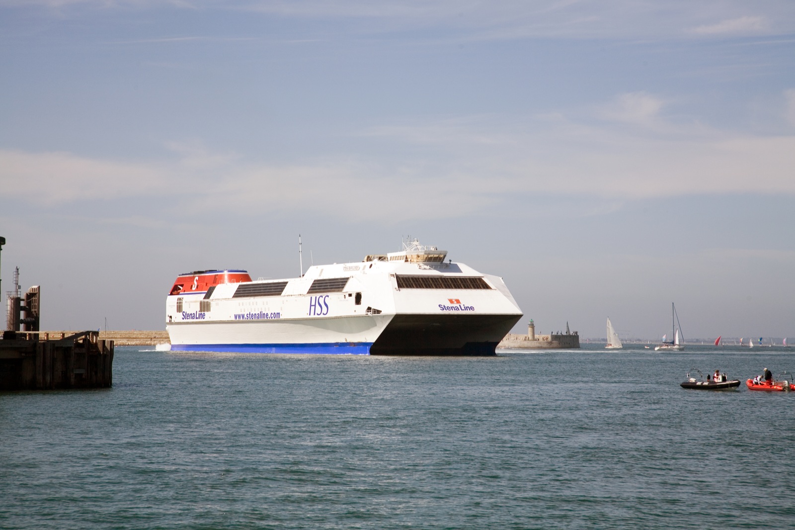
MS Stena Explorer, a large fast ferry operating the Holyhead–Dun Laoghaire route between Great Britain and Ireland.
London Heathrow Airport is Europe's busiest airport in terms of passenger traffic and the Dublin-London route is the busiest air route in Europe.[60] The English Channel and the southern North Sea are the busiest seaways in the world.[61] The Channel Tunnel, opened in 1994, links Great Britain to France and is the second-longest rail tunnel in the world.
The idea of building a tunnel under the Irish Sea has been raised since 1895,[62] when it was first investigated. Several potential Irish Sea tunnel projects have been proposed, most recently the Tusker Tunnel between the ports of Rosslare and Fishguard proposed by The Institute of Engineers of Ireland in 2004.[63] A rail tunnel was proposed in 1997 on a different route, between Dublin and Holyhead, by British engineering firm Symonds. Either tunnel, at 80 km (50 mi), would be by far the longest in the world, and would cost an estimated €20 billion. A proposal in 2007,[64] estimated the cost of building a bridge from County Antrim in Northern Ireland to Galloway in Scotland at £3.5bn (€5bn).
See also[]
- Extreme points of the British Isles
- British Islands
References[]
- ^ "British Isles". focal.ie Terminology Database. Foras na Gaeilge / Dublin City University. http://www.focal.ie/Search.aspx?term=the%20British%20Isles&lang=1. Retrieved 2010-09-23. "the British Isles s pl (Tíreolaíocht · Geography; Polaitíocht · Politics; Stair · History; Logainmneacha » Ceantar/Réigiún · Placenames » Area/Region) Éire bain agus an Bhreatain bain2 Mhór"
- ^ Dinneen, Patrick (1927), Foclóir Gaeilge Béarla, Irish-English Dictionary (2nd (1979 reprint) ed.), Dublin: The Educational Company of Ireland, p. 812, "Oileain [sic] Iarthair Eorpa, the British or West European Isles;"
- ^ Office of The President of Tynwald, http://www.tynwald.org.im/papers/press/2008/pr33.pdf
- ^ University of Glasgow Department of Celtic, http://www.gla.ac.uk/departments/celtic/duilleagangidhlig/
- ^ These are the official languages of the eight jurisdictions within the British Isles. Other languages are spoken, including several other native languages and dialects that have regional or special status.
- ^ Thernstrom, Stephan (1980), Harvard Encyclopedia of American Ethnic Groups, Cambridge, Massachusetts: Harvard University Press, p. 243, ISBN 0674375122, "Both geographic and historical factors distinguish the Cornish as an ethnic group."
- ^ a b "British Isles," Encyclopædia Britannica
- ^ The diplomatic and constitutional name of the Irish state is simply Ireland. For disambiguation purposes, Republic of Ireland is often used although technically not the name of the state but, according to the Republic of Ireland Act 1948, the state "may be described" as such.
- ^ Oxford English Dictionary: "British Isles: a geographical term for the islands comprising Great Britain and Ireland with all their offshore islands including the Isle of Man and the Channel Islands."
- ^ Alan, Lew; Colin, Hall; Dallen, Timothy (2008). World Geography of Travel and Tourism: A Regional Approach. Oxford: Elsevier. ISBN 9780750679787. "The British Isles comprise more than 6,000 islands off the northwest coast of continental Europe, including the countries of the United Kingdom of Great Britain (England, Scotland and Wales) and Northern Ireland, and the Republic of Ireland. The group also includes the United Kingdom crown dependencies of the Isle of Man, and by tradition, the Channel Islands (the Bailiwicks of Guernsey and Jersey), even though these islands are strictly speaking an archipelago immediately off the coast of Normandy (France) rather than part of the British Isles."
- ^ British Have Changed Little Since Ice Age, Gene Study SaysJames Owen for National Geographic News, July 19, 2005 [1]
- ^ Social work in the British Isles by Malcolm Payne, Steven Shardlow When we think about social work in the British Isles, a contentious term if ever there was one, what do we expect to see?
- ^ a b Davies, Alistair; Sinfield, Alan (2000), British Culture of the Postwar: An Introduction to Literature and Society, 1945-1999, Routledge, p. 9, ISBN 0415128110, "Some of the Irish dislike the 'British' in 'British Isles', while a minority of the Welsh and Scottish are not keen on 'Great Britain'. … In response to these difficulties, 'Britain and Ireland' is becoming preferred official usage if not in the vernacular, although there is a growing trend amongst some critics to refer to Britain and Ireland as 'the archipelago'."
- ^ a b "Written Answers - Official Terms", Dáil Éireann - Volume 606 - 28 September 2005. In his response, the Irish Minister for Foreign Affairs stated that "The British Isles is not an officially recognised term in any legal or inter-governmental sense. It is without any official status. The Government, including the Department of Foreign Affairs, does not use this term. Our officials in the Embassy of Ireland, London, continue to monitor the media in Britain for any abuse of the official terms as set out in the Constitution of Ireland and in legislation. These include the name of the State, the President, Taoiseach and others."
- ^ Sharrock, David (3 October 2006), "New atlas lets Ireland slip shackles of Britain", The Times (UK), http://www.timesonline.co.uk/tol/news/world/europe/article658099.ece, retrieved 7 July 2010, "A spokesman for the Irish Embassy in London said: “The British Isles has a dated ring to it, as if we are still part of the Empire. We are independent, we are not part of Britain, not even in geographical terms. We would discourage its useage [sic].”"
- ^ a b c Hazlett, Ian (2003). The Reformation in Britain and Ireland: an introduction. Continuum International Publishing Group. p. 17. ISBN 9780567082800. "At the outset, it should be stated that while the expression 'The British Isles' is evidently still commonly employed, its intermittent use throughout this work is only in the geographic sense, in so far as that is acceptable. Since the early twentieth century, that nomenclature has been regarded by some as increasingly less usable. It has been perceived as cloaking the idea of a 'greater England', or an extended south-eastern English imperium, under a common Crown since 1603 onwards. … Nowadays, however, 'Britain and Ireland' is the more favoured expression, though there are problems with that too. … There is no consensus on the matter, inevitably. It is unlikely that the ultimate in non-partisanship that has recently appeared the (East) 'Atlantic Archipelago' will have any appeal beyond captious scholars."
- ^ "Guardian Style Guide", Guardian, http://www.guardian.co.uk/styleguide/b, "A geographical term taken to mean Great Britain, Ireland and some or all of the adjacent islands such as Orkney, Shetland and the Isle of Man. The phrase is best avoided, given its (understandable) unpopularity in the Irish Republic. The plate in the National Geographic Atlas of the World once titled British Isles now reads Britain and Ireland."
- ^ Norquay, Glenda; Smyth, Gerry (2002), Across the margins: cultural identity and change in the Atlantic archipelago, Manchester University Press, p. 4, ISBN 0719057493, "The term we favour here – Atlantic Archipelago – may prove to be of no greater use in the long run, but at this stage it does at least have the merit of questioning the ideology underpinning more established nomenclature."
- ^ Schwyzer, Philip; Mealor, Simon (2004), Archipelagic identities: literature and identity in the Atlantic Archipelago, Ashgate Publishing, p. 10, ISBN 0754635848, "In some ways 'Atlantic Archipelago' is intended to do the work of including without excluding, and while it seems to have taken root in terms of academic conferences and publishing, I don't see it catching on in popular discourse or official political circles, at least not in a hurry."
- ^ Kumar, Krishan (2003), The Making of English National Identity, Cambridge University Press, p. 6, ISBN 0521777364, "Some scholars, seeking to avoid the political and ethnic connotations of 'the British Isles', have proposed the 'Atlantic Archipelago' or even 'the East Atlantic Archipelago' (see, e.g. Pocock 1975a: 606; 1995: 292n; Tompson, 1986) Not surprisingly this does not seem to have caught on with the general public, though it has found increasing favour with scholars promoting the new 'British History'."
- ^ Armitage, David; Braddick, Michael (2002), The British Atlantic world, 1500-1800, Palgrave Macmillan, p. 284, ISBN 0333963407, "British and Irish historians increasingly use 'Atlantic archipelago' as a less metro-centric term for what is popularly known as the British Isles."
- ^ Foster, p. 1.
- ^ a b c Allen, p. 172-174.
- ^ Harley, p. 150.
- ^ Davies, p. 47.
- ^ Snyder, p. 68.
- ^ Snyder, p. 12.
- ^ Freeman, Philip (2001). Ireland and the classical world. Austin, Texas: University of Texas Press. p. 65. ISBN 0-292-72518-3. http://books.google.com/books?id=ZSHhfOM-5AEC&pg=PA65.
- ^ John Dee, 1577. 1577 J. Arte Navigation, p. 65 "The syncere Intent, and faythfull Aduise, of Georgius Gemistus Pletho, was, I could..frame and shape very much of Gemistus those his two Greek Orations..for our Brytish Iles, and in better and more allowable manner." From the OED, s.v. "British Isles"
- ^ D. A. Coleman (1982), Demography of immigrants and minority groups in the United Kingdom: proceedings of the eighteenth annual symposium of the Eugenics Society, London 1981, Volume 1981, Academic Press, p. 213, ISBN 0121797805, "The geographical term British Isles is not generally acceptable in Ireland, the term these islands being widely used instead. I prefer the Anglo-Celtic Isles, or the North-West European Archipelago."
- ^ Irish historical studies: Joint Journal of the Irish Historical Society and the Ulster Society for Irish Historical Studies, Hodges, Figgis & Co., 1990, p. 98, "There is mug to be said for considering the archipelago as a whole, for a history of the British or Anglo-Celtic isles or 'these islands'."
- ^ John Oakland, 2003, British Civilization: A Student's Dictionary, Routledge: London
British-Irish Isles, the (geography) see BRITISH ISLES
British Isles, the (geography) A geographical (not political or CONSTITUTIONAL) term for ENGLAND, SCOTLAND, WALES, and IRELAND (including the REPUBLIC OF IRELAND), together with all offshore islands. A more accurate (and politically acceptable) term today is the British-Irish Isles.
- ^ "Blackwellreference.com". Blackwellreference.com. http://www.blackwellreference.com/public/tocnode?id=g9781405129923_toclevel_ss1-14. Retrieved 2010-11-07.
- ^ The Times: "New atlas lets Ireland slip shackles of Britain".
- ^ World and its Peoples: Ireland and United Kingdom, London: Marshall Cavendish, 2010, p. 8, "The nomenclature of Great Britain and Ireland and the status of the different parts of the archipelago are often confused by people in other parts of the world. The name British Isles is commonly used by geographers for the archipelago; in the Republic of Ireland, however, this name is considered to be exclusionary. In the Republic of Ireland, the name British-Irish Isles is occasionally used. However, the term British-Irish Isles is not recognized by international geographers. In all documents jointly drawn up by the British and Irish governments, the archipelago is simply referred to as "these islands." The name British Isles remains the only generally accepted terms for the archipelago off the northwestern coast of mainland Europe."
- ^ "Economic History Society Style Guide". Ehs.org.uk. http://www.ehs.org.uk/journal/submitarticle.asp. Retrieved 2010-11-07.
- ^ Tribune.ie, 'British Isles' references leave Irish eyes frowning, The Sunday Tribune, 27 January 2008
- ^ The Irish Times, "Folens to wipe 'British Isles' off the map in new atlas", 2 October 2006
- ^ Peterkin, Tom (2006-10-03). "British Isles is removed from school atlases". Telegraph.co.uk. http://www.telegraph.co.uk/news/main.jhtml?xml=/news/2006/10/03/nisles03.xml. Retrieved 2010-11-07.
- ^ Goudie, Andrew S.; D. Brunsden (1994). The Environment of the British Isles, an Atlas. Oxford: Clarendon Press. p. 2.
- ^ Ibid., p. 5.
- ^ BBC News (Friday, 29 November 2002). "UK's lowest spot is getting lower". England: BBC. p. 1. http://news.bbc.co.uk/1/hi/england/2529365.stm. Retrieved 4 July 2010.
- ^ "Encyclopaedia Britannica online:Ben Nevis". Encyclopaedia Britannica. 2010. http://search.eb.com.ipac.cambridgeshire.gov.uk/eb/article-9078533. Retrieved 5 July 2010.
- ^ Mayes, Julian; Dennis Wheeler (1997). Regional Climates of the British Isles. London: Routledge. p. 13.
- ^ Ibid., pp. 13–14.
- ^ "Guide to British Snakes". Wildlife Britain wildlifebritain.com. http://www.wildlifebritain.com/britishsnakes.php. Retrieved 17 August 2010.
- ^ WB Lockwood (1975), Languages of the British Isles Past and Present, British Columbia: Ladysmith, ISBN 0-233-96666-8, "An introduction to the rich linguistic heritage of Great Britain and Ireland."
- ^ Waddel, John; Conroy, Jane (1999), Spriggs, Matthew, ed., "Celts and Other: Maritime Contact and Linguistic Change", Archaeology and Language (London: Routledge) 35: p. 127, ISBN 0=415-11786-0, "Continental Celtic includes Gaulish, Lepontic, Hispano-Celtic (or Celtiberian) and Galatian. All were extinct by the seventh century AD."
- ^ Varner, Gary (2008), Charles G. Leland: The Man & the Myth, Morrisville, North Carolina: Lulu Press, p. 41, ISBN 978-1-4357-4304-6, "Shelta does in fact exist as a secret language as is used to conceal meaning from outsiders, used primarily in Gypsy business or negotiations or when speaking around the police."
- ^ J. M. Y. Simpson, R. E. Asher (1994), The Encyclopedia of Language and Linguistics, Volume 5, Oxford: Pergamon Press, p. 2505, ISBN 9780080359434, "Thus, apart from the very young, there are virtually no monoglot speakers of Irish, Scots Gaelic, or Welsh."
- ^ Hindley, Reg (1990), The Death of the Irish Language: a Qualified Obituary, Oxon: Taylor & Francis, p. 221, ISBN 0-414-04339-0, "Three indigenous language have died in the British Isles since around 1780: Cornish (traditionally in 1777), Norn (the Norse language of Shetland: c. 1880), Manx (1974)."
- ^ a b "Jersey's relationship with the UK and EU". Gov.je. http://www.gov.je/Government/JerseyWorld/InternationalAffairs/Pages/RelationshipEUandUK.aspx. Retrieved 2010-11-07.
- ^ "States of Guernsey: Constitution". Gov.gg. http://gov.gg/ccm/navigation/about-guernsey/constitution/. Retrieved 2010-11-07.
- ^ "Relationship with European Union - Isle of Man Government - Chief Secretarys Office". Gov.im. http://www.gov.im/cso/externalrelations/eu.xml. Retrieved 2010-11-07.
- ^ Goldsmith, 2008, Citizenship: Our Common Bond, Ministry of Justice: London
- ^ [Communiqué of the British-Irish Council], February 2008
- ^ Martina Purdy, 28 February 2008 2008, Unionists urged to drop boycott, BBC: London
- ^ RNLI.org.uk, The RNLI is a charity that provides a 24-hour lifesaving service around the UK and Republic of Ireland.
- ^ "Ireland". Museum.tv. http://www.museum.tv/archives/etv/I/htmlI/ireland/ireland.htm. Retrieved 17 October 2008.
- ^ Seán McCárthaigh, Dublin–London busiest air traffic route within EU Irish Examiner, 31 March 2003
- ^ Hardisty, Jack (1990), The British Seas: an Introduction to the Oceanography and Resources of the North-west European Continental Shelf, London: Routledge, p. 5, ISBN 0415035864, "No only are the English Channel and the Southern North Sea, in particular, the busiest shipping clearways in the world, but the seas are also sources of the European community's industrial wealth (fisheries, petroleum, aggregates, and power) ad sinks for the disposal of refuse from its intensely urbanized and industrialized coats."
- ^ "Tunnel under the Sea", The Washington Post, 2 May 1897 (Archive link)
- ^ Tunnel 'vision' under Irish Sea, BBC, 23 December 2004
- ^ BBC News, From Twinbrook to the Trevi Fountain, 21 August 2007
Further reading[]
|
External links[]
- An interactive geological map of the British Isles.
| ||||||||||||||||||||||||||||||||||||||||
| This page uses content from the English language Wikipedia. The original content was at British Isles. The list of authors can be seen in the page history. As with this Familypedia wiki, the content of Wikipedia is available under the Creative Commons License. |