| Châtillon-Coligny | |||
|---|---|---|---|
 |
|||
|
|||

Châtillon-Coligny | |||
|
|
|||
| Coordinates: Coordinates: | |||
| Country | France | ||
| Region | Centre | ||
| Department | Loiret | ||
| Arrondissement | Montargis | ||
| Canton | Châtillon-Coligny | ||
| Intercommunality | Communauté de communes de Châtillon-Coligny | ||
| Government | |||
| • Mayor (2008–2014) | Claude Loiseau | ||
| Area1 | 25.53 km2 (9.86 sq mi) | ||
| Population (2006)2 | 1,888 | ||
| • Density | 74/km2 (190/sq mi) | ||
| INSEE/Postal code | 45085 / 45230 | ||
| Elevation | 115–179 m (377–587 ft) | ||
| Website | www.chatillon-coligny.fr | ||
| 1 French Land Register data, which excludes lakes, ponds, glaciers > 1 km² (0.386 sq mi or 247 acres) and river estuaries. 2 Population without double counting: residents of multiple communes (e.g., students and military personnel) only counted once. | |||

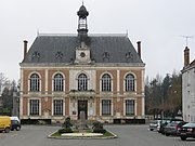
The town hall.
Châtillon-Coligny is a commune in the Loiret department in north-central France.


The Briare Canal in Châtillon-Coligny.
The Loing and the Briare Canal run through the town.
See also[]
Wikimedia Commons has media related to:
- Communes of the Loiret department
- Raynald of Châtillon
| |||||
| This page uses content from the English language Wikipedia. The original content was at Châtillon-Coligny. The list of authors can be seen in the page history. As with this Familypedia wiki, the content of Wikipedia is available under the Creative Commons License. |