| Main | Births etc |
|---|
| Cranfield | |
| Population | 4,909 (2001) |
|---|---|
| OS grid reference | |
| - London | 52 miles (84 km) |
| Parish | Cranfield |
| Unitary authority | Central Bedfordshire |
| Ceremonial county | Bedfordshire |
| Region | East |
| Country | England |
| Sovereign state | United Kingdom |
| Post town | Bedford |
| Postcode district | MK43 |
| Dialling code | 01234 |
| Police | Bedfordshire |
| Fire | Bedfordshire and Luton |
| Ambulance | East of England |
| EU Parliament | East of England |
| UK Parliament | Mid Bedfordshire |
| List of places: UK • England • Bedfordshire | |
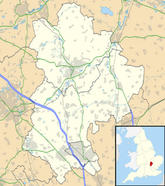
Cranfield is a village and civil parish in north west Bedfordshire, England, between Bedford and Milton Keynes. It has a population of 4,909,[1] and is in Central Bedfordshire District.
The hamlet of Bourne End is located just north of Cranfield, and is part of the civil parish. Wharley End was a separate settlement, but now forms the northern part of Cranfield village, by the university.
Amenities[]
Cranfield has three public houses, a football club, hairdressers, several take-away restaurants, two small supermarkets and three car dealers. There is also a surgery and dentists practice along with a pharmacy. Cranfield has a university, two schools, two parks and a multi-use games area.
The village Post Office is now contained within the Co-op store; previously it was on separate premises near the centre of the village. Cranfield has one of only a small number of Morgan dealerships, in addition to a Ford dealer. There are further facilities at the university campus including a Post Office and bookshop.
Cranfield has a local newspaper called the Cranfield Express.
There is a community web site Cranfieldwebsite.info giving village information, local business, forum etc.
The Church of St Peter and St Paul[2] has records going back at least to 1600, and is notable for its newly restored bells.
From 1992-2005 the village had its own amateur dramatics society, the 'Cranfield Players' with many village members.
Sport & Leisure[]
Cranfield has a Non-League football team Cranfield United F.C. who play at Crawley Road.
Airport[]
Cranfield's airfield was originally an RAF training base, and was used after the war by the College of Aeronautics. Today the main user is the Cabair School of Flying. The future of the airfield is uncertain – one runway was closed to allow the construction of the Nissan building and technology park, and there are controversial plans to build further housing on airfield land. Kennett Aviation, who previously operated a range of vintage aircraft from Cranfield, were forced to move to North Weald due to these plans. However, Cranfield is still home to one of the few remaining serviceable English Electric/BAC Lightning jet fighters.
University[]
Cranfield University is adjacent to the village, on the other side of the airfield.
Technology Park[]
The Cranfield Technology Park is west of the University at the entrance to the campus. It is being developed on a phased basis by Cranfield University and its development partner. The park's objective is to encourage knowledge-based companies to locate their activities on the park and to encourage the growth of such companies. A major extension to the technology park was started in January 2007 using land on Cranfield Airport.
In August 2005 a new business incubation centre was opened. It was designed to encourage and support hi-tech and knowledge based pre-start and early start companies during the formative stages of their development.[3]
References[]
- ^ Office for National Statistics : Census 2001 : Parish Headcounts : Mid Bedfordshire Retrieved 7 March 2010
- ^ http://www.genuki.org.uk/big/eng/BDF/Cranfield/index.html
- ^ "Cranfield University Business Incubation Centre". Cranfield University. http://www.cranfield.ac.uk/business/commercialtenancies/cubic. Retrieved 2008-01-28.
External links[]
- Cranfield Football Club
- Cranfield Colts Football Club
- Cranfield Village Website
- Cranfield Technology Park
- Account of Cranfield during the second world war
| |||||
| This page uses content from the English language Wikipedia. The original content was at Cranfield. The list of authors can be seen in the page history. As with this Familypedia wiki, the content of Wikipedia is available under the Creative Commons License. |

