| ||||||||||||||
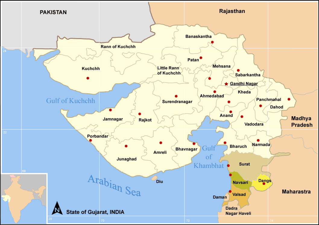
Districts of South Gujarat
Dang (Nepali: दाङ जिल्ला![]() Listen (help·info),(also known as The Dangs) is a district in the state of Gujarat in India. The administrative headquarters of the district are located in Ahwa. The Dangs have an area of 1764 km² and a population of 186,729 (as of 2001). [1]
Listen (help·info),(also known as The Dangs) is a district in the state of Gujarat in India. The administrative headquarters of the district are located in Ahwa. The Dangs have an area of 1764 km² and a population of 186,729 (as of 2001). [1]
As of 2011 it is the least populous district of Gujarat (out of 26).[2]
History[]
Before Independence several wars were fought between the five tribal kings of Dang and the British. According to the history of Dang, the biggest ever war took place at Lashkaria Amba, in which kings of all five erstwhile states got together to protect Dang from British rule. The British were beaten and decided to discontinue war and resorted to compromise.
As per historic compromise treaty was signed in 1842 according to which the Britishers were allowed to use the forests and their natural products against which they had to pay certain amount around 3,000 silver coins to the five kings of the then monarchy. However, currently the kings are offered monthly political pension by the Government of India, which is the main source of their income. This payment is continued even though all privy purses for the Princely states of India was stopped in 1970 since the agreement was between then monarchy of Dangs and the British.
Every year during the financial end the Kings gather in Ahwa for a traditional royal ceremony in their richly decorated buggies, bands with tribal dancers to receive the payment as per the agreement of 1842. In ancient Indian Scriptures Dang is known as Dand Aranyaka, meaning Bamboo Forest.
| State | Population ('000);[3] | Revenue (1881, Rs.) | Ruler's title. Notes |
|---|---|---|---|
| Dang Pimpri | 3,6 | 3106 | 388 km² |
| Dang Wadhwan | 0,253 | 147 | ca. 12 km². Not to be confuesd with the state whose capital Wadhwan was. |
| Dang Ketak Kadupada | 0,218 | 155 | |
| Dang Amala | 5,3 | 2885; 1891: 5300 | Raja. 307 km² |
| Dang Chinchli | 1,67; 1891: ca. 1,4 | 601 | ca. 70 km² |
| Dang Pimpladevi | 0,134 | 120 | ca. 10 km² |
| Dang Palasbishar (= Palasvihir) | 0,223 | 230 | ca. 5 km² |
| Dang Auchar | ca. 500 | 201 | < 21 km² |
| Dang Derbhauti | 4,891; 1891: ca. 5 | 3649 | Raja. 196 km² |
| Dang Gadhavi (= Gadhi) | 6,309 | 5125 | Raja. |
| Dang Shivbara | 0,346 | 422 | ca. 12 km² |
| Dang Kirli (= Kirali) | 0,167 | 512 | 31 km² |
| Dang Wasurna | 6,177 | 2275 | |
| Dang Dhude (= Bilbari) | 1,45; 1891: 1418 | 85 | < 5 km² |
| Dang Surgana | 14 | 11469 | |
| Machhali | 1.1; | 4745 | 35 |
Economy[]
In 2006 the Ministry of Panchayati Raj named Dang one of the country's 250 most backward districts (out of a total of 640).[4] It is one of the six districts in Gujarat currently receiving funds from the Backward Regions Grant Fund Programme (BRGF).[4]
Demographics[]
According to the 2011 census Dang district has a population of 226,769 ,[5] roughly equal to the nation of Vanuatu.[6] This gives it a ranking of 587th in India (out of a total of 640).[5] The district has a population density of 129 inhabitants per square kilometre (330 /sq mi) .[5] Its population growth rate over the decade 2001-2011 was 21.44 %.[5] The Dangs has a sex ratio of 1007 females for every 1000 males,[5] and a literacy rate of 76.8 %.[5]
References[]
- ^ http://www.censusindiamaps.net/page/India_WhizMap/IndiaMap.htm
- ^ "District Census 2011". Census2011.co.in. 2011. http://www.census2011.co.in/district.php. Retrieved 2011-09-30.
- ^ Hunter, W. W.; Imperial Gazetteer of India; London ²1885, Vol. IV, S 115-6
- ^ a b Ministry of Panchayati Raj (September 8, 2009). "A Note on the Backward Regions Grant Fund Programme". National Institute of Rural Development. http://www.nird.org.in/brgf/doc/brgf_BackgroundNote.pdf. Retrieved September 27, 2011.
- ^ a b c d e f "District Census 2011". Census2011.co.in. 2011. http://www.census2011.co.in/district.php. Retrieved 2011-09-30.
- ^ US Directorate of Intelligence. "Country Comparison:Population". https://www.cia.gov/library/publications/the-world-factbook/rankorder/2119rank.html. Retrieved 2011-10-01. "Vanuatu 224,564 July 2011 est."

|
Tapi district | Nandurbar district, Maharashtra |
| |
| Navsari district | Dhule district, Maharashtra | |||
 Dang district | ||||
| Nashik district, Maharashtra |
| ||||||||||||||||||||||||||||||
| This article about a location in Dang District, Gujarat, India is a stub. You can help by expanding it. |
| This page uses content from the English language Wikipedia. The original content was at Dang district. The list of authors can be seen in the page history. As with this Familypedia wiki, the content of Wikipedia is available under the Creative Commons License. |