| ||||||||||||||
| Bijapur district ವಿಜಾಪುರ |
|
|---|---|
| — district — | |
 |
|

Bijapur district |
|
| Coordinates: Coordinates: | |
| Country | |
| State | Karnataka |
| Region | Bayaluseeme |
| Headquarters | Bijapur |
| Talukas | Bijapur, Bagewadi, Sindgi, Indi, Muddebihal, Basavan Bagewadi |
| Area | |
| • Total | 10,541 km2 (4,070 sq mi) |
| Population (2001) | |
| • Total | 1,806,918 |
| • Density | 170/km2 (440/sq mi) |
| Languages | |
| • Official | Kannada |
| Time zone | IST (UTC+5:30) |
| Telephone code | + 91 (0) 8352 |
| Vehicle registration | KA- 28 |
| Website | bijapur.nic.in |
Bijapur is a district in the state of Karnataka in southern India. The city of Bijapur is the headquarters of the district, and is located 530 km northwest of Bangalore. Bijapur is well known for the great monuments of historical importance built during the Adil Shahi dynasty.
History[]


Chand Bibi, the regent of Bijapur (1580-90)
The city established in the 10th–11th centuries by the Chalukyas of Kalyani The city came under the influence of the Khilji Sultanate in Delhi by the late 13th century. In 1347, the area was conquered by the Bahmani Sultanate of Gulbarga. By this time the city was being referred as Vijapur or Bijapur
In 1518, the Bahmani Sultanate split into five splinter states known as the Deccan sultanates, one of which was Bijapur, ruled by the kings of the Adil Shahi dynasty (1490–1686). The city of Bijapur owes much of its greatness to Yusuf Adil Shah, the founder of the independent state of Bijapur. The rule of this dynasty ended in 1686, when Bijapur was conquered by the Mughal emperor Aurangzeb. In 1724 the Nizam of Hyderabad established his independence in the Deccan, and included Bijapur within his dominions. In 1760, the Nizam suffered a defeat by the Marathas, and ceded the region of Bijapur to the Maratha Peshwa. After the 1818 defeat of the Peshwa by the British in the Third Anglo-Maratha War, Bijapur passed into the hands of the British East India Company, and was assigned to the princely state of Satara.
In 1848 the territory of Satara, along with Bijapur, was annexed to Britain's Bombay Presidency when the last ruler died without a male heir. The British carved a new district by the name Kaladagi. The district included present-day Bijapur and Bagalkot districts. Bijapur was made the administrative headquarters of the district in 1885, when the headquarters were moved from Bagalkot. After India's Independence in 1947, the district became part of Bombay state, and was reassigned to Mysore state, later Karnataka, in 1956. The former southern taluks of the district were separated in 1997 to form Bagalkot District.
The citadel, built by Yusuf Adil Shah, a mile (2 km) in circuit, is of great strength, well built of the most massive materials, and encompassed by a ditch 100 yards wide, formerly supplied with water, but now nearly filled up with rubbish, so that its original depth cannot be discovered. Within the citadel are the remains of both Hindu temples and old mosques, which prove that Bijapur was an important town. The fort, which was completed by Au Adil Shah in 1566, is surrounded by a wall 6 m. in circumference. This wall is from 30 to 50 ft (10 to 15 m) high, and is strengthened with 96 massive bastions of various designs. In addition there are ten others at the various gateways. The width is about 25 ft (8 m); from bastion to bastion runs a battlemented curtained wall about 10 ft (3 m) high. The whole is surrounded by a deep moat 30 to 40 ft (10 to 12 m) broad. Inside these walls the Bijapur kings bade defiance to all comers. Outside the walls are the remains of a vast city, now for the most part in ruins, but the innumerable tombs, mosques, caravanserais and other edifices, which have resisted the havoc of time, afford abundant evidence of the ancient splendour of the place.
Badami, Aihole, and Pattadakal, near Bijapur, are noted for their historical temples in the Chalukyan architectural style.
Cities and towns in Bijapur District[]
- Basavana Bagevadi
- Bijapur
- Indi
- Muddebihal
- Sindagi
- Talikota
Attractions[]
Bijapur is rich in historical attractions.
- Gol Gumbaz: This is the most famous monument in Bijapur. It is the tomb of Mohammed Adil Shah (ruled 1627–1657). It is the second largest dome ever built, next in size only to St Peter's Basilica in Rome. A particular attraction in this monument is the central chamber, where every sound is echoed seven times. Another attraction at the Gol Gumbaz is the Whispering Gallery, where even minute sounds can be heard clearly 37 metres away. Gol Gumbaz complex includes a mosque, a Naqqar Khana (a hall for the trumpeters) (now it is used as museum) and the ruins of guest houses.
- Ibrahim Roza: This is the tomb of Ibrahim Adil Shah II (ruled 1580–1627), the fifth king of the dynasty and, like the Mughal emperor Akbar, known for religious tolerance. Built on a single rock bed, it is noted for the symmetry of its features. It is said that the design for the Ibrahim Rauza served as an inspiration for that of the famous Taj Mahal.


The Quran, written in gold at Jumma Masjid
- Jumma Masjid: Built by Ali Adil Shah I (1558–80) is one of largest Mosque in the region. It has a large hall, elegant arches, and an excellent dome with thirty-three smaller domes surrounding it. It has an exquisite copy of the Quran, written in gold. Elaborate entrance gate was built by Emperor Aurangzeb.

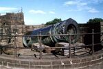
The Gun: Malik-E-Maidan, which means the master of the war front
- Malik-e-Maidan (The Monarch of the Plains) the largest medieval cannon in the world. Being 4 m long, 1,5 m in diameter and weighing 55 tons, this gun was brought back from Ahmadnagar in the 17th century as a trophy of war by 400 oxen, 10 elephants and tens of men. It was placed on the Sherza Burj (Lion Gate) on a platform especially built for it. The cannon's nozzle is fashioned into the shape of a lion's head. It is said that after igniting the cannon, the gunner would remain underwater in a tank of water on the platform to avoid the deafening explosion. The cannon remains cool even in strong sunlight and if tapped, tinkles like a bell. In 1854 the cannon was auctioned for Rs. 150 but the sale was cancelled in the end.
- Uppali Buruj, Built around 1584 by Hyder Khan, is an 80-foot-high (24 m) tower standing to the north of Dakhani Idgah in Bijapur. This is a spherical structure with stone steps winding round the outside. Top of the tower offers a commanding view of the city. This is also known as "Hyder Burj", "Upli Burj". On top of Upli Burj there are two guns of huge size. The parafeet this tower which was used for monitoring purposes has been fenced now. One needs to climb the circular stairs to reach the top. However except for this tower there is very little evidence of the citadel wall in this area due to rampant construction.
- Chand Bawdi, Ali Adil Shah (1558–1580) built this tank near eastern boundary of Bijapur. When there was large influx of people into Bijapur after the fall of the Vijayanagar empire, and new settlements came up within the walled city raising the need for better infrastructure and providing water supply. This has a storage capacity of 20 million litres. Later it became a model for many other tanks constructed in the city. A grandeur complex came up around it, which was mainly used to house the maintenance staff though members of the royal family occasionally used it for recreation. He named this after his wife "Chand Bibi".
- Asar Mahal, The Asar Mahal was built by Mohammed Adil Shah in about 1646, which was used to serve as a Hall of Justice. The building was also used to house the blessed relic - the holy hairs from the Prophet's beard. The rooms on the upper storey are decorated with frescoes and the front is graced with a square tank. Here women are not allowed inside. Every year there is urs (festival) held at this place. In front of the hall, one can see three tanks the bigger tank, which is at the centre is about 15 feet deep however the other two are comparatively smaller in size as well as depth. Behind Asar Mahal one can still see the remain of the citadel. Just a kilometer away behind Asar Mahal, one can still find the old mosque which is on top of the citadel wall. There is a big entrance with arc below this mosque. Many stones have inscriptions. The site is under maintenance of Archeological Survey of India.
- Gagan Mahal, which means Sky Palace, is built with a 21-meter façade and four wooden massive pillars, has a majestic central arch. Sikandar Adil Shah, in silver chains, surrendered to Aurangzeb in 1681 here.
- Barakaman (Ali Roza-II) A mausoleum of Ali Roza built in 1672. It was previously named as Ali Roza, but Shah Nawab Khan changed its name to Bara Kaman as this was the 12th monument during his reign. It has now seven arches and the tomb containing the graves of Ali, his queens and eleven other ladies possibly belonging to the Zenana of the queens.
- Among the other historical attractions at Bijapur, some notable ones are the Anand Mahal, Jod Gumbaz, Sat Manzil, and Jal Manzil.
Geography[]
Geographically, the district lies in the tract of the Deccan Plateaus. The lands of the district can be broadly divided into three zones: the northern belt consisting of the northern parts of Bijapur Taluks of Indi and Sindagi; the central belt consisting of Bijapur city; the southern belt consisting of the rich alluvial plains of the Krishna Rivers parted from the central belt by a stretch of barren Trap. The northern belt is a succession of low rolling uplands without much vegetation, gently rounded and falling into intermediate narrow valleys. The upland soil being shallow, the villagers are generally confined to the banks of the streams and are far away from one another. The Don Volley has plains and consists of rich tracts of deep black soil stretching from west to east. Across the Krishna River is a rich plain crossed from west to east by two lines of sandstone hills. Further south towards Badami and southwest to east by two lines of sandstone hills. Further south towards Badami and southwest of Hunagund, the hills increase the number and the black soil gives way to the red
There are 34 rain gauge stations in Bijapur District. The average annual rainfall for the district is 553 mm with 37.2 rainy days. The monsoon generally breaks in the district during June and lasts till October. The highest mean monthly rainfall is 149 mm in the month of September and lowest is 3 mm in February. The annual rainfall variation in the district is marginal from place to place.
Bijapur District can be categorized as a low to moderately yielding area (1000 to 8000 L/h) 72.2% of district falling in this category. From considerable part of the district (9%) poor yielding (less than 1000 L/h sources) or non–feasible areas have been reported. The talukas having largest poor yielding area, are Muddebihal (19%) followed by Indi (15%), Bijapur and sindagi (13% each), Basavan Bagewadi (4%). Low yielding areas (1000 to 4000 L/h source) in the district constitute about 40% of the district, with the largest being Basavan Bagewadi (54%) and smallest in Indi taluka Moderate yields (4000 to 8000 L/h source) are reported from 36% of the district, highest being in Bijapur with 70% of the area, and lowest being in Sindagi with 19% of the taluka. High yielding areas (more than 8000 L/h sources) over 15% of the district. The smallest area under this category are in Sindagi Taluka (2% each) and largest is in Muddebihal (29% each) where very lengthy contact zones occur between traps and other formations
On the basis of projections from this information, the main parameters affecting water quality in Bijapur can be expected to be Brackishness (Salinity) and Hardness. Salinity affects the district in high to low groundwater problem areas and occurs in areas all along the major and minor river courses and steam courses.
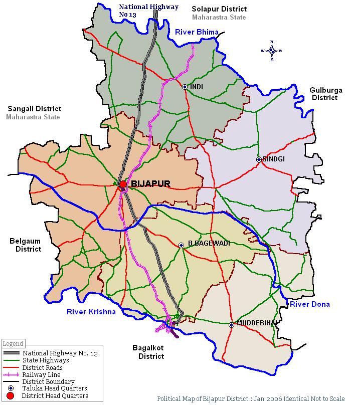

Political map of the Bijapur district
Jnana Yogashram, Asharam Road Bijapur. Founder Shri Mallikarjun Swamiji
Demographics[]
According to the 2011 census Bijapur district, Karnataka has a population of 2,175,102,[1] roughly equal to the nation of Latvia[2] or the US state of New Mexico.[3] This gives it a ranking of 210th in India (out of a total of 640).[1] The district has a population density of 207 inhabitants per square kilometre (540 /sq mi) .[1] Its population growth rate over the decade 2001-2011 was 20.38 %.[1] Bijapur has a sex ratio of 954 females for every 1000 males,[1] and a literacy rate of 67.2 %.[1]
Bijapur District has an area of 10541 square kilometres, and a population of 1,806,918 (2001 census), an increase of 17.63% since the 1991 census. It is bounded on the east by Gulbarga district, on the southeast by Raichur District, on the south and southwest by Bagalkot District, and on the west by Belgaum District, and by the Maharashtra of Sangli on the northwest and Sholapur on the north, Sangli on the north-west (both of Maharastra state),
It consists 5.49% of Karnataka state area. It lies between 15 x 50 and 17 x 28 North Latitude and 74 x 54 and 76 x 28 East Longitude. The administrative headquarters and chief town is Bijapur.

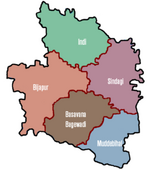
Talukas of Bijapur District
For administrative purposes the district is divided into six taluks.
- Bijapur
- Basavana-Bagewadi
- Indi
- Muddebihal
- Sindgi
- Babaleshwar
The district is 21.92% urban.[4]
Transport[]
Bijapur is connected only by Rail and Road. An Air port has also got sanction. The helipad at the Sainik School is used only when government guests or public office bearers visit the district and is not open for general public. The state owned[5] run buses to all parts of the district. Private tour operators also run luxury bus services to Bangalore, Hubli, Dharwad and Belgaum. Travelers can book tickets online through.[6]
Bijapur is a Broad gauge station of South Western Railways,[7] with direct train connections to Bangalore, Mumbai, Hyderabad, Hubli, Sholapur and Shirdi.
The public transport of the district is managed by the State Road Transport Corporation which runs local buses within city limits as well as villages within the 15 km radius. The frequency of these buses are higher in comparison to the buses which ply on longer routes. Tata Sumo, Tata Indica and[8] are used as taxis by local operators. Autos and Tongas are still popular mode of local transport in the city. Cycle Rickshaws are used only to transport materials and people hardly travel by them.
Tourism[]
Best Time to Visit : October to March (During Winters)
Air – The nearest airport is at Belgaum (205 km). Indian and Jet airways flight operators connect Bijapur to the rest of India.
Rail – Bijapur is well connected by rail with Bangalore and other major cities of India (Bombay, Bengaluru, Hyderabad, Pune, Hubli and Solapur). It has its own railhead that is located just 2 km from the main town.
Road – The main stand in Bijapur is near the southwestern side of the citadel, near the city center. Bus services to Badami (2 hours), Belgaum (5 hours), Gulbarga (4 hours), Bidar (7 hours), Hubli (4½ hours), and Sholapur (2 hours) are frequent.
Excursions: The famous and historical temple Golageri Sri Gollaleswar temple-78 km, Alihole – 110 km, Saint Basaveshwara Pilgrim – 67 km, Basavana Bagevadi – 43 km, Alamatti – 56 km, Badami – 60 km, Gulbarga – 145 km, Bidar – 256 km, Bangalore – 530 km, Mysore – 650 km.
People and culture[]

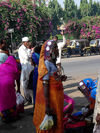
Lambani women
People from the central Asian regions settled in this part, when they landed as part of the caravan with the muslium rulers. The local population is mainly a mix of Dravidian and Aryan descendants. Majority of people are Muslims. As per the 2001 census 3,34,254 people belong to the Scheduled Castes and 30,051 to the Scheduled Tribes. People belonging to the Lambani tribe have settled in the districts since long. The villages in which these groups live are referred as "Tandas"
Sports[]
Off late Bijapur district has produced some of the best known Road Cyclists in the national circuit. Premalata Sureban was part of the Indian contingent at the Perlis Open '99 in Malaysia.[9]
Dr. B.R.Ambedkar Sports complex serves as the main centre for all activities related to sports. Facilities are available in the single sports complex for track and field events, volleyball, basket ball, cricket and a velodrome for cycling. Apart from the government-managed infrastructure the private trust run BLDEA's Medical and Engineering college campus has also access to the state-of-the art facilities for fitness and sports. It can be noted that the popular games in the rural areas are Kabaddi and Kho Kho apart from Cricket. Cricket is still popular among local youth however having a winning team of Volley ball and football is a matter of prestige for all the schools and colleges.
Every year the district administration organizes the Dasara Sports Meet during the Dasara festival to identify and nurture the talent of the future.
Art and culture[]
Navaraspur was the auditorium of the Adil Shahs, it is about 10 km outside the city limits. The ruins of the site are still visible. Every year the local administration organizes the Navaraspur Festival to attract tourists. Great personalities like Bhimsen Joshi, Ustad Alla Rakha, Zakir Hussain, Mallikarjun Mansur, Gangubai Hangal and many more have performed in this festival.
- Shiddeshwar Temple situated at the heart of the city is a holy place for Hindus which is also a very beautiful tourist place to visit. During Makar Sankranti an annual fare is organized by Siddheshwar Temple. This fair is well known for the cattle market which is organized outside the city limits. Farmers from neighboring villages and even some parts of Maharastra come to trade in cattle. During this period fireworks display will be held.
- The Kittur Rani Chenamma Theatre still stages dramas by professionals. However due to the decrease in the patronization the drama companies are closing down. Ninasam, (Shri Nilakanteshwara Nataka Sangha), an experimental theatre troupe started by [10] visit Bijapur and show case their art during the Ninasam "Tirugata" (meaning: Wandering in Kannada) Kandgal Hanumantharayara Ranga Mandira on the station road, serves as the centre of art of culture. During summer many workshops on theatre are held at this auditorium under the sponsorship of the local administration.
Sufism In Bijapur[]
Bijapur has been well known as the Madinatul Auliya (Sufis) or the City of Sufi Saints. Various Auliya (Sufi Saints) have visited Bijapur and most of them made this city their resting place too. Auliya of almost all spiritual linage like Qadriya, Sakafya, Ashraifya, Shuttariya, Nasqbhandiya, Chisitya are to be found in this city. The Following is a brief list of Great Sufis.
- Hazrath Sayed Jaffer Sakaf Quadri Sadat (RH)
- Hazarth Sayed Abdul Razak Qadri (RH)
- Hazrath Khwaja Ameenuddin Chisty (RH)
- Hazrath Sayed Murtuza Shah Qadri (RH)
Economy[]
Farming and agriculture related business is the main occupation for many people in the district. Of the total geographical area of 10,530 square kilometres, 7,760 square kilometres is available for cultivation which is 74% of the total area, while areas under forest account for only 0.19% of the total area. Only 17.3% of the net cultivable area is irrigated and the balance 82.7% of the area has to depend on the monsoon.
The cropping pattern in the district reveals that food crops like jowar, maize, bajra and wheat among cereals, red gram, Bengal gram and green gram among pulses are major crops cultivated in the district. The major oilseed crops are sunflower, groundnut and safflower. Horticulture crops like grapes, pomegranate, ber, guave sapota, lime are also grown. A recent trend shows that there is a low shift towards fruit crops like Pomegranate and grapes of the total area of 8,610 square kilometres. Covered during 2002-03 cereals occupy about 55.2% by oilseeds 24.5% pulse 15.6% and other commercial crops like cotton and sugarcane about 4.8%. There is a slight shift towards commercial crops like cotton and sugarcane over last 2 years. The land holding pattern in the district indicates that small and marginal farmers account for 4% of total land holdings and 0.6% of the total land, semi-medium for 27.5% with 10.1% of total land while 68% of the holdings are above 20,000 m², accounting for 89.3% of land. Many small scale industries are working in the district however no large scale industry can be found in the district.
| Classification of Labor Force | No. of Workers |
| Cultivators or Farmers | 2,21,060 |
| Agricultural Laborers (Non-Land Owners) | 2,87,778 |
| Artisans | 17,776 |
| Home based / Cottage Industries | 18,232 |
| Services and Other sector | 1,95,573 |
Education[]
Of late Bijapur is emerging as a hub for professional education. Previously (i.e. before 1980s) there were very few professional educational institutions. Along with the professional colleges there are many colleges which provide under-graduate and post-graduate degrees in the faculty of arts, science and social-sciencesMany of these colleges except professional are affiliated to Karnatak University Dharwad. Karnatak University has a Post-Graduation Centre at Bijapur also. Engineering colleges are affiliated to Visvesvaraya Technological University and Medical colleges are affiliated to Rajiv Gandhi University of Health Sciences.[11] Various post graduate course are conducted here. At present there are 47 affiliated colleges under jurisdiction of 12 districts namely Bagalkot, Belguam, Bellary, Bidar, Bijapur, Dharwad, Gadag, Gulbarga, Haveri, Koppal, Raichur, Uttar Kannada Additionally Bijapur boasts of the only Sainik school in the whole state. This is a residential school preparing cadets for the Defence forces.
The Bijapur district is known for its temples, structural monuments, art and architectural heritages, archaeological sites and cave temples. With the objective to spread education in this area, Karnatak University opened its Post-Graduate Centre in 1993.
IGNOU Bijapur Reginol Center[]
Bijapur has IGNOU regional center. There are 7 districts under its jurisdiction(Districts Bagalkote, Bijapur, Bidar, Gulbarga, Koppal Raichur and Yadgir).The newly created Bijapur Regional Centre would cater to seven northern districts.
Political scenario[]
The Bijapur district is represented by seven members in the Karnataka Legislative Assembly (Lower House) and in the (Upper House) Karntaka Legislative Council five members. A single member represents the whole district in the lower house of Parliament Lok Sabha.
The assembly constituencies under the Bijapur district are
- Muddebihal
- Devara Hipparagi
- Bijapur (Bijapur Urban)
- Basavana Bagewadi
- Babaleshwar
- Indi
- Naghathana
- Sindagi
Notable people[]
- Bhāskara II
- Basava - philosopher and a social reformer (Born in Ingaleshwar)
- Ranna - ರನ್ನ - one of the earliest poets of Kannada language
- B. D. Jatti
- Channabasappa Ambali - Freedom fighter,social reforme and first MLA of Tikota
- S. R. Kanthi
- Venkanna H. Naik
- Amirbai Karnataki
- Aluru Venkata Rao
- M. M. Kalburgi
- Sunil Kumar Desai – One of the finest filmmaker of Kannada film industry
- Basant Kumar Patil – KFCC president and well known film producer.
- DR Saraswati chimmalgi – AIPC president(new delhi) and famous poet in north karnataka.
- Neelamma Malligwad – International cyclist,many awards winner
- Sirajuddin.M.Horaginamani – M.Sc Env.Sci (Gold Medalist),Environmentalist
- Premalata Sureban – International cyclist (Participated in perlis open 99 in Malaysia)
- M.B.Patil (M.L.A)
- Sri Siddeswar Swamiji- Popularly known as living god
- Shivanand Hiremath - founder of Swarnanjali, a cultural organization located in Central Ohio(USA)
Oldest trees in the state[]
- Adansonia digitata-Malvaceae in Bijapur taluk, which is 600 years old;
- Adansonia digitata-Malvaceae in Bijapur taluk, 359 years old;
- Tamarindus indica (tamarind) in Devarahipparagi village of Bijapur – 883 years old;
- Azadirachta indica (Bevu) – at T Venkatapura in Chikkaballapur district 200 years old;
- Ficus benghalensis (Alada mara) in Chickkahalli in Mysore taluk – 260 years old;
- Ficus religiosa (peepal) in Manasagangothri of Mysore – 160 years old;
- 'Kempu boorga mara' in Palace Gate of Mysore – 130 years old;
- Ficus benghalensis (Doddalada mara) – Kethohalli in Bangalore, 400 years old;
- Araucaria cookie – Lalbagh, 140 years old;
- 'Pilali' (Ficus Micro Corpus) – in Banavasi of Shimoga district – 400 years old.
- How the Adansonia digitata tree came to Bijapur
Two of these trees, commonly known as the baobab trees, have been listed and identified in Bijapur. One is near the Ibrahim Roza monument in Bijapur with a girth of 10.84 m and height of 5 m and another at Yogapur Dargah, near Bijapur, which is believed to be at least 359 years old with 9.2 m girth and seven m height. Both these trees were planted during the reign of Adil Shahis. Experts say that the kings of Adil Shahi dynasty were all fascinated by nature, and these particular saplings of the adansonia digitata had been imported from Turkey to be planted in Bijapur. The kings were very particular about the nurturing of these plants and took care of their needs like their own children.
See also[]
- Bijapur Fort
References[]
- This article incorporates text from the Encyclopædia Britannica Eleventh Edition, a publication now in the public domain.
- "Samanya Mahiti"a periodical released by the Bijapur Zilla Parishad.
- ^ a b c d e f "District Census 2011". Census2011.co.in. 2011. http://www.census2011.co.in/district.php. Retrieved 2011-09-30.
- ^ US Directorate of Intelligence. "Country Comparison:Population". https://www.cia.gov/library/publications/the-world-factbook/rankorder/2119rank.html. Retrieved 2011-10-01. "Latvia 2,204,708 July 2011 est."
- ^ "2010 Resident Population Data". U. S. Census Bureau. http://2010.census.gov/2010census/data/apportionment-pop-text.php. Retrieved 2011-09-30. "New Mexico - 2,059,179"
- ^ Census GIS India Archived [[{{{dateformat}}} 2007-07-27|{{{dateformat}}} 2007-07-27]], [[{{{3}}}|{{{3}}}]] at WebCite
- ^ North West Karnataka State Road Transport Corporation Archived [[{{{dateformat}}} 2011-01-31|{{{dateformat}}} 2011-01-31]], [[{{{3}}}|{{{3}}}]] at WebCite
- ^ [www.ksrtc.in]
- ^ Complete Info SWR Archived [[{{{dateformat}}} 2011-01-31|{{{dateformat}}} 2011-01-31]], [[{{{3}}}|{{{3}}}]] at WebCite
- ^ Tempo Trax
- ^ [1]
- ^ K.V.Subanna Archived [[{{{dateformat}}} 2011-01-31|{{{dateformat}}} 2011-01-31]], [[{{{3}}}|{{{3}}}]] at WebCite
- ^ RGUHS-homepage Archived [[{{{dateformat}}} 2011-01-31|{{{dateformat}}} 2011-01-31]], [[{{{3}}}|{{{3}}}]] at WebCite
https://www.facebook.com/pages/Bijapur-Beauty/286380871418949
External links[]
- Tourist information of Bijapur and places nearby
- A Complete Information Portal of Bijapur
- Profiles of all the Districts in Karnataka
- Bijapur District
- Bijapur Jawari Food
- Bijapur Heritage
- Profile of Adil Shah II.
- Bijapur at the Islamic Monuments of India Photographic Database
- SUFIS OF BIJAPUR
- IGNOU in the hindu newspaper

|
Sangli district, Maharashtra | Solapur district, Maharashtra |
| |
| Belgaum district | Gulbarga district Yadgir district | |||
 Bijapur district | ||||
| Bagalkot district | Raichur district |
| |||||||||||||||||||||||||||||
| ||||||||||||||
| This page uses content from the English language Wikipedia. The original content was at Bijapur district, Karnataka. The list of authors can be seen in the page history. As with this Familypedia wiki, the content of Wikipedia is available under the Creative Commons License. |