| Main | Births etc |
|---|
| East Grinstead | |
 High Street |
|

East Grinstead | |
| Area | [1] |
|---|---|
| Population | 23,942 [1] 2001 Census |
| - Density | |
| OS grid reference | |
| - London | 26 miles (42 km) N |
| Parish | East Grinstead |
| District | Mid Sussex |
| Shire county | West Sussex |
| Region | South East |
| Country | England |
| Sovereign state | United Kingdom |
| Post town | EAST GRINSTEAD |
| Postcode district | RH19 |
| Dialling code | 01342 |
| Police | Sussex |
| Fire | West Sussex |
| Ambulance | South East Coast |
| EU Parliament | South East England |
| UK Parliament | Mid Sussex |
| Website | East Grinstead Town Council |
| List of places: UK • England • West Sussex | |
East Grinstead is a town and civil parish in the northeastern corner of Mid Sussex, West Sussex in England near the East Sussex, Surrey, and Kent borders. It lies 27 miles (43 km) south of London, 21 miles (34 km) north northeast of Brighton, and 38 miles (61 km) east northeast of the county town of Chichester. The civil parish covers an area of 2443.45 hectares (6,035 acres) and had a population of 23,942 persons in the 2001 census. Nearby towns include Crawley to the west, Tunbridge Wells to the east and Redhill and Reigate to the northwest. The town is continuous with the village of Felbridge to the northwest. Until 1974 East Grinstead was the centre for local government - East Grinstead Urban District Council - and was located in the county of East Sussex. East Grinstead, along with Haywards Heath and Burgess Hill, as part of the former Cuckfield Rural District Council, came together as Mid-Sussex; moving to the jurisdiction of West Sussex County Council. The town has many historic buildings and is located on the Greenwich Meridian. It is located in the Weald and Ashdown Forest lies to the south of the town.
Places of interest[]
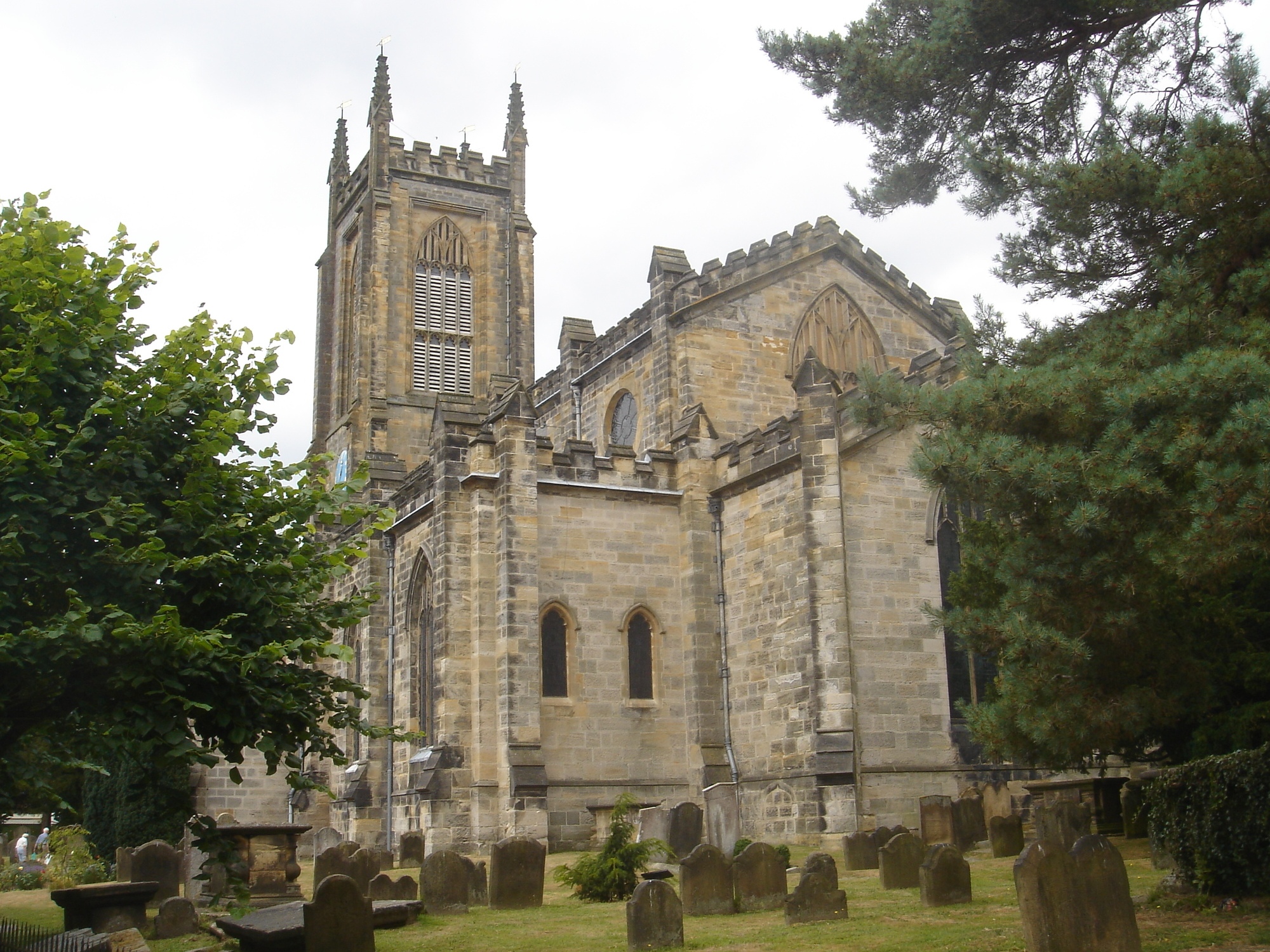
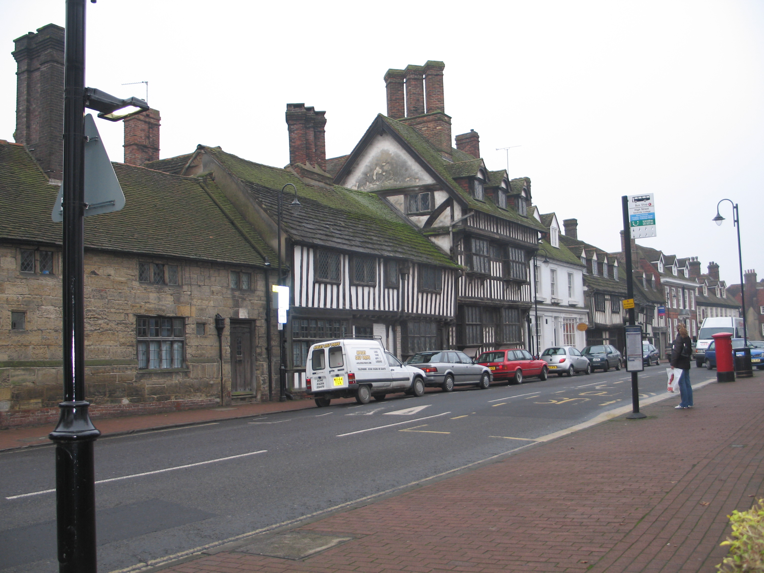
The High Street contains the longest continuous run of 14th-century timber-framed buildings in England. Other notable buildings in the town include Sackville College, the sandstone almshouse built in 1609 where the Christmas carol "Good King Wenceslas" was written by John Mason Neale. The college has sweeping views towards Ashdown Forest. The adjacent St Swithun's Church, stands on the highest ground in the town and was rebuilt in the eighteenth century (the tower dating from 1789) to a perpendicular design by James Wyatt; its imposing building dominates the surrounding countryside for many miles around. In the churchyard are commemorated the East Grinstead Martyrs; and in the south-east corner is the grave of John Mason Neale. The Greenwich Meridian runs through the grounds of the historic 1769 East Court mansion, home of the Town Council,[2] giving the visitor an opportunity to stand with a foot in both the east and west. The mansion stands in a parkland setting. In 1968 the East Grinstead Society[3] was founded as an independent body both to protect the historically important buildings of East Grinstead (and its environs) and to improve the amenities for future generations.
On the outskirts of the town is Standen, a country house belonging to the National Trust, containing one of the best collections of arts and crafts movement furnishings and fabrics. On the A264 to Tunbridge Wells, there is a historic house called Hammerwood Park which is on occasions open to the public. East Grinstead House is the headquarters of the (UK and Ireland) Caravan Club.
Local attractions include Ashdown Forest (where the Winnie-the-Pooh stories are set) and the Bluebell Railway, a preserved heritage line with steam locomotives. The town is also the site of Queen Victoria Hospital, where famed plastic surgeon Archibald McIndoe treated burns victims of World War II and formed the Guinea Pig Club. The town is well located to visit Chartwell the country home of Sir Winston Churchill, Hever Castle home of Henry VIII's second wife Anne Boleyn, and Penshurst Place home of the Sidney family. Kidbrooke Park (today Michael Hall School), a home of the Hambro family, was restored by the noted Sussex architect and antiquarian, Walter Godfrey, as was Plawhatch Hall.
During the Second World War, the town was a secondary target for German bombers who failed to make their primary target in London. During the evening of 9 July 1943, a Luftwaffe bomber became separated from his squadron, and made an attack on the town. One of his bombs fell on the Whitehall Cinema in the High Street. 108 people were killed, including many children who were watching the matinee. This was the largest loss of life of any single air raid in Sussex.
In 2006, the East Grinstead Town Museum [4] was moved to new custom built premises located in the historic centre of the town, and successfully re-opened to the public. The Chequer Mead Community Arts Centre[5] includes a modern 349-seat purpose-built theatre, which stages professional and amateur plays and music (local rock groups to chamber music orchestras), opera, ballet, folk music, tribute bands, and talks. The centre has a large art gallery for temporary exhibitions.
In addition to the nearby Ashdown Forest, East Grinstead is served by the Forest Way and Worth Way linear Country Parks which follow the disused railway line from Three Bridges all the way through to Groombridge and which are part of the Sustrans national cycle network. To the south of the town lies the Weir Wood Reservoir which offers sailing[6] and a nature reserve which attracts an interesting assortment of birdlife. It is designated a Site of Special Scientific Interest.
Religious organisations[]

St Swithun's Church


London England Temple
East Grinstead has an unusually diverse range of religious and spiritual organisations for a town of its size.[7][8][9] A broad range of mainstream Christian denominations have places of worship in the town, and several others used to be represented; Protestant Nonconformism has featured especially prominently for the last two centuries, in common with other parts of northern Sussex.[10] Several other religious groups have connections with the town, from merely owning property to having national headquarters there.[9]
The Church of England has four places of worship in the town. St Swithun's Church was founded in the 11th century. Architect James Wyatt rebuilt it in local stone in 1789 after it became derelict and collapsed.[11][12] Near the entrance to the church, three stones mark the supposed ashes of Anne Tree, Thomas Dunngate and John Forman who were burned as martyrs on 18 July 1556 because they would not renounce the Protestant faith. John Foxe wrote about them in his 1,800-page Foxe's Book of Martyrs.[13] Two other churches are in St Swithun's parish.[14] St Luke's Church in Holtye Avenue on the Stone Quarry estate was built in 1954 to serve the northeast of the town.[15] St Barnabas' Church in Dunnings Road serves the south of the town; the present wooden structure of 1975 replaced an older church built in 1912.[16] The fourth church, in the northwest of the town, is dedicated to St Mary the Virgin. Built by W.T. Lowdell over a 21-year period beginning in 1891, the Decorated Gothic church was consecrated in 1905. It was established by adherents of the Oxford Movement, and services still follow a more Anglo-Catholic style than East Grinstead's other Anglican churches.[11][17][18]
Roman Catholics worship at the Church of Our Lady and St Peter, founded in 1898 by Edward Blount of the Blount baronetcy, a resident of nearby Worth.[19] East Grinstead's first Nonconformist church was the Zion Chapel, built in 1810 for the Countess of Huntingdon's Connexion. The small evangelical Calvinistic group owned the church until 1980; it is now used by Baptists and is called West Street Baptist Church.[18][20] Trinity Methodist Church is the much-expanded successor to older places of Methodist worship in the town; the community dates back to 1868.[11][18][21] The United Reformed Church community meets in the Moat Church, a former Congregational chapel built in the Early English style in 1870.[11][18] Jehovah's Witnesses worship at a modern kingdom hall; the community, established in 1967, previously used a former Salvation Army building.[21] The Mormon church on Ship Street was built in 1985.[22] A 2007 book also noted the New Life Church—a New Frontiers evangelical charismatic church—the Kingdom Faith Church, another independent charismatic congregation, and the Full Gospel Church.[9]
The Opus Dei sect have premises in the town, and Rosicrucians also have a presence. The United Kingdom headquarters of the Mormons, the London England Temple, is just over the Surrey border at Newchapel;[23] and the United Kingdom (and former world) headquarters of the Church of Scientology is at Saint Hill Manor on the southwestern edge of East Grinstead. Scientology's founder L. Ron Hubbard bought the Georgian mansion and its 24 hectares (59 acres) of grounds from the Maharaja of Jaipur in 1959, and lived in the town until 1967.[9]
In 1994, a documentary entitled Why East Grinstead? was produced for Channel 4's Witness strand of documentaries. It sought to examine and explain the convergence of such a wide variety of religious organisations in the East Grinstead area. The documentary, produced by Zed Productions and directed by Ian Sellar, reached no definite conclusion: explanations ranged from the local presence of ley lines to the more prosaic idea that religious leaders had settled there because they liked the views.[9][24]
Redevelopment[]

A long row of 14th century timber framed buildings in England located on East Grinstead High Street.
The East Grinstead Town Centre Master Plan was adopted on 10 July 2006 as a Supplementary Planning Document (SPD). The scheme arranges regeneration of the town centre in association with Thornfield Properties PLC. As of September 2007 Thornfield Properties has submitted plans to the council for the start of an ambitious development of the Queens Walk and West Street area. It is expected that other redevelopment companies will fulfil targets outlined in the SPD over the next 20 years. Landowners and developers are being encouraged to put forward plans achieve the vision set out in the SDP. The Master Plan is part of a larger scheme which will also see the redevelopment of the Haywards Heath and Burgess Hill town centres.[25]
A legacy of 1970s buildings followed by decades of low investment and short term planning have left the town with outdated retail spaces. The plan envisions a complete reconstruction of large parts of the town centre with a new town square as its focal point, a mix of commercial retail space, increased active shop frontage, and over 600 residential properties. The clear priority as stated by Mid Sussex District Council is the regeneration of the town centre, Queensway car park, Queens Walk and West Street.
The problems the town faces have directly affected the volume of trade and the town's economic well-being. Residents do most of their non food shopping out of town, which has resulted in retailers in the town centre closing down and commercial premises being left vacant as they cannot compete with the more attractive shopping centre in Crawley with its better transport infrastructure and larger shop areas.[26] No public money is being spent, with the SPD being a guide for private developers and landowners to pursue the ideas. The SPD helps this in that it in essence shows locations in town that have been given an arbitrary planning permission for projects as long as they fulfil the guidelines set out in the SPD.
A new bypass is planned to ease congestion. A projected increase in population from new housing developments and an increase in tourism from the proposed linking of the town with the heritage Bluebell Railway will service the plans to regenerate the town centre. These plans have been welcomed by many although various public consultations made it clear that any development must retain the town's character. The railway station will also be redeveloped as its simple concrete construction is seen as unattractive and a bad gateway into the town, along with the dilapidated state of the Railway Approach road that leads into town. The current station was built to replace a grand wooden Victorian-era railway station that was sold and moved to the USA. Public transport has also come under criticism for being badly linked and of poor quality, resulting in many residents using private cars to move around, further increasing congestion, with limited public car parking space in town. Other parts of the plan require new car parks, alterations to the external appearance of retail areas, among other improvements to the town.[26]
However, with the collapse of Thornfield Properties, the principle developer, the future of the entire redevelopment scheme has been placed in doubt, additionally submitted plans by Network Rail for a new train station have been condemned by the town council as being insufficient in scope and quality while Marks and Spencers have confirmed after a protracted period that they will not be developing a key site in town for a store.
Geography[]

|
Redhill, Reigate | Lingfield | Edenbridge |
|
| Crawley Down, Crawley | Royal Tunbridge Wells | |||
 East Grinstead | ||||
| Haywards Heath | Weir Wood Reservoir | Forest Row, Crowborough |
Crime[]
Crime rates in East Grinstead are lower than the national average.[27]
| Offence | Locally | Nationally |
|---|---|---|
| Robbery | 0.32 | 1.85 |
| Theft of a motor vehicle | 1.79 | 4.04 |
| Theft from a motor vehicle | 5.34 | 9.59 |
| Sexual offences | 0.62 | 1.17 |
| Violence against a person | 11.28 | 19.97 |
| Burglary | 2.58 | 5.67 |
Transport[]

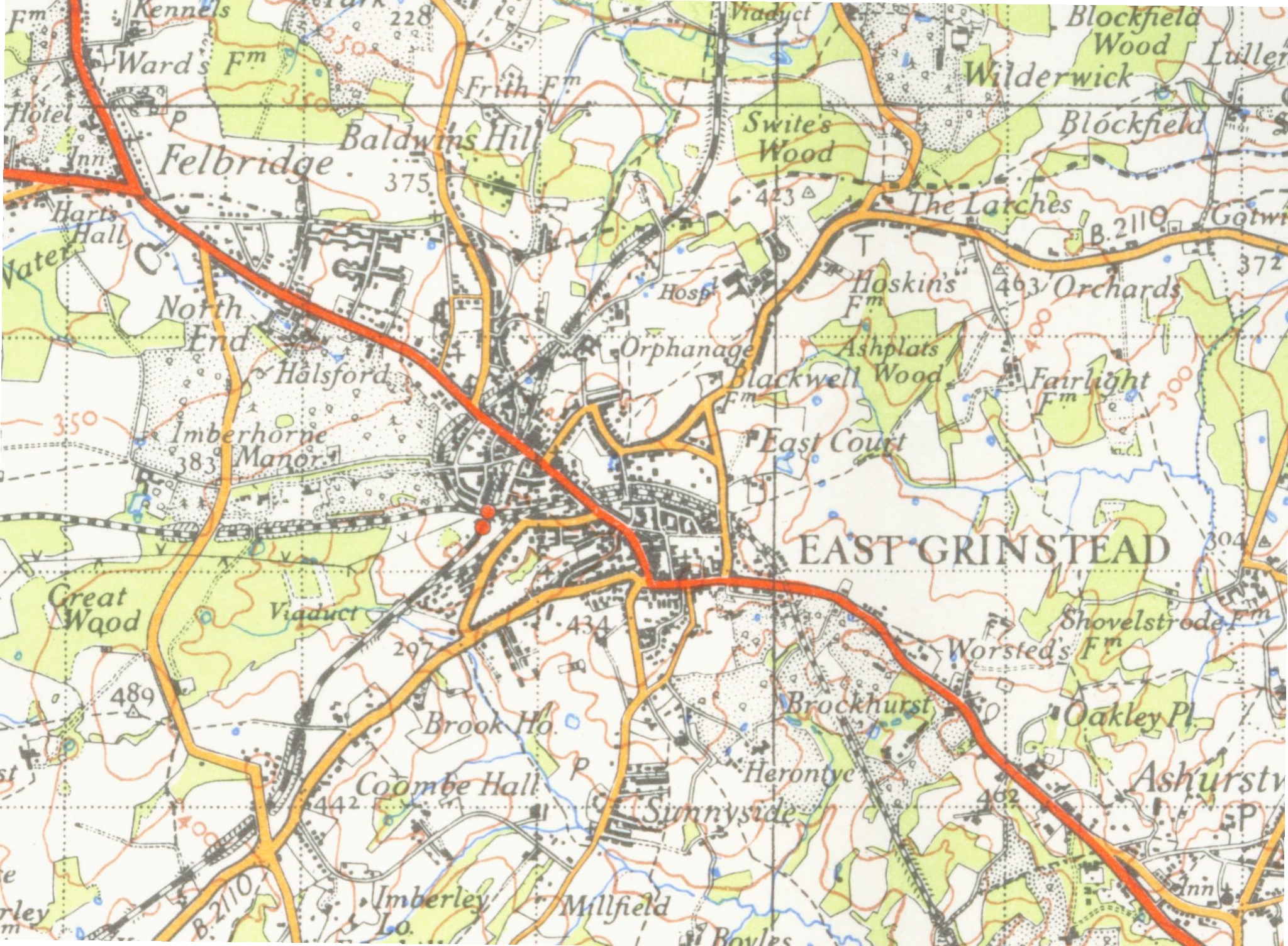
A map of East Grinstead from 1946
Rail[]
East Grinstead has been a railway terminus since 1967, after the line from Three Bridges, to Royal Tunbridge Wells was closed under the Beeching Axe, a rationalisation of British Railways' branch lines based on a report by Dr Richard Beeching, a resident of the town at that time. (see also East Grinstead railway station for history of rail lines). The closure of the line to Lewes part of the Bluebell Railway, occurred in 1958.
In the late 1970s the town's inner relief road was built along a section of one of the closed railway lines and is named "Beeching Way". It is rumoured that this road, which runs through a cutting, was intended to be called "Beeching Cut", but that the name was altered at the last minute in the interests of formality. Much of rest of the trackbed of the disused Three Bridges to Groombridge line now forms the route of the Worth Way and Forest Way, highly prized linear Country Parks allowing easy access to the beautiful Wealden countryside.
Bluebell Railway connection[]
A part of the Lewes line is being re-constructed by the Bluebell Railway,[28] a nearby preserved standard gauge railway. Work has now actively started on the final push to the north towards East Grinstead where the line will once again join onto the national railway network. A new railway station is to be built just south of the main-line station.
Road[]
The town lies on the junction of the A22 and A264 roads. For just over a mile, from just to the north of the Town Centre to Felbridge village in Surrey, the two routes use the same stretch of single carriageway road. This is one of the principal causes of traffic congestion in the town.
The town is within commuting distance of London (about 30 miles) and Crawley/Gatwick (about 10 miles) by road. According to the 2001 Census, one in eight residents commuted to Crawley for work with over 98% travelling by car.
Education[]
Education in the town is provided through both state and independent schools. West Sussex County Council provides seven primary schools along with two secondary schools. All these schools are co-educational and comprehensive. Private secondary education is provided by several day and boarding schools in the surrounding areas straddling Kent and Sussex.
- State primary schools
- Baldwins Hill Primary School - a 100-pupil primary school in buildings opened in 1898. It is federated with Halsford Park Primary
- Blackwell Primary School - a 200-pupil primary school opened in 1955, moving into new buildings in 2006.
- Estcots Primary School - a 400-pupil primary school built in the 1970s
- Halsford Park Primary School - a 400-pupil primary school, opened in 1958 and now federated with Baldwins Hill Primary
- Meads Primary School - a 250-pupil primary school
- St Mary's CE Primary School - a 200-pupil Church of England primary school, originally opened in 1885 moving to current buildings in 1955
- St Peter's RC Primary School - a 200-pupil Roman Catholic primary school, originally opened in 1885
- State secondary schools
- Imberhorne School
- Sackville School
- Private prep schools
- Brambletye, Lewes Road, East Grinstead - Full Boarding, Day, BOYS: Nursery, Pre Prep, Prep , GIRLS: Nursery, Pre Prep, Prep
- Fonthill Lodge School, Coombe Hill Road, East Grinstead - Day, BOYS: Nursery, Pre Prep, Prep , GIRLS: Nursery, Pre Prep, Prep
Families seeking education in faith schools are required to travel to schools in Crawley.
Twin towns[]
The town is twinned with the towns of:
 Bourg-de-Péage, France
- Sant Feliu de Guíxols, Spain
- Mindelheim, Germany
- Schwaz, Austria
- Verbania, Italy
Landmarks[]
There are some Sites of Special Scientific Interest within the parish. Stone Hill Rocks are 8 metres (26 ft) tall sandstone crags in the south of the Parish. They are of interest as they reveal a three dimension picture of the sedimentary make up of the surrounding geology.[29]
Famous residents[]

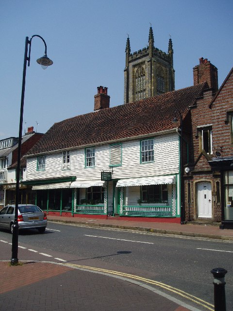
Houses and shops in East Grinstead
- Dr. Richard Beeching
- W. H. Davies with wife Helen (first home at Tor Leven, Cantelupe Road, after marrying at the Register Office).
- Neil Gaiman
- Ted Hutt
- Jane Leeves
- Rev. Dr. John Mason Neale
- Sir Archibald McIndoe
- Sir Patrick Moore (lived at Glencathara, Worsted Lane, 1929–1965)
- Louise Redknapp
- Andrew Sullivan
- Johnny Waldron
- George Godley
- Right Said Fred
- Peter Andre
East Grinstead in literature[]
- East Grinstead is the destination of the adulterous lovers Norman and Annie in Alan Ayckbourn's trilogy of plays entitled The Norman Conquests. It was chosen because Norman, after some effort, couldn't get in at Hastings. In the 1978 BBC T.V. version of the trilogy, Norman and Annie were portrayed by Tom Conti and Penelope Wilton.
- East Grinstead also features in Christopher Fowler's novel, Psychoville (1996), in which the town features as harbouring the fictional Invicta Cross, as well as the eventual New Invicta. The town of New Invicta was later used by Jo Amey in Heist as a safehouse
- East Grinstead is mentioned in the lyrics to British musician Robyn Hitchcock's song, Listening To The Higsons. ("The Higsons come from Norwich, but I prefer East Grinstead.")
- East Grinstead is the home of Harry Witherspoon, one of the lead characters in a musical comedy by Flaherty and Ahrens called "Lucky Stiff".
- East Grinstead is mentioned a couple of times in Monty Pythons Flying Circus. It was mentioned that several letters come from the "East Grinstead Friday."
- East Grinstead is the hometown of Katie Castle in the chick lit novel The Favours and Fortunes of Katie Castle (US title: Slave to Fashion) by Rebecca Campbell.
Sports and social clubs[]
East Grinstead is well served by local sports and social clubs. Municipal facilities include the King George's Field, named as a memorial to King George V. The King's Centre leisure centre, currently owned and operated by Mid Sussex District Council is located on this land, which was left to the town by a local benfactor. The centre includes an indoor swimming pool and other facilities such as a gym and sports hall.[30] The Council is currently reviewing the provisions of this facility and as part of this is looking at contracting out the management. There are floodlit tennis courts and bowling green at Mount Noddy and also tennis courts and a variety of pitches at East Court.
Media[]
The local weekly newspaper is the East Grinstead Courier & Observer, published each Thursday.
The local community radio station is 107 Meridian FM, found on 107 FM and also online.
References[]
Notes[]
- ^ a b 2001 Census: West Sussex – Population by Parish, West Sussex County Council, http://www.westsussex.gov.uk/communityandliving/census2001/pop_parish_summary.pdf, retrieved 7 April 2009
- ^ East Grinstead Town Council , Centre website
- ^ East Grinstead Society Link, Society's website
- ^ East Grinstead Town Museum Link, Museum website
- ^ Chequer Mead Community Arts Centre , Centre website
- ^ Weir Wood Sailing Club , Sailing Centre website
- ^ "Context: East Grinstead Town Centre" (PDF), East Grinstead Town Centre Master Plan (Supplementary Planning Document) (Mid Sussex District Council): p. 12, August 2006, http://www.midsussex.gov.uk/Nimoi/sites/msdcpublic/resources/EGmasteraug06_03context02a.pdf, retrieved 2 March 2010
- ^ "East Grinstead Snapshot" (PDF), East Grinstead Action Plan (Supplementary Report) (East Grinstead Town Council): p. 7, 2 February 2003, http://www.eastgrinstead.gov.uk/actionplan/supplementaryreport2.pdf, retrieved 2 March 2010
- ^ a b c d e Bridgewater 2007, pp. 48–49.
- ^ Harris 2005, pp. 16–17, 19.
- ^ a b c d Elleray 2004, p. 23.
- ^ Harris 2005, pp. 13, 17.
- ^ Collins 2007, p. 39.
- ^ "St Swithun, East Grinstead", A Church Near You website (Archbishops' Council), 2009, http://www.achurchnearyou.com/east-grinstead-st-swithun/, retrieved 5 March 2010
- ^ Leppard 2001, pp. 160–161.
- ^ Leppard 2001, p. 139.
- ^ Leppard 2001, p. 104.
- ^ a b c d Harris 2005, p. 19.
- ^ Elleray 2004, p. 22.
- ^ Leppard 2001, p. 67.
- ^ a b Leppard 2001, p. 173.
- ^ Leppard 2001, p. 187.
- ^ Bridgewater 2007, pp. 50–51.
- ^ "Witness: Why East Grinstead?", British Film Institute film database (British Film Institute), 2010, http://ftvdb.bfi.org.uk/sift/title/520179, retrieved 5 March 2010
- ^ (pdf) Local Development Scheme, http://www.midsussex.gov.uk/Nimoi/sites/msdcpublic/resources/LDSadoptedOct2006%2Epdf, retrieved 2007-11-15
- ^ a b (pdf) East Grinstead Town Centre Supplementary Planning Document, Mid Sussex District Council, http://www.midsussex.gov.uk/Nimoi/sites/msdcpublic/resources/EGmasteraug06%5F02introduction01%2Epdf, retrieved 2007-10-02
- ^ East Grinstead crime statistics, FindaProperty.com, 2005-06, http://www.findaproperty.com/crimefacts.aspx?edid=00&salerent=0&areaid=0540
- ^ Bluebell Railway extension
- ^ "SSSI Citation — Stone Hill Rocks" (PDF). Retrieved on 3 May 2009.
- ^ King’s Leisure Centre Retrieved 2010-07-01
Bibliography[]
- Bridgewater, Peter (2007), An Eccentric Tour of Sussex, Alfriston: Snake River Press, ISBN 978-1-906022-03-7
- Collins, Sophie (2007), A Sussex Miscellany, Alfriston: Snake River Press, ISBN 9781906022082
- Elleray, D. Robert (2004), Sussex Places of Worship, Worthing: Optimus Books, ISBN 0-95-331-3271
- Harris, Roland B. (September 2005). "East Grinstead Historic Character Assessment Report" (PDF). Sussex Extensive Urban Survey (EUS) (East Sussex County Council, West Sussex County Council, and Brighton and Hove City Council). http://www.midsussex.gov.uk/Nimoi/sites/msdcpublic/resources/East_Grinstead_EUS_report.pdf.
- Leppard, M.J. (2001), A History of East Grinstead, Chichester: Phillimore & Co. Ltd, ISBN 1-86077-164-5
External links[]
| |||||||||||||||||
| |||||||||||
| This page uses content from the English language Wikipedia. The original content was at East Grinstead. The list of authors can be seen in the page history. As with this Familypedia wiki, the content of Wikipedia is available under the Creative Commons License. |