| Main | Births etc |
|---|
| ||||||||||||||
| Khammam district | |
|---|---|
| — district — | |
 |
|

Khammam district |
|
| Coordinates: Coordinates: | |
| Country | |
| State | Andhra Pradesh |
| Region | Telangana |
| Headquarters | Khammam |
| Population | |
| • Total | 2,565,412 |
| Languages | |
| • Official | Telugu |
| Time zone | IST (UTC+5:30) |
| Website | khammam.nic.in/ |
Khammam District is a district in Andhra Pradesh, India. It had a population of 2,565,412[1] of which 19.81% were urban as of 2001 census. Khammam town is the district headquarters. The present name of Khammam is derived from the old name Kammamet.[2][3][4][5][6][7] Later it was called Khammam Mettu and subsequently as Khammam. The Godavari River enters Khammam district from Warangal district and flows nearly 250 km across the district. Khammam district is one of the "Coal mining districts of India."The district has the Singareni Colleries head town , Kothagudem which is also called "Coal town of South India." It is currently a part of the Red Corridor.[8]
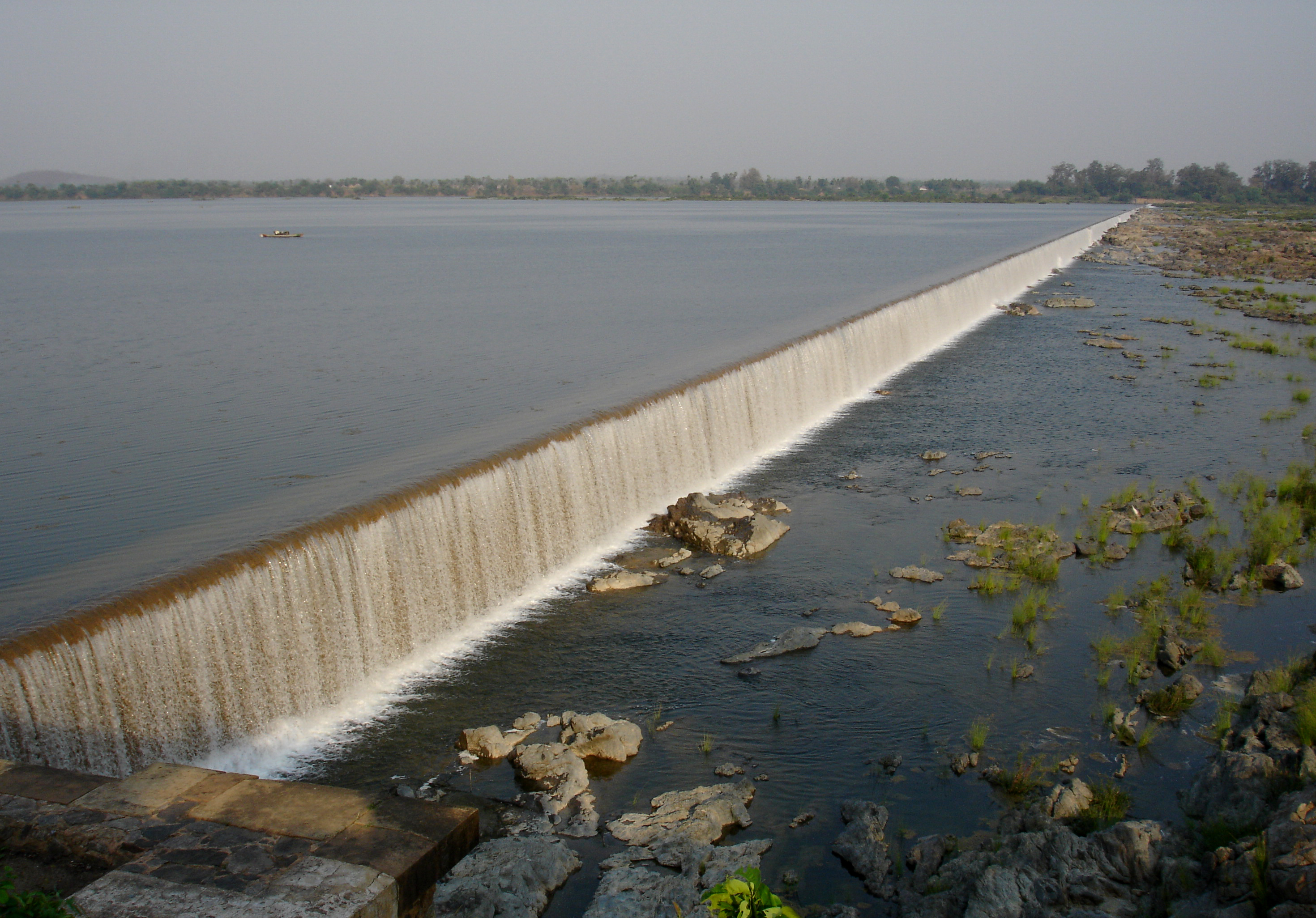

Dummugudem Barrage on River Godavari in Khammam District
History[]
Khammam town which was the seat of Taluk Administration was a part of the larger Warangal district, till 1 October 1953. Six taluks of the Warangal district viz., Khammam, Madhira, Yellandu, Paloncha, Kothagudem and Burgampadu were carved out as a new district with Khammam as headquarters.
In 1959 Bhadrachalam Revenue Division consisting of Bhadrachalam and Nuguru Venkatapuram Taluks of East Godavari district, which were on the other side of the river Godavari were merged into Khammam on grounds of geographical contiguity and administrative viability. Aswaraopeta was also part of West Godavari District up to 1959. In 1973 a new taluk with Sathupalli as headquarters was carved out from Madhira and Kothagudem taluks. In the year 1976 three new taluks were formed viz., Tirumalayapalem, Aswaraopeta and Manuguru by bifurcating Khammam, Kothagudem and Burgampadu taluks respectively.
In the year 1985, following the introduction of the Mandal system, the district has been divided into 46 mandals, under four Revenue Divisions - Khammam, Kothagudem, Paloncha and Bhadrachalam.
In the event of Telangana state formation Bhadrachalam Revenue Division (Wazedu, Charla, Venkatapuram, Dummugudem, Kunavaram, Bhadrachalam, Vara Ramachandrapuram and Chinturu Mandals) will be transferred to parent district East Godavari and Aswaraopeta Mandal will also be merged with West Godavari.
Geography[]
Khammam district occupies an area of approximately 16,029 square kilometres (6,189 sq mi),[9] comparatively equivalent to Canada's Bathurst Island.[10]
Economy[]
In 2006 the Indian government named Khammam one of the country's 250 most backward districts (out of a total of 640).[11] It is one of the thirteen districts in Andhra Pradesh currently receiving funds from the Backward Regions Grant Fund Programme (BRGF).[11]
Agriculture[]
Khammam District is endowed with Agro climatic and soil conditions in which a wide range of horticulture crops like mango, banana, cashew, coconut, oil palm, cocoa, pepper etc. are grown. Production and distribution of various kinds of fruits, vegetables and flowers and their seeds are the major activities supported by the horticulture Department.
Irrigation projects include:
- Major projects
- Nagarjunasagar Project channels
- Medium Projects
- Wyra
- Thaliperu
- Bayyaram
- Bathupally
- Lankasagar
- Mukamamidi
- Pedawagu
- Palair reservoir
Household indicators[]
In 2007–2008 the International Institute for Population Sciences interviewed 1258 households in 38 villages across the district.[12] They found that 85.8% had access to electricity, 92.2% had drinking water, 32.1% toilet facilities, and 28.6% lived in a pucca (permanent) home.[12] 33.6% of girls wed before the legal age of 18[13] and 81.7% of interviewees carried a BPL card.[12]
Image Gallery[]
")
")
")
_in_Kinnarsani_WS,_AP_W_IMG_5726.jpg "Garuga pinnata (Kakad) in Kinnarsani WS, AP W IMG 5726.jpg (168 KB)")
")
")
")
")
")
Divisions[]
Administratively Khammam district is divided into four revenue divisions and 46 mandals.
- Aswapuram
- Aswaraopeta
- Bayyaram
- Bhadrachalam
- Bonakal
- Burgampadu
- Chandrugonda
- Chintakani
- Chintoor
- Cherla
- Dammapeta
- Dummugudem
- Enkoor
- Julurpadu
- Garla
- Gundala
- Kalluru
- Kamepalli
- Karepalli
- Khammam (Urban)
- Khammam (Rural)
- Kusumanchi
- Konijerla
- Kothagudem
- Kukkunoor
- Kunavaram
- Madhira
- Manuguru
- Mudigonda
- Mulakalapalli
- Nelakondapalli
- Paloncha
- Penuballi
- Pinapaka
- Sathupalli
- Singareni
- Tallada
- Thallachervu
- Tekulapalli
- Tirumalayapalem
- Vararamachandrapuram
- Velerupadu
- Vemsoor
- Venkatapuram
- Wazedu
- Wyra
- Yellandu
- Yerrupalem
Demographics[]
According to the 2011 census Khammam district has a population of 2,798,214,[14] roughly equal to the nation of Jamaica[15] or the US state of Utah.[16] This gives it a ranking of 140th in India (out of a total of 640).[14] The district has a population density of 175 inhabitants per square kilometre (450 /sq mi) .[14] Its population growth rate over the decade 2001-2011 was 8.5%.[14] Khammam has a sex ratio of 1010 females for every 1000 males,[14] and a literacy rate of 65.46%.[14]
The density of population has grown from 51 to 160 per km². Among the population, there are about 3,60,154 Scheduled Castes 5,58,958 Scheduled Tribes. About 80% of the population lives in rural areas. The sex ratio is 974 females for every 1000 male population in rural areas and about 977 females for 1000 males in the urban areas.
The tradition and culture of Khammam district is a conglomeration of mosaic culture representing Hindus, Muslims and Christians. There are sizable number of scheduled tribes, who constitute an integral part of Hindu community. Among the tribes, Koyas and Lambadas are in domination. These tribal people still follow their own traditions and customs in their social life.
Khammam district is the largest tribal populated district in Andhra Pradesh followed by Adilabad district.
Tribals[]
The Khammam district has a tribal population of 5,58,958, which is about 13.29% of the total tribal population of the state, Andhra Pradesh.
Koyas[]
The meaning of Koya is “a good person living on the hills”. Koyas constitute about 80% of the tribal population living in the Dandakaranya forests. In general, Koyas are short statured, lean and rather diffident. They speak koya language which does not have any script. They do not own much property and the crime rate in Koya communities is generally low. Alcohol consumption is permitted among both men and women.
Koyas are an ethnic tribe found in Andhra Pradesh state and confined to Godavari valley and neighbouring Malkangiri District of Orisha State and Chhatisgarh State. They are found mostly in Bhadrachalam division of Khammam District in Andhrapradesh. They speak a dialect that is part of Gond language considered to be a major Dravidian group of languages. It more or less resembles the Telugu (the official language of Andhrapradesh) language.
- Culture of Koyas
They constitute one of the indigenous schedule tribes of the State. Their native tongue is “koi” which to a great extent resembles Telugu language as they borrowed many words from Telugu. The songs, dances, music and games played by the Koyas reflect their life style and culture. They have strong spiritual [magico-religious] beliefs and consider nature as their Goddess. They term their gods and goddesses as Devaras. But many of the tribes identify themselves as Hindus and even worship Hindu Gods and Goddesses. They usually perform ceremonies (Jatara) of the martyrs who laid down their lives for a [tribal] cause; they adore them as their spiritual heroes. Sammakka and Saaralamma are of such sort. The regard for them, probably, has led to the genesis of this jatara. Dance and songs start from there. The Koyas have an interesting dance form in which the men tie buffalo or bison horns on their heads, wear traditional costumes and beat large sized drums, while the women wearing traditional costumes dance prettily in a circular formation with their hands clasped with each other. These are popularly known as real songs, as they normally start with the expression real real real real real rerela…. In any ceremony whether it is death or marriage meat and homemade liquor consumption are very widely prevalent. Normally chicken or Mutton is served, but even beef consumption is very high. Among Koyas, some years ago-may be a decade ago men would attire only in a loin cloth (a small piece of cloth to cover their genitals), except that they would not wear anything. Women would attire themselves in saris but the way they would wear them was entirely different from the way the ladies of non-tribal communities wear. Even now some old women who stick to old tradition would wear the sari in the same fashion. But as they came in contact with the other communities, there is a gradual change in their life style. They to a great extent, discarded they old lifestyle and try to look like other communities. Even the government is taking measures to bring about faster development among them. In spite of all these measures, even now, most of them are poor and only a small percentage of population has achieved economic prosperity. Christian missionaries are very active in these tribal areas and converted a large number of tribals. They even translated Bible into Koi language and are preaching them.
- Livelihood
The livelihood of Koyas is mainly agriculture though they would do Podu, (i.e. slash and burn technique) and collect the local forest produce like tamarind, emblics, honey, Palm kernels and tender tamarind leaves. Even some of these things are a rare sight nowadays, as there is large scale deforestation. Now they no longer carry out Podu, as the forest cover has already dwindled. Most of these tribes own small land holdings and thanks to ITDA (Integrated Tribal Development Agency) Bhadrachalam; they started using modern methods in agriculture like the usage of HYV seeds, Pesticides, Fertilizers and Power sprays. So they gave up their traditional organic forming and went modern. With the passage of time, the wildlife habitat dwindled and the productivity of the land decreased due to deforestation and non-tribal settlements. The ethnic agriculture has given place for modern agriculture, with high-yielding varieties replacing the traditional ones. The culture and tradition of Koyas suffered a great deal in the process of modernization. They domesticate animals like pigs, oxen, goat and birds like fowls. These animals constitute the food items which give them protein.
- Recreation
Hunting is one of the favorite recreations of the Koya people. They use lethal bows and arrows to hunt animals, but as it has already been mentioned the forest cover decreased to a great extent and all the wild animals were hunted down and eaten up. So they consider going on hunting a sheer waste of time. As they adopted modern life style, watching movies has become their main recreation. Scores of palm trees which are termed as toddy trees are found in the vicinity of tribal hamlets and the koya tribes men extract a whitish sap from these trees. It is a popular intoxicant which is widely consumed by them. They even consume homemade liquor. The usage of these intoxicants show lot of adverse impact on their health and as a result, their life expectancy esp. men is low.
- Language
The people of Koya tribe speak a language called Koi or Koya. Though the origins of Koya community is still obscure they are said to be the members of the great Gond community of Dravidian family. So Koya language is considered to be a dialect of gond language. Even in the Koi language there are some variants. A small town called Chintoor not far away from Bhadrachalam, is considered to be the linguistic centre of Koi language and the language spoken by them is considered to be the finest variant of the language. Koi language does not have many words. Its Lexicon is very much limited. The most important reason might be the Koyas, being primitive tribes were mainly hunter gatherers. Their day to day activities were very limited. They were in no need of a sophisticated language like English which has Lakhs of words and can support the formation of a wide range of expressions. Since these tribes lead a very simple and austere life they have very small number of their own genuine, native words. So there is a strong link between the language they speak and their life style. For example being hunter gatherers they have their own words to refer to trees, animals, weapons, food etc. This language does not have a script and Telugu script is commonly used to write this language. A government sponsored programme called Rajeev Vidya Mission has prepared some text books from class I to class V with the intention of imparting education to tribal children in their mother tongue. All those books are written in Telugu script.
Konda Reddis[]
Konda Reddis live in thick forests on high mountains. They speak an ancient dialect of Telugu. In general, they are reserved in behaviour and often do not trust people from the plains. They are good craftsmen, who use Bamboo to make a variety of items.
Lambadas[]
They are also called Sugalies or Banjaras. They are often dressed in colourful clothes which are studded with mirrors, beads and other decorative items. Men wear head turbans and many sport thick moustache.In entire Khammam District Manga puram is the largest gram panchayathi which is having cent percent lambadas.
References[]
- ^ http://bezawada.com/bez/information/elections/mandalwisepopulation.asp?cname=Khammam
- ^ A Descriptive and Historical Account of the Godavery District in the Presidency of Madras, H. Morris, 1878, London, p. 216
- ^ A manual of the Kistna district in the presidency of Madras, Gordon Mackenzie, 1883, Madras, p. 25, 80
- ^ Buddhist remains in Āndhra and the history of Āndhra between 224 & 610 A.D., K. R. Subramanian, p. 149
- ^ A Handbook for India, Part I, Madras, John Murray, 1859, London
- ^ The Geography of India, J. Burgess, 1871, London, p. 48
- ^ The Church Missionary Intelligencer,Volume 2,1866, London, p. 73
- ^ "83 districts under the Security Related Expenditure Scheme". IntelliBriefs. 2009-12-11. http://intellibriefs.blogspot.com/2009/12/naxal-menace-83-districts-under.html. Retrieved 2011-09-17.
- ^ Srivastava, Dayawanti et al. (ed.) (2010). "States and Union Territories: Andhra Pradesh: Government". India 2010: A Reference Annual (54th ed.). New Delhi, India: Additional Director General, Publications Division, Ministry of Information and Broadcasting (India), Government of India. pp. 1111–1112. ISBN 978-81-230-1617-7.
- ^ "Island Directory Tables: Islands by Land Area". United Nations Environment Program. 1998-02-18. http://islands.unep.ch/Tiarea.htm. Retrieved 2011-10-11. "Bathurst Island 16,042"
- ^ a b Ministry of Panchayati Raj (September 8, 2009). "A Note on the Backward Regions Grant Fund Programme". National Institute of Rural Development. http://www.nird.org.in/brgf/doc/brgf_BackgroundNote.pdf. Retrieved September 27, 2011.
- ^ a b c "District Level Household and Facility Survey (DLHS-3), 2007-08: India. Andhra Prades" (PDF). International Institute for Population Sciences and Ministry of Health and Family Welfare. 2010. http://www.rchiips.org/pdf/rch3/report/AP.pdf. Retrieved 2011-10-03.
- ^ "How Do I? : Obtain Marriage Certificate". National Portal Content Management Team, National Informatics Centre. 2005. http://india.gov.in/howdo/howdoi.php?service=3. Retrieved 2011-10-03. "To be eligible for marriage, the minimum age limit is 21 for males and 18 for females."
- ^ a b c d e f "District Census 2011". Census2011.co.in. 2011. http://www.census2011.co.in/district.php. Retrieved 2011-09-30.
- ^ US Directorate of Intelligence. "Country Comparison:Population". https://www.cia.gov/library/publications/the-world-factbook/rankorder/2119rank.html. Retrieved 2011-10-01. "Jamaica 2,868,380 July 2011 est"
- ^ "2010 Resident Population Data". U. S. Census Bureau. http://2010.census.gov/2010census/data/apportionment-pop-text.php. Retrieved 2011-09-30. "Utah 2,763,885"
External links[]
- Official website
 Khammam district travel guide from Wikivoyage


| |||||||||||||||||
Template:Cities and towns in Khammam district Template:Godavari basin
| This page uses content from the English language Wikipedia. The original content was at Khammam district. The list of authors can be seen in the page history. As with this Familypedia wiki, the content of Wikipedia is available under the Creative Commons License. |