| ||||||||||||||
| Bankura district বাঁকুড়া জেলা |
|
|---|---|
| — District of West Bengal — | |
 |
|
| Country | India |
| State | West Bengal |
| Administrative division | Burdwan |
| Established | |
| Headquarters | Bankura |
| Government | |
| • Lok Sabha constituencies | Bankura, Bishnupur (SC) - both with assembly segments in adjoining districts |
| • Assembly seats | Saltora, Chhatna, Ranibandh, Raipur, Taldangra, Bankura, Barjora, Onda, Bishnupur, Katulpur, Indas, Sonamukhi |
| Area | |
| • Total | 6,882 km2 (2,657 sq mi) |
| Population (2011) | |
| • Total | 35,96,292 |
| • Density | 520/km2 (1,400/sq mi) |
| • Urban | 235,264 |
| Demographics | |
| • Literacy | 70.95 per cent[1] |
| • Sex ratio | 914 |
| Major highways | NH 60 |
| Average annual precipitation | 1,400 mm |
| Website | Official website |
Bankura district (Pron: bʌnˈkʊrə or bænˈkʊrə or bãˈkʊrə) (Bengali: বাঁকুড়া জেলা) is one of the seven districts of Burdwan Division in the Indian state of West Bengal. The district has been described as the “connecting link between the plains of Bengal on the east and Chota Nagpur plateau on the west.” The areas to the east and north-east are low lying alluvial plains. To the west the surface gradually rises, giving way to undulating country, interspersed with rocky hillocks.[2]
Centre of the famous Malla kingdom of western Bengal, Bankura and its surrounding regions are identified with its historical and cultural significance for the later period of Middle Ages. Vaishnavism, which gained the status of state religion of the Malla kingdom in seventeenth century AD, shaped the culture of the region. The Malla Kingdom was annexed by British East India Company in 1765 and the modern Bankura district took its form in 1881 and was named after its headquarters.
Etymology[]
There are different opinions about the etymology of the word Bankura. In the language of the Kol-Mundas, orah or rah means habitation. Banku means extremely beautiful. It may also have come from the word banka which means zig-zag. One of the most influential deities in the district is Dharmathakur and he is locally called Bankura Roy.[3] According to local tradition, the town, which is presently the head quarters of the district was named after its founder, a chieftain named Banku Rai. Another legend has it the town was named after Bir Bankura, one of the twenty-two sons of Bir Hambir, the Raja of Bishnupur. He divided his kingdom into twenty-two tarafs or circles and gave one to each son. Taraf Jaybelia fell to the lot of Bir Bankura. He developed the town that now bears the name Bankura. It has also been suggested that the name is a corruption of the word Bankunda, meaning five tanks. The name Bacoonda is found in old official records.[2]
History[]
The earliest signs of human habitation in the area was at Dihar. By about 1000 BC chalcolithic people had settled on the north bank of the Dwarakeswar.[4]
Bankura district which was inhabited by various Proto-Australoid and a few Proto-Dravidian tribes in later pre-historic times was Aryanised or assimilated with the people and culture of the Proto-Indo-European group, who prevailed in northern India, substantially later than rest of Bengal, over many centuries, and was achieved through both conflict and cordiality.
The district was part of Rarh in ancient times. In the Aitareya Aranyaka (around 7th century BC) the people of the region have been referred to as asuras (demons). In the old Jain book Acaranga Sutra (around 4th century) there is mention of Sumha and Ladha (Rarh?) and there too the reference is to an area inhabited by uncivilised and barbaric people.[5][6]
In the 4th century, it is learnt from the Susunia edicts, in Prakrit and Sanskrit, that Chandravarman, son of Simhavarman, was ruler Pushkarana (modern Pokhanna in Bankura district).[7] According to the inscription on the Allahabad pillar Chandravarman was defeated by Samudragupta and the area became a part of the Gupta Empire.[8] The area was for many years part of Dandabhukti and Bardhamanbhukti.[9]
Many historians opine that assimilation with Proto-Indo-Europeans took place first in northern and eastern Bengal and then in western Bengal. This has also been the broad course of the spread of Buddhism and Jainism in Bengal. There is ample evidence of pre-eminence of Aryan religion and culture in West Bengal from around 6th century.[5]
Bishnupur kingdom[]

Dalmadal cannon at Bishnupur, commissioned by the Malla kings
From around 7th century till around the advent of British rule, for around a millennium, history of Bankura district is identical with the rise and fall of the Hindu Rajas of Bishnupur.[10] The area around Bishnupur was called Mallabhum. At its farthest extent Bishnupur kingdom stretched from Damin-i-koh in Santhal Parganas to Midnapore and included parts of Bardhaman and Chota Nagpur. Smaller kingdoms of aboriginal tribes, such as Dhalbhum, Tungbhum, Samantabhum and Varahabhumi or Varabhumi were gradually subdued and overshadowed by the Malla kings of Bishnupur.[10]
Adi Malla (born 695 AD), the founder of the Malla dynasty, ruled in Laugram, 8.4 kilometres (5.2 mi) from Kotulpur, for 33 years. When he was 15 tears old he had no equal as a wrestler in the territory all around. It was this that earned him the sobriquet of Adi Malla, the original or unique wrestler. He was known as the Bagdi Raja. He was succeeded by his son, Jay Malla, who extended his domains and shifted his capital to Bishnupur. The subsequent kings steadily extended their kingdom. Among the more renowned are: Kalu Malla, Kau Malla, Jhau Malla, and Sur Malla.
[]
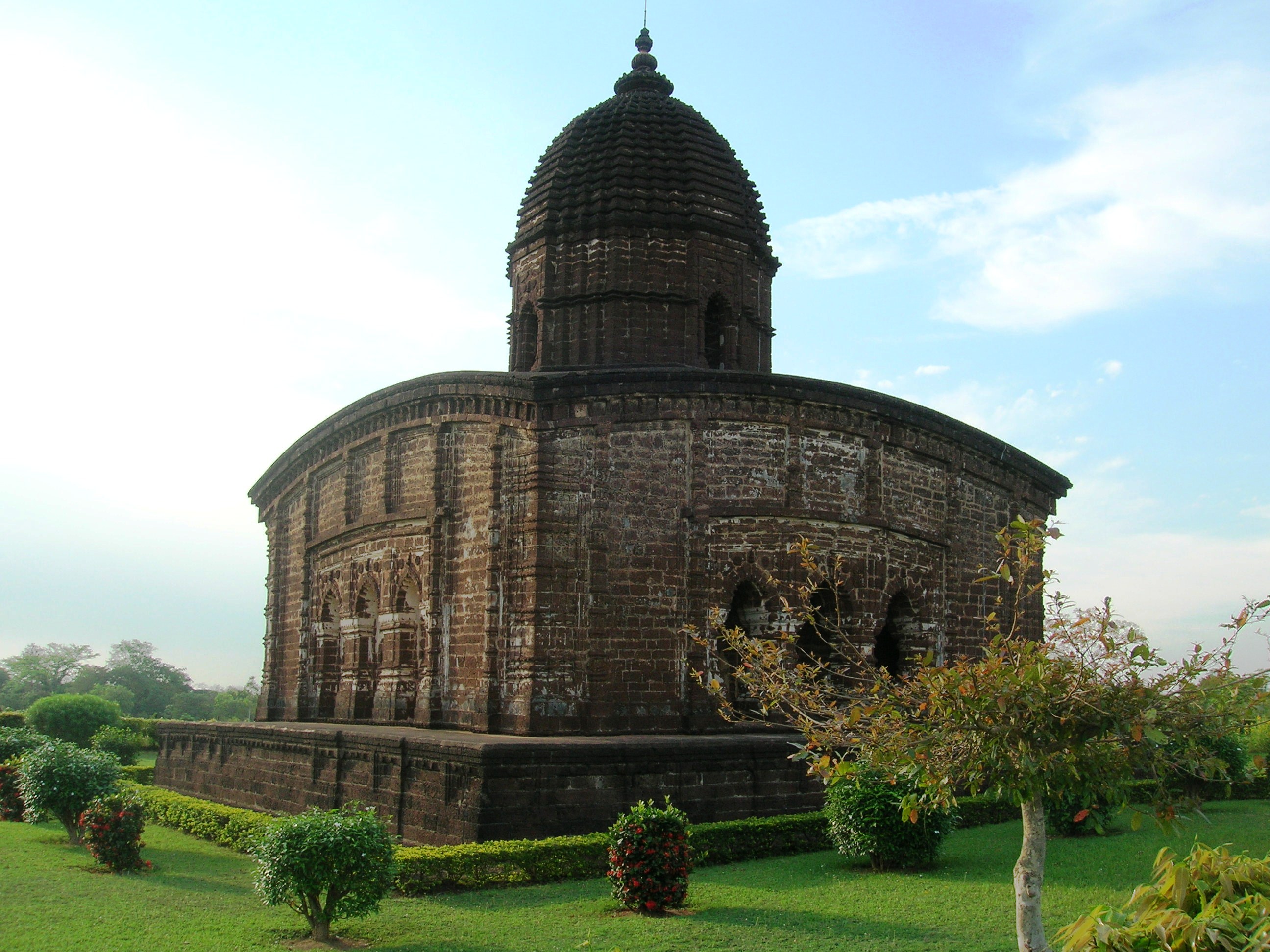
Jor Mandir complex (c. 1726), Bishnupur
Bir Hambir, the 49th ruler of the Malla dynasty who flourished around 1586 AD and ruled in 16th-17th century, was a contemporary of the Mughal emperor Akbar. He was involved on the side of Mughals in their struggle against the Afghans and is mentioned by Muslim historians. He paid an annual tribute to the Muslim viceroys of Bengal and thus acknowledged their suzerainty. He was converted to Vaishnavism by Srinivasa and introduced the worship of Madan Mohan in Bishnupur.[10]
Raghunath Singh, who followed Bir Hambir, was the first Bishnupur Raja to use the Kshatriya title Singh. With exquisite palaces and temples built during the period that followed Bishnupur was reputed to be the most renowned city in the world, more beautiful than the house of Indra in heaven. However, it has also been recorded that while these royal patrons of Hindu art and religion were busy building temples they had lost much of their independence and sunk to the position of tributary princes. Bir Singh walled up alive all his sons, eighteen in number. The youngest, Durjan, alone escaped, having been kept in hiding by the servants. The status of the Raja of Bishnupur was that of a tributary prince, exempted from personal attendance at the court at Murshidabad, and represented there by a resident.[10]
Maratha raids[]
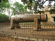
Dalmadal Canon
The Bishnupur Rajas who were at the summit of their fortunes towards the end of the 17th century, started declining in the first half of the 18th century. First, the Maharaja of Burdwan seized the Fatehpur Mahal, and then the Maratha invasions laid waste their country. In 1742, when the Marathas, under Bhaskar Rao, attacked Bishnupur, the troops put up a spirited defence but then Gopal Singh retreated within the fort and ordered the troops and citizens to pray to Madan Mohan to save the city. It is believed that Madan Mohan responded and the cannons were fired without human assistance. The truth probably is that the Maratha cavalry were unable to pierce the strong fortifications and retired. While they failed to take the fort and pillage the treasury, the Marathas harried the less protected parts of the kingdom. Intrigue and litigation that followed ruined the Bishnupur Raj family and eventually in 1806, the estate was sold for arrears of land revenue and bought up by the Maharaja of Burdwan.[10]
British administration[]
Bishnupur was ceded to the British with the rest of Burdwan chakla in 1760. The Marathas had laid the country waste and famine of 1770 completed the misery of the kingdom. A large section of the population was swept away, cultivation fell, and lawlessness spread. The once powerful king had been reduced to the status of a mere zamindar. In 1787, Bishnupur was united with Birbhum to form a separate administrative unit, the headquarters was shifted to Suri, and a rebellious situation prevailed. Bankura continued to be one district with Birbhum till 1793, when it was transferred to the Burdwan collectorate.[10]
Towards the end of the 18th century, certain portions of the district around Raipur was affected by the Chuar rebellion. At the time Bankura appears to have been part of Jungle Mahals. The disturbances of the Chuars in 1832 in the western part of the district lead to the disbandment of the Jungle Mahals in 1833. Bishnupur was transferred to Burdwan. In 1872, the parganas of Sonamukhi, Indas, Kotulpur, Shergarh and Senpahari were transferred from Manbhum to Burdwan. In 1879, the district acquired its present shape with the thanas of Khatra and Raipur and the outpost of Simplapal being transferred from Manbhum, and the thanas of Sonamukhi, Kotulpur and Indas being retransferred from Burdwan. However, it was known for sometime as West Burdwan and in 1881 came to be known as Bankura district.[10]
Post-independence[]
The district is currently a part of the Red Corridor.[11]
Geography[]
Bankura district is a part of Burdwan Division. It is situated between 22° 38’ and 23° 38’ north latitude and between 86° 36’ and 87° 46’ east longitude. It has an area of 6,882 square kilometres (2,657 sq mi). On the north and north-east the district is bounded by Bardhaman district, from which it is separated mostly by the Damodar River. On the south-east it is bounded by Hooghly district, on the south by Paschim Medinipur district and on the west by Purulia district.[2][12][13] Bankura district has been described as the “connecting link between the plains of Bengal on the east and Chota Nagpur plateau on the west.” The areas to the east and north-east are low lying alluvial plains, similar to predominating rice lands of Bengal. To the west the surface gradually rises, giving way to undulating country, interspersed with rocky hillocks. Much of the country is covered with jungles.[2]
The western part of the district has poor, ferruginous soil and hard beds of laterite with scrub jungles and sal woods. Long broken ridges with irregular patches of more recent alluvium have marks of seasonal cultivation. During the long dry season large extents of red soil with hardly any trees lend the country a scorched and dreary appearance. In the eastern part the eye constantly rests on wide expanses of rice fields, green in the rains but parched and dry in summer.[2]
The Gondwana system is represented in the northern portion of the district, south of the Damodar, between Mejia and Biharinath Hill. The beds covered with alluvium contains seams of coal belonging to the Raniganj system.[2]
Hills and rivers[]


Susunia hills
The hills of the district consist of outliers of the Chota Nagpur plateau and only two are of any great height – Biharinath and Susunia. While the former rises to a height of 448 metres (1,470 ft), the latter attains a height of 440 metres (1,440 ft).[2]
The rivers of the area flow from the north-east to the south-west in courses roughly parallel to one another. They are mostly hill streams, originating in the hills in the west. The rivers come down in floods after heavy rains and subside as rapidly as they rise. In summer, their sand beds are almost always dry. The principal rivers are: Damodar, Dwarakeswar, Shilabati, Kangsabati, Sali, Gandheswari, Kukhra, Birai, Jaypanda and Bhairabbanki. There are some small but picturesque water falls along the course of the Shilabati near Harmasra, and along the course of the Kangsabati in the Raipur area.[2]
Kangsabati Project was started during the second five year plan period (1956–1961). The dam across the Kangsabati has a length of 10,098 metres (33,130 ft) and a height of 38 metres (125 ft).[14]
Climate[]
The climate, especially in the upland tracts to the west, is much drier than in eastern or southern Bengal. From the beginning of March to early June, hot westerly winds prevail, the thermometer in the shade rising to around 45 °C (113 °F). The monsoon months, June to September, are comparatively pleasant. The total average rainfall is 1,400 millimetres (55 in), the bulk of the rain coming in the months of June to September. Winters are pleasant with temperatures dropping down to below 27 °C (81 °F) in December.[2]
Economy[]
In 2006 the Ministry of Panchayati Raj named Bankura one of the country's 250 most backward districts (out of a total of 640).[15] It is one of the nineteen districts in West Bengal currently receiving funds from the Backward Regions Grant Fund Programme (BRGF).[15]
Divisions[]
Admninistrative divisions[]
The district comprises three subdivisions: Bankura Sadar, Khatra and Bishnupur. Bankura Sadar subdivision consists of Bankura municipality and eight community development blocs: Bankura — I, Bankura — II, Barjora, Chhatna, Gangajalghati, Mejia, Onda and Shaltora. Khatra subdivision consists of eight community development blocs: Indpur, Khatra, Hirbandh, Raipur, Sarenga, Ranibandh, Simlapal and Taldangra. Bishnupur subdivision consists of Bishnupur and Sonamukhi municipalities and six community development blocks: Indas, Joypur, Patrasayar, Kotulpur, Sonamukhi and Bishnupur.[16]
Bankura is the district headquarters. There are 21 police stations, 22 development blocks, 3 municipalities, 190 gram panchayats and 5187 villages in this district.[16][17]
Other than municipality area, each subdivision contains community development blocs which in turn are divided into rural areas and census towns. In total there are 5 urban units: 3 municipalities and 2 census towns.[17][18]
Assembly constituencies[]
The district is divided into 13 assembly constituencies (assembly constituency numbers in brackets):[19] Taldangra (244), Raipur (ST) (245), Ranibandh (ST) (246), Indpur (SC) (247), Chhatna (248), Gangajalghati (SC) (249), Barjora (250), Bankura (251), Onda (252), Vishnupur (253), Kotulpur (254), Indas (SC) (255) and Sonamukhi (SC) (256).
Raipur and Ranibandh constituencies are reserved for Scheduled Tribes (ST) candidates. Indpur, Gangajalghati, Indas and Sonamukhi constituencies are reserved for Scheduled Castes (SC) candidates. Taldangra, Raipur, Ranibandh, Indpur, Vishnupur, Kotulpur and Indas constituencies are part of Vishnupur (Lok Sabha constituency), which is reserved for Scheduled Castes (SC). Chhatna, Bankura and Onda are assembly segments of Bankura (Lok Sabha constituency), which also contains four assembly segments from Purulia district. Gangajalghati, Barjora and Sonamukhi constituencies are part of Durgapur (Lok Sabha constituency), which also contains four assembly segments from Bardhaman district.
As per order of the Delimitation Commission in respect of the delimitation of constituencies in the West Bengal, the district will be divided into 12 assembly constituencies (assembly constituency numbers in brackets):[20] Saltora (SC) (247), Chhatna (248), Ranibandh (ST) (249), Raipur (ST) (250), Taldangra (251), Bankura (252), Barjora (253), Onda (254), Bishnupur (255), Katulpur (SC) (256), Indas (SC) (257) and Sonamukhi (SC) (258).
Raipur and Ranibandh constituencies will be reserved for Scheduled Tribes (ST) candidates. Saltora, Katulpur, Indas and Sonamukhi constituencies will be reserved for Scheduled Castes (SC) candidates. Saltora, Chhatna, Ranibandh, Raipur, Taldangra, and Bankura constituencies will be part of Bankura (Lok Sabha constituency), which will also contain one assembly segment from Purulia district. Barjora, Onda, Bishnupur, Katulpur, Indas and Sonamukhi will be assembly segments of Bishnupur (Lok Sabha constituency), which also contains one assembly segments from Bardhaman district.
Demographics[]
According to the 2011 census Bankura district has a population of 3,596,292,[21] roughly equal to the nation of Lithuania[22] or the US state of Connecticut.[23] This gives it a ranking of 80th in India (out of a total of 640).[21] The district has a population density of 523 inhabitants per square kilometre (1,350 /sq mi) .[21] Its population growth rate over the decade 2001-2011 was 12.64%.[21] Bankura has a sex ratio of 954 females for every 1000 males,[21] and a literacy rate of 70.95%.[21]
In the 2001 census, Bankura district had a total population of 3,191,822 of which 1,634,561 were males and 1,557,261 were females. Decadal growth for the period 1991-2001 was 13.79% in Bankura district against 17.84% in West Bengal. The urban population was 235,264 against a rural population of 2,956,558. The district had a density of population of 464 persons per km2.[13] The district had a scheduled caste population of 1,040,297 and a scheduled tribe population of 335,047.[24]
The first census was taken in 1872. The district as now constituted had a population of 968,597. In the 1901 census, 90.7 per cent of the population spoke a dialect of Bengali known as Rarhi Boli, which was also spoken in the adjoining districts. Santali was spoken by about 9 per cent of the population. 87.4 per cent of the population were Hindus, 8 per cent were Animists and 5.6 per cent were Muslims.[25] Bankura has a literacy rate of 63.84 per cent.[26]
Culture[]
Places of interest[]


Mukutmanipur dam
Bankura is the headquarters of the district. Bishnupur (or Vishnupur) is a subdivisional town of Bankura district. It was the capital of the Mallabhum kingdom, once the most important Hindu dynasty in Bengal. This town famous for the Terracotta Temples made by the local red soils. This city oftern called as the 'Temple City' of Bengal.
Susunia hills and Beharinath hills are located in the district. Mukutmonipur dam and Sutan are notable tourist spots. Gouripur leprosy hospital is Asia's largest leprosy hospital. Mejia power plant is the only thermal power plant of this district. Darakaswar, Gandheaswari and Kansabati are the major rivers flow through the district. Jaipur forest is the only forest in the plains of Southern Bengal. Bankura Sammilani Medical College is the oldest medical college in this area.
Flora and fauna[]
The eastern portion of the district forms part of the rice plains of West Bengal. The land under rice cultivation contains the usual marsh weeds of Gangetic plain. Aquatic plants and water weeds are found in ponds, ditches and still streams. Around human habitations there are shrub species such as Glycosmis, Polyalthia suberosa, Clerodenaron infortunatum, Solanum torvum, and various other species of the same genus, besides Trema, Streblus and Ficus hispida. The larger trees are papal, banyan, red cotton tree (Bombax malabaricum), mango (Mangifera indica), jiyal (Odina Wodier), Phoenix dactylifera, and Borassus flabellifer. Other plants found include Jatropha gossypifolia, Urena, Heliotropium and Sida. Forests or scrub jungles contain Wendlandia exserta, Gmelina arborea, Adina Cordifolia, Holarrhena antidysenterica, Wrightia tomentosa, Vitex negundo and Stephegyne parvifolia.[27]
The western portion of the district is higher. The uplands either bare or are covered with scrub jungle of Zizyphus and other thorny shrubs. This thorny forest gradually merges into sal (Shorea robusta) forest. Low hills are covered with Miliusa, Schleichera, Diospyros and other trees.[27]
Some of the common trees of economic interest found in the district are: Alkushi (Mucuna pruriens), amaltas (Cassia Fistula), asan (Terminaliatomentosa), babul (Acacia Arabica), bair (Zizyphus Jujuba), bael (Aegle Marmelos), bag bherenda (Jatropha curcas), bichuti (Tragia involucrate), bahera (Terminalia belerica), dhatura (Datura stramonium), dhaman (Cordia Macleoidii), gab (Diospyros Embyopteris), harra (Terminalia chebula), imli (Tamarindus indica), kuchila (Strychnos Nux vomica), mahua (Bassia latifolia), palas (Butea frondosa), sajina (Moringa pterygosperma), kend (Diospyros melanoxylon), mango, date-palm, nim, papal, banyan, red cotton tree and jiyal.[27]
References[]
- ^ "District-specific Literates and Literacy Rates, 2001". Registrar General, India, Ministry of Home Affairs. http://www.educationforallinindia.com/page157.html. Retrieved 2010-10-10.
- ^ a b c d e f g h i O’Malley, L.S.S., ICS, Bankura, Bengal District Gazetteers, pp. 1-20, first published 1908, 1995 reprint, Government of West Bengal
- ^ "Wecome to Historical Details of Bankura". Origin of Name. www.bankura,org. http://www.bankura.org/site/History.htm. Retrieved 2009-07-11.
- ^ Das, Dipak Ranjan. "Dihar". Banglapedia. Asiatic Society of Bangladesh. http://banglapedia.search.com.bd/HT/D_0226.htm. Retrieved 2009-07-12.
- ^ a b Ghosh, Binoy, Paschim Banger Sanskriti, (in Bengali), part I, 1976 edition, pp. 60-62, pp. 328-331, Prakash Bhaban
- ^ Ray, Nihar Ranjan, Bangalir Itihas Adi Parba, (in Bengali), 1980 edition, pp. 276-281, Paschim Banga Niraksharata Durikaran Samiti
- ^ Majumdar, R.C., History of Ancient Bengal, pp. 32, 444, Tulshi Prakashani.
- ^ Sengupta, Nitish, History of the Bengali-speaking People, p.21, UBS Publishers’ Distributors Pvt. Ltd.
- ^ Ghosh, Binoy, Paschim Banger Sanskriti, (in Bengali), part I, 1976 edition, pp. 82-86, Prakash Bhaban
- ^ a b c d e f g O’Malley, L.S.S., ICS, Bankura, Bengal District Gazetteers, pp. 21-46, 1995 reprint, Government of West Bengal
- ^ "83 districts under the Security Related Expenditure Scheme". IntelliBriefs. 2009-12-11. http://intellibriefs.blogspot.com/2009/12/naxal-menace-83-districts-under.html. Retrieved 2011-09-17.
- ^ "Bankura, West Bengal". Location and extent. District administration. http://bankura.gov.in/Location/location.htm. Retrieved 2009-07-11.
- ^ a b "Provisional population totals, West Bengal, Table 4, Bankura District". Census of India 2001. Census Commission of India. http://web.cmc.net.in/wbcensus/DataTables/02/Table4_13.htm. Retrieved 2009-07-12.
- ^ "Sankhipta Bharatkosh". abasar.net. http://www.abasar.net/bk_main.asp?what=B00053. Retrieved 2009-06-15.
- ^ a b Ministry of Panchayati Raj (September 8, 2009). "A Note on the Backward Regions Grant Fund Programme". National Institute of Rural Development. http://www.nird.org.in/brgf/doc/brgf_BackgroundNote.pdf. Retrieved September 27, 2011.
- ^ a b "Directory of District, Sub division, Panchayat Samiti/ Block and Gram Panchayats in West Bengal, March 2008". West Bengal. National Informatics Centre, India. 2008-03-19. http://wbdemo5.nic.in/writereaddata/Directoryof_District_Block_GPs(RevisedMarch-2008).doc. Retrieved 2008-12-06.
- ^ a b "Administrative Features". Official website of Bankura district. http://bankura.gov.in/Profile/administrative_features.htm. Retrieved 2008-12-06.
- ^ "Population, Decadal Growth Rate, Density and General Sex Ratio by Residence and Sex, West Bengal/ District/ Sub District, 1991 and 2001". Bankura. Directorate of census operations, West Bengal. http://bankura.gov.in/Census/PCA/Table-1.xls. Retrieved 2008-12-06.
- ^ "General election to the Legislative Assembly, 2001 – List of Parliamentary and Assembly Constituencies". West Bengal. Election Commission of India. http://archive.eci.gov.in/se2001/background/S25/WB_ACPC.pdf. Retrieved 2008-11-14.
- ^ "Delimitation Commission Order No. 18". Table B – Extent of Parliamentary Constituencies. Government of West Bengal. http://ceowestbengal.nic.in/news_pdf/gazette123.pdf. Retrieved 2009-05-27.
- ^ a b c d e f "District Census 2011". Census2011.co.in. 2011. http://www.census2011.co.in/district.php. Retrieved 2011-09-30.
- ^ US Directorate of Intelligence. "Country Comparison:Population". https://www.cia.gov/library/publications/the-world-factbook/rankorder/2119rank.html. Retrieved 2011-10-01. "Lithuania 3,535,547 July 2011 est."
- ^ "2010 Resident Population Data". U. S. Census Bureau. http://2010.census.gov/2010census/data/apportionment-pop-text.php. Retrieved 2011-09-30. "Connecticut 3,574,097"
- ^ "TRU for all Districts (SC & ST and Total)". Census 2001. Census Commission of India. http://web.cmc.net.in/wbcensus/HouseListingF/SCST/All_distSCST(TRU1)13.htm. Retrieved 2009-07-12.
- ^ O’Malley, L.S.S., pp. 48-52
- ^ "District Industrial Potential Report of Bankura (2003-04)". http://sisikolkata.gov.in/dipsr_bankura.htm. Retrieved 2010-07-21.
- ^ a b c O’Malley, L.S.S., pp. 12-15
External links[]
| Wikisource has the text of the 1911 Encyclopædia Britannica article Bankura. |
 Bankura travel guide from Wikivoyage

|
Bardhaman district |
| ||
| Purulia district | Hooghly district | |||
 Bankura district | ||||
| West Midnapore district |
| |||||
| ||||||||
Template:Bankura topics
| This page uses content from the English language Wikipedia. The original content was at Bankura district. The list of authors can be seen in the page history. As with this Familypedia wiki, the content of Wikipedia is available under the Creative Commons License. |