| ||||||||||||||
| Martin County, North Carolina | |
 Historic Martin County Courthouse in Williamston.
| |
 Location in the state of North Carolina | |
 North Carolina's location in the U.S. | |
| Founded | 1774 |
|---|---|
| Named for | Josiah Martin |
| Seat | Williamston |
| Largest town | Williamston |
| Area - Total - Land - Water |
462 sq mi (1,197 km²) 461 sq mi (1,194 km²) 0.3 sq mi (1 km²), 0.06% |
| Population - (2020) - Density |
22,031 47.2/sq mi (18/km²) |
| Congressional district | 1st |
| Time zone | Eastern: UTC-5/-4 |
| Website | www.martincountyncgov.com |
Martin County is a county located in the U.S. state of North Carolina. As of the 2020 census, the population was 22,031.[1] Its county seat is Williamston.[2]
History[]
The county was formed in 1774 from the southeastern part of Halifax County and the western part of Tyrrell County. It was named for Josiah Martin, the last royal governor of North Carolina (1771–75).[3] Whereas Dobbs County and Tryon County, named for Martin's predecessors Arthur Dobbs and William Tryon, were abolished after American independence, Martin County was neither abolished nor renamed, a fact which has been attributed to the popularity of Alexander Martin, twice governor of the state (1782–84, 1789–92).
The Martin County Courthouse was listed on the National Register of Historic Places in 1979.[4]
Geography[]
According to the U.S. Census Bureau, the county has a total area of 462 square miles (1,200 km2), of which 461 square miles (1,190 km2) is land and 0.3 square miles (0.78 km2) (0.06%) is water.[5]
State and local protected areas/sites[]
- Fort Branch Confederate Earthen Fort Civil War Site
- Foxtale Hunting Preserve
- Gardiners Creek
- Lower Roanoke River Wetlands Game Land
- Jamesville Wildlife Preserve
- Moratoc Park
- Multiple parks within or close to Robersonville and Williamston
Adjacent counties[]
- Bertie County – northeast
- Washington County – east
- Beaufort County – southeast
- Pitt County – southwest
- Edgecombe County – west
- Halifax County – northwest
Major water-bodies[]
- Conoho Creek
- Etheridge Creek
- Gum Swamp
- Hardison Mill Creek
- Long Creek
- Reedy Branch
- Roanoke River
- Smithwick Creek
- Tranters Creek
- Welch Creek
Major highways[]
- [[Template:Infobox road/NC/link I-Future|Template:Infobox road/NC/abbrev I-Future]] (Concurrency with US-64 and US-17)
 US 13
US 13- US 17
- US 64
- US 64 Alt.
- NC 11
- NC 42
- NC 111
- NC 125
- NC 142
- NC 171
- NC 903
Other major infrastructure[]
- Marin County Airport
Demographics[]
| Historical populations | |||
|---|---|---|---|
| Census | Pop. | %± | |
| 1790 | 6,010 | ||
| 1800 | 5,629 | −6.3% | |
| 1810 | 5,987 | 6.4% | |
| 1820 | 6,320 | 5.6% | |
| 1830 | 8,539 | 35.1% | |
| 1840 | 7,637 | −10.6% | |
| 1850 | 8,307 | 8.8% | |
| 1860 | 10,195 | 22.7% | |
| 1870 | 9,647 | −5.4% | |
| 1880 | 13,140 | 36.2% | |
| 1890 | 15,221 | 15.8% | |
| 1900 | 15,383 | 1.1% | |
| 1910 | 17,797 | 15.7% | |
| 1920 | 20,828 | 17.0% | |
| 1930 | 23,400 | 12.3% | |
| 1940 | 26,111 | 11.6% | |
| 1950 | 27,938 | 7.0% | |
| 1960 | 27,139 | −2.9% | |
| 1970 | 24,730 | −8.9% | |
| 1980 | 25,948 | 4.9% | |
| 1990 | 25,078 | −3.4% | |
| 2000 | 25,593 | 2.1% | |
| 2010 | 24,505 | −4.3% | |
| U.S. Decennial Census[6] 1790–1960[7] 1900–1990[8] 1990–2000[9] 2010–2020[10] | |||
2020 census[]
| Race | Number | Percentage |
|---|---|---|
| White (non-Hispanic) | 11,528 | 52.33% |
| Black or African American (non-Hispanic) | 8,868 | 40.25% |
| Native American | 69 | 0.31% |
| Asian | 98 | 0.44% |
| Pacific Islander | 1 | 0.0% |
| Other/Mixed | 572 | 2.6% |
| Hispanic or Latino | 895 | 4.06% |
As of the 2020 United States census, there were 22,031 people, 9,378 households, and 6,195 families residing in the county.
2000 census[]
As of the census[12] of 2000, there were 25,593 people, 10,020 households, and 7,194 families residing in the county. The population density was 56 people per square mile (21/km2). There were 10,930 housing units at an average density of 24 per square mile (9/km2). The racial makeup of the county was 52.54% White, 45.37% Black or African American, 0.29% Native American, 0.24% Asian, 0.03% Pacific Islander, 0.90% from other races, and 0.63% from two or more races. 2.06% of the population were Hispanic or Latino of any race.
There were 10,020 households, out of which 31.60% had children under the age of 18 living with them, 50.30% were married couples living together, 17.60% had a female householder with no husband present, and 28.20% were non-families. 25.70% of all households were made up of individuals, and 11.90% had someone living alone who was 65 years of age or older. The average household size was 2.53 and the average family size was 3.02.
In the county, the population was spread out, with 25.50% under the age of 18, 7.50% from 18 to 24, 26.80% from 25 to 44, 25.00% from 45 to 64, and 15.20% who were 65 years of age or older. The median age was 39 years. For every 100 females there were 86.50 males. For every 100 females age 18 and over, there were 81.80 males.
The median income for a household in the county was $28,793, and the median income for a family was $35,428. Males had a median income of $29,818 versus $19,167 for females. The per capita income for the county was $15,102. About 16.30% of families and 20.20% of the population were below the poverty line, including 27.50% of those under age 18 and 25.70% of those age 65 or over.
Law and government[]
Martin County is a member of the Mid-East Commission regional council of governments.
Politics[]
Martin County is a historically Democratic county; in 2004, it voted Republican for only the fourth time, the first three having been in the Republican landslides of 1872, 1972, and 1984. Barack Obama won the county back for the Democratic Party in both 2008 and 2012, but in 2016, it narrowly backed Donald Trump. In 2020, it supported Trump again, voting for a losing Republican nominee for the first time ever, this time giving him an outright majority of the vote.[13]
| Year | Republican | Democratic | Third party | |||
|---|---|---|---|---|---|---|
| No. | % | No. | % | No. | % | |
| 2020 | 6,532 | 52.09% | 5,911 | 47.14% | 97 | 0.77% |
| 2016 | 5,897 | 49.29% | 5,846 | 48.86% | 221 | 1.85% |
| 2012 | 5,995 | 47.38% | 6,583 | 52.03% | 74 | 0.58% |
| 2008 | 5,957 | 47.50% | 6,539 | 52.14% | 45 | 0.36% |
| 2004 | 5,334 | 51.03% | 5,102 | 48.81% | 16 | 0.15% |
| 2000 | 4,420 | 47.19% | 4,929 | 52.63% | 17 | 0.18% |
| 1996 | 3,590 | 41.98% | 4,500 | 52.62% | 462 | 5.40% |
| 1992 | 2,958 | 36.90% | 4,069 | 50.76% | 989 | 12.34% |
| 1988 | 3,149 | 46.61% | 3,598 | 53.26% | 9 | 0.13% |
| 1984 | 4,266 | 52.32% | 3,870 | 47.47% | 17 | 0.21% |
| 1980 | 2,564 | 34.59% | 4,750 | 64.09% | 98 | 1.32% |
| 1976 | 1,931 | 29.81% | 4,518 | 69.75% | 28 | 0.43% |
| 1972 | 4,188 | 68.76% | 1,840 | 30.21% | 63 | 1.03% |
| 1968 | 1,221 | 14.97% | 3,118 | 38.22% | 3,818 | 46.81% |
| 1964 | 1,511 | 23.86% | 4,821 | 76.14% | 0 | 0.00% |
| 1960 | 737 | 11.23% | 5,826 | 88.77% | 0 | 0.00% |
| 1956 | 449 | 7.27% | 5,730 | 92.73% | 0 | 0.00% |
| 1952 | 415 | 7.02% | 5,493 | 92.98% | 0 | 0.00% |
| 1948 | 163 | 3.36% | 4,636 | 95.53% | 54 | 1.11% |
| 1944 | 133 | 2.93% | 4,408 | 97.07% | 0 | 0.00% |
| 1940 | 106 | 2.24% | 4,628 | 97.76% | 0 | 0.00% |
| 1936 | 111 | 2.42% | 4,477 | 97.58% | 0 | 0.00% |
| 1932 | 94 | 2.42% | 3,781 | 97.37% | 8 | 0.21% |
| 1928 | 411 | 12.73% | 2,818 | 87.27% | 0 | 0.00% |
| 1924 | 216 | 9.71% | 1,999 | 89.88% | 9 | 0.40% |
| 1920 | 530 | 17.15% | 2,561 | 82.85% | 0 | 0.00% |
| 1916 | 281 | 16.03% | 1,472 | 83.97% | 0 | 0.00% |
| 1912 | 229 | 15.13% | 1,251 | 82.63% | 34 | 2.25% |
| 1908 | 421 | 23.93% | 1,338 | 76.07% | 0 | 0.00% |
| 1904 | 216 | 13.21% | 1,419 | 86.79% | 0 | 0.00% |
| 1900 | 1,088 | 37.43% | 1,819 | 62.57% | 0 | 0.00% |
| 1896 | 1,374 | 44.98% | 1,681 | 55.02% | 0 | 0.00% |
| 1892 | 1,091 | 38.56% | 1,454 | 51.40% | 284 | 10.04% |
| 1888 | 1,308 | 44.03% | 1,663 | 55.97% | 0 | 0.00% |
| 1884 | 1,250 | 44.42% | 1,564 | 55.58% | 0 | 0.00% |
| 1880 | 1,287 | 47.76% | 1,408 | 52.24% | 0 | 0.00% |
Education[]
The primary and secondary public school functions are performed by Martin County Schools, a district covering the entire county. Martin Community College is located in Williamston.
Notable people[]
- Annie Moore Cherry
- Wilber Hardee, founder of Hardee's
- William Drew Robeson I, minister of Witherspoon Street Presbyterian Church
Communities[]

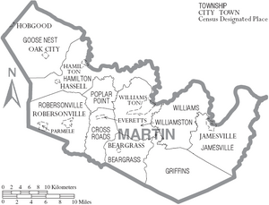
Map of Martin County, North Carolina With Municipal and Township Labels
Towns[]
- Bear Grass
- Everetts
- Hamilton
- Hassell
- Jamesville
- Oak City
- Robersonville
- Williamston (county seat and largest town)
Townships[]
- Bear Grass
- Cross Roads
- Goose Nest
- Griffins
- Hamilton
- Jamesville
- Poplar Point
- Robersonville
- Williams
- Williamston
See also[]
- National Register of Historic Places listings in Martin County, North Carolina
- List of future Interstate Highways
- North Carolina in the American Civil War
References[]
- ^ "U.S. Census Bureau QuickFacts: Martin County, North Carolina" (in en). https://www.census.gov/quickfacts/fact/table/martincountynorthcarolina/PST045221.
- ^ "Find a County". National Association of Counties. http://www.naco.org/Counties/Pages/FindACounty.aspx.
- ^ Gannett, Henry (1905). The Origin of Certain Place Names in the United States. U.S. Government Printing Office. p. 201. https://archive.org/details/bub_gb_9V1IAAAAMAAJ.
- ^ "National Register Information System". National Register of Historic Places. National Park Service. 2010-07-09. http://nrhp.focus.nps.gov/natreg/docs/All_Data.html.
- ^ "2010 Census Gazetteer Files". United States Census Bureau. August 22, 2012. https://www.census.gov/geo/maps-data/data/docs/gazetteer/counties_list_37.txt.
- ^ "U.S. Decennial Census". United States Census Bureau. https://www.census.gov/programs-surveys/decennial-census.html.
- ^ "Historical Census Browser". University of Virginia Library. http://mapserver.lib.virginia.edu.
- ^ Forstall, Richard L., ed (March 27, 1995). "Population of Counties by Decennial Census: 1900 to 1990". United States Census Bureau. https://www.census.gov/population/cencounts/nc190090.txt.
- ^ "Census 2000 PHC-T-4. Ranking Tables for Counties: 1990 and 2000". United States Census Bureau. April 2, 2001. https://www.census.gov/population/www/cen2000/briefs/phc-t4/tables/tab02.pdf.
- ^ "State & County QuickFacts". United States Census Bureau. http://quickfacts.census.gov/qfd/states/36/36117.html.
- ^ "Explore Census Data". https://data.census.gov/cedsci/table?g=0500000US37117&tid=DECENNIALPL2020.P2.
- ^ "U.S. Census website". United States Census Bureau. https://www.census.gov.
- ^ "County winners, 1836-2016" (in en-US). https://docs.google.com/spreadsheets/d/1ZmDRzvm83BYurKX7LsrET-C7tcIsE5Em42Wt-gTydXk/edit?usp=embed_facebook.
- ^ Leip, David. "Dave Leip's Atlas of U.S. Presidential Elections". http://uselectionatlas.org/RESULTS.
External links[]
- NCGenWeb Martin County – free genealogy resources for the county

|
Halifax County | Bertie County |
| |
| Edgecombe County | Washington County | |||
 Martin County, North Carolina | ||||
| Pitt County | Beaufort County |
| |||||||||||

|
| This page uses content from the English language Wikipedia. The original content was at Martin County, North Carolina. The list of authors can be seen in the page history. As with this Familypedia wiki, the content of Wikipedia is available under the Creative Commons License. |