| Te Ika-a-Māui (Māori) | |
|---|---|
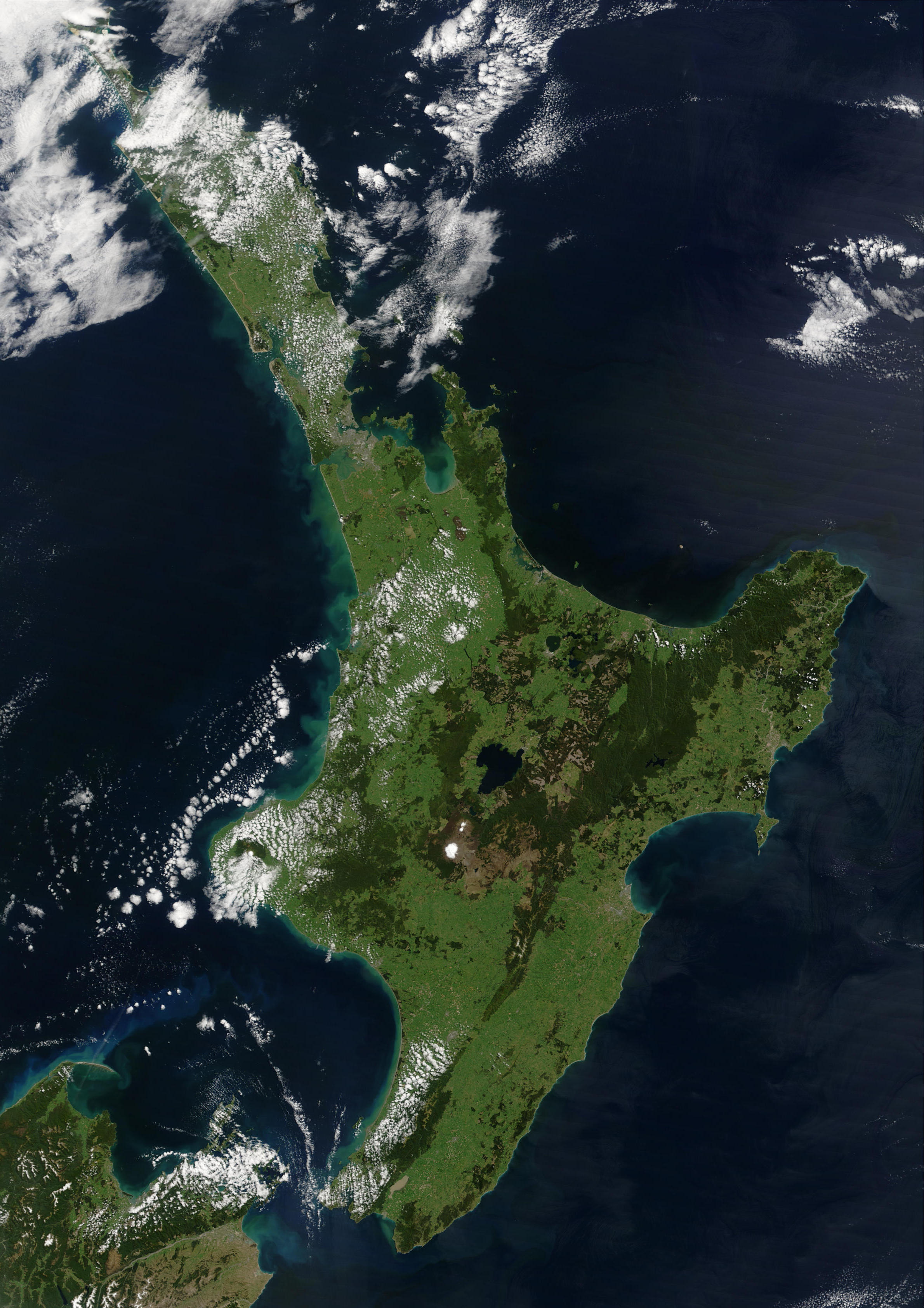 Satellite image of the North Island | |
|
[[file:Template:Location map Oceania|220px|North Island is located in Template:Location map Oceania]]
<div style="position: absolute; top: Expression error: Unrecognized punctuation character "[".%; left: Expression error: Unrecognized punctuation character "[".%; height: 0; width: 0; margin: 0; padding: 0;"><div style="position: relative; text-align: center; left: -Expression error: Unrecognized punctuation character "[".px; top: -Expression error: Unrecognized punctuation character "[".px; width: Template:Location map Oceaniapx; font-size: Template:Location map Oceaniapx; line-height: 0;" title="">[[File:Template:Location map Oceania|Template:Location map OceaniaxTemplate:Location map Oceaniapx|North Island|link=|alt=]] <div style="font-size: 90%; line-height: 110%; position: relative; top: -1.5em; width: 6em; Expression error: Unrecognized punctuation character "[".">North Island (Oceania) | |
| Geography | |
| Location | Oceania |
| Coordinates | |
| Archipelago | New Zealand |
| Area | 113,729 km2 (43,911 sq mi) |
| Area rank | 14th |
| Highest elevation | 2,797 m (9,177 ft) |
| Highest point | Mount Ruapehu |
| Country | |
|
New Zealand | |
| ISO 3166-2:NZ | NZ-N |
| Regions | 9 |
| Territorial authorities | 43 |
| Largest city | Auckland (pop. 1,397,300) |
| Demographics | |
| Population | 3,393,900 (as of June 2012 estimate+) |
| Density | 29.8 /km2 (77.2 /sq mi) |
The North Island or Te Ika-a-Māui is one of the two main islands of New Zealand, separated from the slightly larger but much less populous South Island by Cook Strait. The island is 113,729 square kilometres (43,911 sq mi) in area,[1] making it the world's 14th-largest island. It has a population of 3,393,900 (June 2012 estimate).[2]
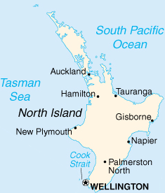
Twelve main urban areas (half of them officially cities) are in the North Island. Listing from north to south, they are Whangarei, Auckland, Hamilton, Tauranga, Rotorua, Gisborne, New Plymouth, Napier, Hastings, Whanganui, Palmerston North, and Wellington, the capital, located at the south-west extremity of the island. Approximately 77% of New Zealand's population lives in the North Island.
Naming and usage[]
Although the island has been known as the North Island for many years,[3] in 2009 the New Zealand Geographic Board found that, along with the South Island, the North Island had no official name.[4] After a public consultation, the board officially named the island North Island or Te Ika-a-Maui in October 2013.[5]
In prose, the two main islands of New Zealand are called the North Island and the South Island, with the definite articles. It is normal to use the preposition in rather than on, for example "Hamilton is in the North Island", "my mother lives in the North Island". Maps, headings, tables and adjectival expressions use North Island without the.
Māori mythology[]
According to Māori mythology, the North and South Islands of New Zealand arose through the actions of the demigod Māui. Māui and his brothers were fishing from their canoe (the South Island) when he caught a great fish and pulled it from the sea. While he was not looking his brothers fought over the fish and chopped it up. This great fish became the North Island and thus a Māori name for the North Island is Te Ika-a-Māui (The Fish of Māui). The mountains and valleys are believed to have been formed as a result of Māui's brothers' hacking at the fish. Until the early 20th Century, an alternative Māori name for the North Island was Aotearoa. In present Māori usage, Aotearoa is a collective name for New Zealand as a whole.
Economy[]
The sub-national GDP of the North Island was estimated at US$102.863 billion in 2003, 79% of New Zealand's national GDP.[6]
Ecology[]
The North Island is divided into two ecoregions within the Temperate broadleaf and mixed forests Biome; the northern part being the Northland temperate kauri forest, and the southern part being the North Island temperate forests. The island has an extensive flora and bird population, with numerous National Parks and other protected areas.
Regions of the North Island[]
Nine local government regions cover the North Island and all its adjacent islands and territorial waters.
- Northland
- Auckland
- Waikato
- Bay of Plenty
- Gisborne
- Taranaki
- Manawatu-Wanganui
- Hawkes Bay
- Wellington
Cities and towns in the North Island[]
The North Island has a larger population than the South Island with both the country's largest city, Auckland as well as the capital, Wellington at either ends of the island.
Map of the North Island showing some of its cities
| Urban areas of the North Island by population | ||||||||||
|---|---|---|---|---|---|---|---|---|---|---|
| City/Town | Region | Population (2008) | City/Town | Region | Population (2008) | |||||
| 1 | Auckland | Auckland | 1,397,300 | 11 | Wanganui | Manawatu-Wanganui | 39,500 | |||
| 2 | Wellington | Wellington | 395,600 | 12 | Kapiti Coast | Wellington | 38,900 | |||
| 3 | Hamilton | Waikato | 209,300 | 13 | Gisborne | Gisborne | 31,100 | |||
| 4 | Tauranga | Bay of Plenty | 122,200 | 14 | Taupo | Waikato | 22,600 | |||
| 5 | Palmerston North | Manawatu-Wanganui | 83,300 | 15 | Masterton | Wellington | 20,200 | |||
| 6 | Hastings | Hawke's Bay | 66,100 | 16 | Levin | Manawatu-Wanganui | 19,550 | |||
| 7 | Napier | Hawke's Bay | 58,400 | 17 | Whakatane | Bay of Plenty | 18,700 | |||
| 8 | Rotorua | Bay of Plenty | 56,100 | 18 | Cambridge | Waikato | 15,200 | |||
| 9 | New Plymouth | Taranaki | 53,000 | 19 | Feilding | Manawatu-Wanganui | 14,450 | |||
| 10 | Whangarei | Northland | 52,500 | 20 | Tokoroa | Waikato | 13,300 | |||
Healthcare[]
Healthcare in the North Island is provided by fifteen District Health Boards (DHBs). Organised around geographical areas of varying population sizes, they are not coterminous with the Local Government Regions.
| District Health Board | District | Population |
|---|---|---|
| Northland District Health Board (Te Poari Hauora a Rohe o te Tai Tokerau) | Whangarei District, Far North District, Kaipara District | 159,160 |
| Waitemata District Health Board (Te Wai Awhina) | Auckland Region | 525,000 |
| Auckland District Health Board (Te Toka Tumai) | Auckland Region | 468,000 |
| Counties Manukau District Health Board (A Community Partnership) | Auckland Region | 490,610 |
| Waikato District Health Board (Waikato DHB) | Hamilton City, Hauraki District, Matamata-Piako District, Otorohanga District, part of Ruapehu District, South Waikato, Thames-Coromandel District, Waikato District, Waipa District, Waitomo District | 372,865 |
| Bay of Plenty District Health Board (Hauora a Toi) | Tauranga City, Western Bay of Plenty District, Whakatane District, Kawerau District, Opotiki District | 214,170 |
| Lakes District Health Board (Lakes DHB) | Rotorua District, Taupo District | 102,000 |
| Tairawhiti District Health Board (Te Mana Hauora o te Tairawhiti) | Gisborne District | 44,499 |
| Hawke's Bay District Health Board (Whakawateatia) | Napier City, Hastings District, Wairoa District, Central Hawke's Bay District, Chatham Islands | 155,000 |
| Taranaki District Health Board (Taranaki DHB) | New Plymouth District, Stratford District, South Taranaki District | 104,280 |
| Whanganui District Health Board (Whanganui DHB) | Wanganui District, Rangitikei District, part of Ruapehu District | 62,210 |
| Mid Central District Health Board (Te Pae Hauora o Ruahine o Tararua) | Palmerston North City, Horowhenua District, Manawatu District, Tararua District, part of Kapiti Coast District | 158,838 |
| Wairarapa District Health Board (Te Poari Hauora a Rohe o Wairarapa) | South Wairarapa District, Carterton District, Masterton District | 38,200 |
| Hutt Valley District Health Board (Healthy People) | Lower Hutt City, Upper Hutt City | 145,000 |
| Capital and Coast District Health Board (Upoko ki te Uru Hauora) | Wellington City, Porirua City, part of Kapiti Coast District | 270,000 |
Geographic features[]
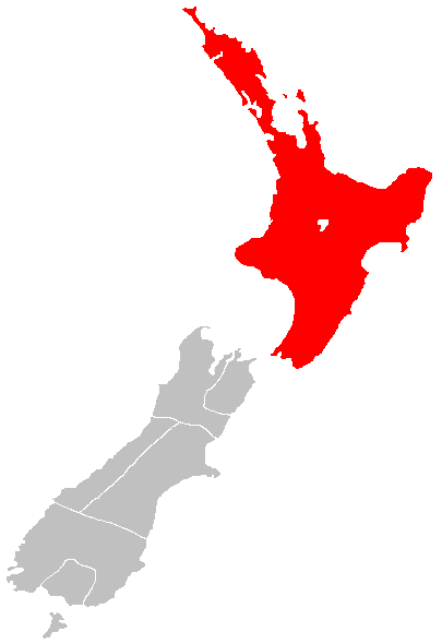
The North Island, in relation to the South Island
- Cape Reinga
- East Cape
- Cape Palliser
- Hawke Bay
- Lake Taupo
- Mt Maunganui Beach
- Tongariro National Park
- Taumatawhakatangihangakoauauotamateapokaiwhenuakitanatahu
- Waikato River
- Waipoua Kauri Forest
- Waitomo Caves
- Ninety Mile Beach
See also[]
- List of islands of New Zealand
References[]
- ^ "Quick Facts - Land and Environment : Geography - Physical Features". Statistics New Zealand. 2000. http://www2.stats.govt.nz/domino/external/web/nzstories.nsf/092edeb76ed5aa6bcc256afe0081d84e/54e50d25aff60a7bcc256b1e007adcb6?OpenDocument. Retrieved 13 August 2012.
- ^ "Subnational population estimates at 30 June 2012". Statistics New Zealand. 23 October 2012. http://www.stats.govt.nz/browse_for_stats/population/estimates_and_projections/subnational-pop-estimates-tables.aspx. Retrieved 23 October 2012. Also "Infoshare; Group: Population Estimates - DPE; Table: Estimated Resident Population for Urban Areas, at 30 June (1996+) (Annual-Jun)". Statistics New Zealand. 19 December 2012. http://www.stats.govt.nz/infoshare/SelectVariables.aspx?pxID=2f5a6aa2-7aeb-4792-a34a-d5567eb8082f. Retrieved 23 October 2012.
- ^ On some 19th-century maps, the North Island is named New Ulster, which was also a province of New Zealand that included the North Island.
- ^ "The New Zealand Geographic Board Considers North and South Island Names". Land Information New Zealand. 21 April 2009. http://www.linz.govt.nz/placenames/about-geographic-board/nzgb-news-notices/2009/0421-alternative-maori-names. Retrieved 28 November 2012.
- ^ "Two official options for NZ island names". NZ Herald. http://www.nzherald.co.nz/nz/news/article.cfm?c_id=1&objectid=11138153. Retrieved 10 October 2013.
- ^ "Regional Gross Domestic Product". Statistics New Zealand. 2007. http://www.stats.govt.nz/reports/analytical-reports/regional-gross-domestic-product.aspx. Retrieved 18 February 2010.
External links[]
| Wikivoyage has a travel guide for North Island. |
| ||||||||||||||
| This page uses content from the English language Wikipedia. The original content was at North Island. The list of authors can be seen in the page history. As with this Familypedia wiki, the content of Wikipedia is available under the Creative Commons License. |