| Main | Births etc |
|---|
| Rockdale Sydney, | |||||||||||||
 Bicentennial Park, Rockdale | |||||||||||||
| Population: | 11,588 | ||||||||||||
| Established: | 1887 | ||||||||||||
| Postcode: | 2216 | ||||||||||||
| Area: | 2.4 km² (0.9 sq mi) | ||||||||||||
| Location: | 13 km (8 mi) south of Sydney CBD | ||||||||||||
| LGA: | City of Rockdale | ||||||||||||
| State District: | Rockdale | ||||||||||||
| Federal Division: | Barton | ||||||||||||
| |||||||||||||
Rockdale is a suburb in southern Sydney, in the state of New South Wales, Australia. Rockdale is located 13 kilometres south of the Sydney central business district and is part of the St George area. Rockdale is the administrative centre for the local government area of the City of Rockdale.
History[]
Rockdale was known by Europeans as Frog Hollow, then White Gum Flat and later West Botany. West Botany Municipality was declared 13 January 1871 and had two wards, West Botany and Arncliffe. A council chambers was built in 1872 on Rocky Point Road, Arncliffe and was used until 1888 when a new building was erected on the site of the present Rockdale Town Hall, which was then demolished and rebuilt after World War 2.[1]

Rockdale Town Hall
There was a suggestion that the area become the Municipality of Scarborough but the name Rockdale was suggested by pioneer Mary Ann Geeves, postmistress and tollgate keeper and was officially adopted in 1887. Her husband, Yeoman Geeves, was a ganger on the construction of Rocky Point Road and the demolition of Cobbler's Hill (later called Arncliffe Hill). The Geeves family, including eldest son Frederick lived on the corner of today's Princes Highway and Tramway Arcade. Their general store adjoined the cottage and operated the first post office between Arncliffe and Kogarah in 1882. Residential development began with the opening of the railway in 1884. Perhaps the most significant property developer during the 1880s was Frederick Jamison Gibbes (1839–1888), a Member of Parliament, who is commemorated by Gibbes Street in Banksia. Until 1949, an electric tramway operated between Rockdale Station down Bay Street to Brighton-Le-Sands. In 1948, Rockdale and Bexley councils amalgamated as Rockdale Municipal Council. The City of Rockdale was declared in 1995.[2] The City of Rockdale has a number of sister city relationships.
Commercial area[]

Café Culture, King Street
Rockdale has a mixture of residential, commercial and light industrial areas. The main shopping strip runs along the Princes Highway, on the eastern side of Rockdale railway station. The commercial centre spreads out into surrounding streets and on the western side of the railway line. King Street has developed into a cosy strip of cafes and grocery shops. Commercial developments run along the length of theparts of Bay Street and West Botany Street. The light industrial areas are located around West Botany Street.
Rockdale Plaza, which opened in 1997, is a medium sized shopping centre located on Princes Highway. It contains two supermarkets, two discount department stores, a motor registry, a medical centre, a food court, real estate agent, sports store, electrical appliance store, video rental shop and specialty shops. It was built on the former site of the Waltons department store and tenpin bowling centre.
Rockdale Town Hall and the St George Tavern are examples of some of the Art Deco architecture in the area. The Town Hall was built in 1940 to a design by local resident and architect Douglas Gardiner.[3]
Population[]
According to the 2006 Australian Bureau of Statistics Census of Population, there were 13,901 people usually resident in Rockdale. 53.2% stated they were born overseas with the top countries of birth being China 9.5%, Macedonia 5.2%, and Bangladesh 3.7%. English was stated as the only language spoken at home by 29.9% of residents and the most common other languages spoken were Macedonian 15.7%, Mandarin 7.2% and Arabic 7.2%. The most common responses for religious affiliation were Catholic 22.8%, Orthodox 16.1% and Islam 10.1%.[4]
Politics[]
- Federal Government: Rockdale is in the Division of Barton in the Australian House of Representatives.
- State government: Rockdale is in the Electoral district of Rockdale in the New South Wales Legislative Assembly.
- Local Government: Rockdale is in the local government area of the City of Rockdale.
Transport[]

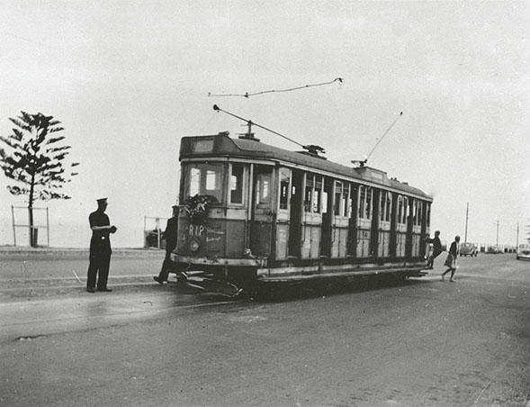
Last run to Rockdale from Brighton-Lee-Sands
The Princes Highway is the main road through Rockdale. West Botany Street, to the east, runs parallel to Princes Highway. Bay Street links Rockdale to General Holmes Drive at Brighton-le-Sands. Rockdale railway station is on the Illawarra line of the City Rail network. Rockdale is a major bus interchange for Sydney Buses government buses, which provides services to Miranda, Brighton-Le-Sands, Dulwich Hill, Burwood and Bondi Junction.
Rockdale to Brighton-Le-Sands tram line[]
This line opened as a private steam tramway in 1885. It was electrified in 1900, and moved into government ownership in 1914. The line connected with the trains at Rockdale station, then passed down Bay Street to Brighton-Le-Sands. The line was single track throughout, with a passing loop at each end. The line closed in 1949 and was replaced by a bus service. A small depot in Rockdale maintained the cars.
References[]
- ^ The Book of Sydney Suburbs, Page 223, Compiled by Frances Pollon, Angus & Robertson Publishers, 1990, Published in Australia ISBN 0-207-14495-8, page 223
- ^ Lawrence, Joan (1996). Pictorial Memories St. George: Rockdale, Kogarah, Hurstville. Australia: Kingsclear Books. ISBN 0-908272-45-6.
- ^ "BUILDING AND CONSTRUCTION.". The Sydney Morning Herald (NSW : 1842 - 1954) (NSW: National Library of Australia): p. 7. 16 January 1940. http://nla.gov.au/nla.news-article17668001. Retrieved 10 July 2012.
- ^ http://id.com.au/dosydney/Default.aspx?pg=1&gid=5200
External links[]
- Rockdale City Council website
- 2001 Census Information
- South East Health
- Rockdale Chamber of Commerce
| ||||||||
| This page uses content from the English language Wikipedia. The original content was at Rockdale, New South Wales. The list of authors can be seen in the page history. As with this Familypedia wiki, the content of Wikipedia is available under the Creative Commons License. |