| Wellington Region | |||
|---|---|---|---|
| — Region of New Zealand — | |||
|
|||
 |
|||
| Country | New Zealand | ||
| Island | North Island | ||
| Established | 1989 | ||
| Seat | Wellington | ||
| Territorial authorities | List
Wellington City
Hutt City Porirua City Upper Hutt City Kapiti Coast District South Wairarapa District Carterton District Masterton District Tararua District (part) |
||
| Government | |||
| • Chairperson | Fran Wilde | ||
| • Deputy Chairperson | Peter Glensor | ||
| Area | |||
| • Region | 8,140 km2 (3,140 sq mi) | ||
| Population (June 2012 estimate)[1] | |||
| • Region | 490,100 | ||
| • Density | 60/km2 (160/sq mi) | ||
| Time zone | NZST (UTC+12) | ||
| • Summer (DST) | NZDT (UTC+13) | ||
| Website | www.gw.govt.nz | ||
The Wellington region of New Zealand occupies the southern end of the North Island.
Governance[]
The official Wellington Region, as administered by the Wellington Regional Council (under the brand-name "Greater Wellington") covers the conurbation around the capital city, Wellington, and the cities of Lower Hutt, Porirua, and Upper Hutt, each of which also contains a rural hinterland. It extends up the west coast of the North Island, taking in the coastal settlements of the Kapiti Coast district, which includes the southern fringe of the area commonly known as Horowhenua and the town of Otaki. East of the Rimutaka Range it includes three largely rural districts containing most of Wairarapa, covering the towns of Masterton and Carterton, Greytown, Featherston and Martinborough.[2]
Regional Councillors[]
Greater Wellington Regional Council is a statutory body made up of 13 regional councillors, representing six constituencies:[2]
- Wellington has 5 representatives
- Kapiti 1
- Porirua-Tawa 2
- Lower Hutt 3
- Upper Hutt 1
- Wairarapa 1
| Function | Name | Constituency | Ticket |
|---|---|---|---|
| Chair[3] | Fran Wilde | Wellington | |
| Councillor | Chris Laidlaw | Wellington | |
| Councillor | Judith Aitken | Wellington | |
| Councillor | Paul Bruce | Wellington | Green |
| Councillor | Daran Ponter | Wellington | Labour |
| Councillor | Nigel Wilson | Kapiti | |
| Councillor | Jenny Brash | Porirua-Tawa | |
| Councillor | Barbara Donaldson | Porirua-Tawa | |
| Councillor | Sandra Greig | Lower Hutt | |
| Councillor | Peter Glensor | Lower Hutt | |
| Councillor | Prue Lamason | Lower Hutt | |
| Councillor | Paul Swain | Upper Hutt | |
| Councillor | Gary McPhee | Wairarapa |
Demographics[]
Production and income[]
The Wellington Region is by a large margin the most wealthy region in the country. The most up-to-date estimates for regional GDP prepared by the Ministry for Economic Development put the region's GDP at $17.5 billion in the year to March 2004 which was $36,700 per capita, 19% larger than the Auckland Region figure of $30,750, 38% larger than the poorest region, Northland ($26,600) and 3% more than the second highest region (Northern South Island, $35,800).[4]
At the time of the census in 2006 Wellington region recorded the largest percentages of people in all of the four highest income groupings ($40,001-$50,000: 8.9%, $50,001-$70,000: 10.5%, $70,001-$100,000: 5.9% and $100,001+: 5.2%) as well as the lowest percentage of residents in the 'loss' group (0.37%).[5] As at December 2007 people in the Wellington Region has a significantly higher average weekly income from all sources ($812/week) than other regions in New Zealand (18% more than second-place Auckland with $687/week).[6]
As of 2006, 25.8% of employed Wellingtons worked in professional occupations and 14.3% in clerical occupations, the largest percentage for each category of any region in the country. Conversely, excluding 369 people in areas not covered by an official region, Wellington has the lowest percentage of technicians and trades workers in the country (10.6%), the lowest percentage of machinery operators and drivers (4.1%) and the lowest percentage of labourers (7.1%).[5]
Ethnicity[]
Wellington Region is second only to Auckland in many statistics related to breadth of ethnicity. As of the 2006 Census, Wellington had the second-highest Asian population (8.4%, Auckland:18.9%) and the second-highest Pacific Islander population (8.0%, Auckland:14.4%). 26.1% of Wellingtonians were born outside New Zealand which is second to Auckland (40.4%).[5]
Gender[]
The Wellington Region has the second-highest percentage of women at 51.52% (Nelson:51.53%, West Coast:49.21%), particularly between the ages of 16-29, where it is at 48.86% with Otago next at 49.11% followed by Gisborne at 49.18%, contrasted with Marlborough at 52.61% for the same age group.[5]
Education[]
As of 2006, 21.1% of Wellingtonians have a degree, compared to only 6.6% on the West Coast, 17.7% for Auckland and 14.5% for Otago (though 0.97% of Otago residents have Doctorate level degrees, compared with 0.87% for Wellington). Auckland and Wellington are equal lowest for "No Qualification" at 18.1%.[5]
Transport[]
11.3% of Wellington households do not have access to a car, which is the highest for any region of the country.[5]
Telecommunications[]
Wellington statistics for mobile phone use at 76.3% is only exceeded by Auckland (76.4%) followed by Waikato (75.3%). Access to the internet is 65.5%, highest equal with Auckland, followed by Canterbury (61.3%). Somewhat surprisingly, Wellingtonians are least likely to have access to a fax machine (21.1%) after Gisborne (20.5%).[5]
Economy[]
The sub-national GDP of the Wellington region was estimated at US$19.3 billion in 2003, 15% of New Zealand's national GDP.[7]
Usage of the term Wellington region[]
The boundaries of the Wellington Region described in this article correspond to the local government region administered by Greater Wellington (the Wellington Regional Council). In common usage the terms Wellington Region and Greater Wellington are not so clearly defined and areas on the periphery of the region are often excluded.
In its more restrictive sense the Wellington Region refers only to the cluster of built-up areas west of the Tararua ranges. The much more sparsely populated area to the east has its own name, Wairarapa, and a centre in Masterton.
To a lesser extent, the Kapiti Coast is sometimes excluded from the region. Otaki, in particular, has strong connections to the Horowhenua District to the north.
Geography[]
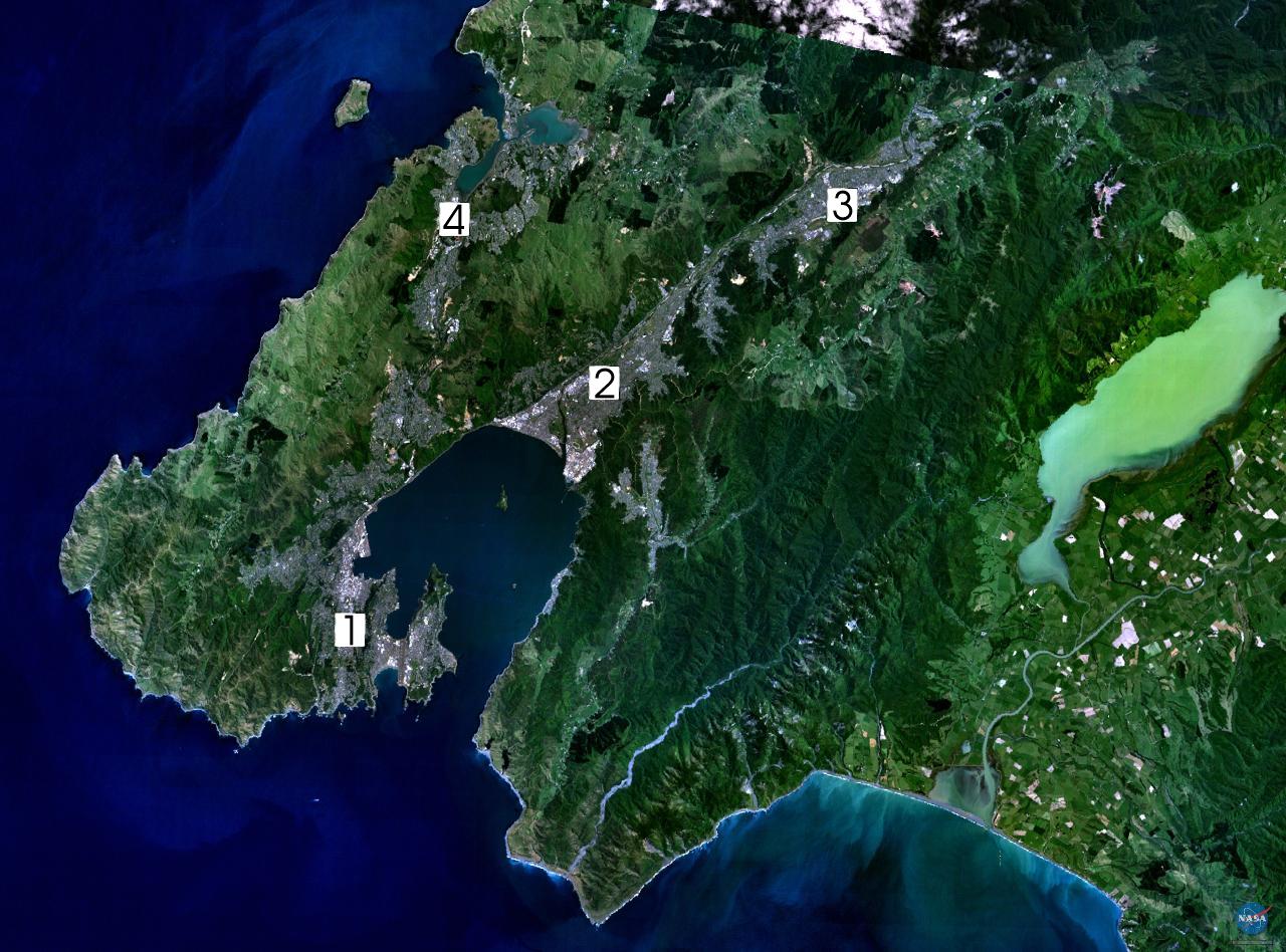
A composite landsat-7 image of the southwestern part of the Wellington Region

A map showing population density in the Wellington Region at the 2006 census
The region occupies the southern tip of the North Island, bounded to the west, south, and east by water. To the west lies the Tasman Sea and to the east the Pacific Ocean. At the southern end of the island these two bodies of water are joined by the narrow and turbulent Cook Strait, which is only 28 kilometres (17 mi) wide at its narrowest point, between Cape Terawhiti and Perano Head in the Marlborough Sounds.
The region covers 7,860 square kilometres (3,030 sq mi), and extends north to Otaki in the west and almost to Eketahuna in the east. Physically and topologically the region has four basic areas running roughly parallel to each other along a northeast-southwest axis.
The first of these four regions is a narrow coastal strip of plains running north from Paekakariki. This area, known as the Kapiti coast, contains numerous small towns, many of which gain at least a proportion of their wealth from tourism, largely due to their fine beaches.
Inland from this is rough hill country, formed along the same major geologic fault responsible for the Southern Alps in the South Island. Though nowhere near as mountainous as these, the Rimutaka and Tararua Ranges are still hard country and support only small populations, although it is in small coastal valleys and plains at the southern end of these ranges that the cities of Wellington and the Hutt Valley are located.
The third topological stripe of the region is the undulating hill country of the Wairarapa around the Ruamahanga River. This area, which becomes lower and flatter in the south, terminates in the wetlands around Lake Wairarapa and contains much rich farmland. The final section of the region's topology is another section of rough hill country, lower than the Tararuas but far less economic than the land around the Ruamahanga River. Both of the hillier striations of the region are still largely forested.
Regional parks[]
There are 5 regional parks:[8]
- Battle Hill Farm Forest Park
- Belmont Regional Park
- East Harbour Regional Park
- Kaitoke Regional Park
- Queen Elizabeth Park
Template:Wellington regional parks
History[]
The Māori who originally settled the Wellington area knew it as Te Upoko o te Ika a Māui, meaning "the head of Māui's fish". Legend recounts that Kupe discovered and explored the district in about the tenth century.
The Wellington region was settled by Europeans in 1839 by the New Zealand Company. Wellington City became the capital of Wellington Province upon the creation of the province in 1853, until the Abolition of the Provinces Act came into force on 1 Nov 1876.[9] Wellington became capital of New Zealand in 1865, the third capital of New Zealand after Auckland, and Russell.
People[]

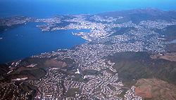
Aerial view of Wellington city
Over three-quarters of the region's 490,100 people (June 2012 estimate)[1] reside in the four cities at the southwestern corner of the region. Other main centres of population are on the Kapiti Coast and in the fertile farming areas close to the upper Ruamahanga River in the Wairarapa.
Along the Kapiti Coast, numerous small towns sit close together, many of them occupying spaces close to popular beaches. From the north, these include Otaki, Waikanae, Paraparaumu, the twin settlements of Raumati Beach and Raumati South, Paekakariki and Pukerua Bay, the last of which is a northern suburb of Porirua. Each of these settlements has a population of between 2,000 and 10,000, making this a moderately heavily populated coastline.
In the Wairarapa the largest community by a considerable margin is Masterton, with a population of almost 20,000. Other towns in the area include Featherston, Martinborough, Carterton and Greytown.
Famous sons and daughters[]
- Jane Campion – film-maker
- Russell Crowe – actor
- Peter Jackson – film-maker
- Anna Paquin – actress
- Raybon Kan – comedian
- Katherine Mansfield – writer
- Jack Marshall – former Prime Minister
- Tana Umaga – former All Black Captain
- Nancy Wake – war hero
- Michael Campbell – Winner of US Open 2005
- Pollyfilla – drag queen
- Sir Bob Charles – Professional Golfer
- Ben Hana – Blanket Man
- Jack Yan – publisher and graphic designer
- Karl Urban – actor
References[]
- ^ a b "Subnational population estimates at 30 June 2012". Statistics New Zealand. 23 October 2012. http://www.stats.govt.nz/browse_for_stats/population/estimates_and_projections/subnational-pop-estimates-tables.aspx. Retrieved 23 October 2012. Also "Infoshare; Group: Population Estimates - DPE; Table: Estimated Resident Population for Urban Areas, at 30 June (1996+) (Annual-Jun)". Statistics New Zealand. 19 December 2012. http://www.stats.govt.nz/infoshare/SelectVariables.aspx?pxID=2f5a6aa2-7aeb-4792-a34a-d5567eb8082f. Retrieved 23 October 2012.
- ^ a b "Greater Wellington Regional Council's constituencies". http://www.gw.govt.nz/section115.cfm. Retrieved 2008-05-08.
- ^ Newstalk ZB (30 October 2007). "Wilde elected Wellington regional council chair". New Zealand Herald. http://www.nzherald.co.nz/section/1/story.cfm?c_id=1&objectid=10472970&ref=rss. Retrieved 2007-10-30.
- ^ "Ministry of Economic Development Regional Economic Performance Report". 2005-11-01. http://www.med.govt.nz/templates/MultipageDocumentTOC____2315.aspx. Retrieved 2008-05-08.
- ^ a b c d e f g "2006 Census Regional Summary Tables". 2007-07-03. Archived from the original on 2007-11-24. http://web.archive.org/web/20071124230852/http://www.stats.govt.nz/NR/rdonlyres/19D6A4B9-7D98-4AF9-970D-5BBD139794CA/0/RegionalSummaryTablesRegionalCouncil.xls. Retrieved 2008-05-08.
- ^ "Nationwide Quarterly Review by Statistics New Zealand". 2008-03-25. http://www.stats.govt.nz/NR/rdonlyres/4733BC5E-9C90-461C-9BA5-5E1A9E7FC4C2/0/Dec07_NationalReview.xls. Retrieved 2008-05-08.
- ^ "Regional Gross Domestic Product". Statistics New Zealand. 2007. http://www.stats.govt.nz/reports/analytical-reports/regional-gross-domestic-product.aspx. Retrieved 18 February 2010.
- ^ Greater Wellington Parks: Draft Regional Parks Management Plan
- ^ New Zealand Provinces 1848–77
External links[]
- Semi-official map of territorial boundaries and links to their websites
- Greater Wellington
- Lists of Persons claiming to have their names inserted in one of the Electoral Rolls for Wellington/Wairarapa in 1863-64
| ||||||||||||||
| This page uses content from the English language Wikipedia. The original content was at Wellington Region. The list of authors can be seen in the page history. As with this Familypedia wiki, the content of Wikipedia is available under the Creative Commons License. |