| Main | Births etc |
|---|
| Indooroopilly Brisbane, | |||||||||||||
 Indooroopilly Shopping Centre | |||||||||||||
| Population: | 11,670 [1] | ||||||||||||
| • Density: | 1468.4/km² (3,803.1/sq mi) | ||||||||||||
| Postcode: | 4068 | ||||||||||||
| Area: | 7.5 km² (2.9 sq mi) | ||||||||||||
| Location: | 7 km (4 mi) from Brisbane GPO | ||||||||||||
| LGA: | City of Brisbane (Walter Taylor Ward) | ||||||||||||
| State District: | Indooroopilly | ||||||||||||
| Federal Division: | Ryan | ||||||||||||
| |||||||||||||
Indooroopilly /ˌɪndrəˈpɪli/ is a suburb of Brisbane, Australia 7 kilometres (4.3 mi) west of the Brisbane central business district. The suburb covers 7.5 km². At the 2011 Australian Census the suburb recorded a population of 11,670.[1]
Name derivation and history[]

1st Railway Bridge, flood damaged, Indooroopilly, 1893
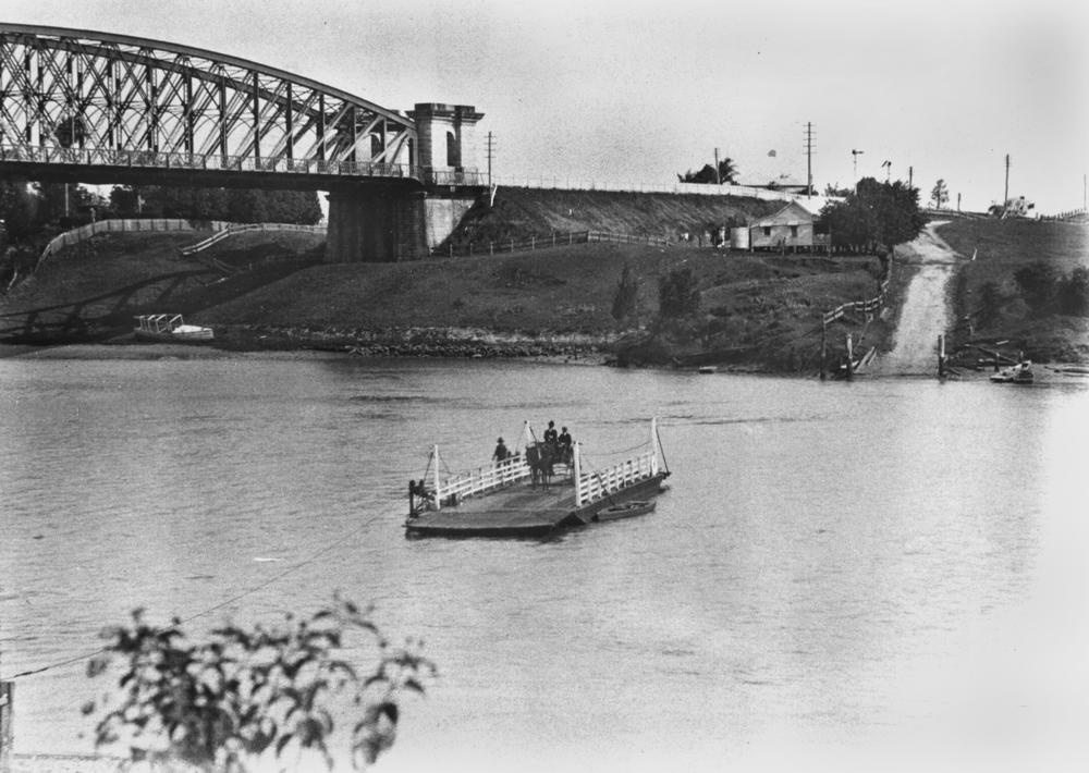
Ferry crossing, Indooroopilly, 1906


Unveiling of War Memorial, Indooroopilly, 1921


Ferry crossing and Walter Taylor Bridge under construction, Indooroopilly 1935
Indooroopilly is a corruption of either the local Aboriginal word nyindurupilli, meaning 'gully of the leeches' or yindurupilly meaning 'gully of running water'.[2] Locals often shorten the name to "Indro".
The traditional owners of the Indooroopilly area are the Aboriginal Jagera and Turrbal groups. Both groups had related languages and are classified as belonging to the Yaggera language group.
The area was first settled by Europeans in the 1860s and agriculture and dairying were common in the early years. The parish was named in the late 1850s, and the first house was built in 1861 by Mr H C Rawnsley. The arrival of rail in 1875 and completion of the Albert rail bridge across the Brisbane River to open the Ipswich rail line the following year spurred the development of Indooroopilly. The 1893 Brisbane flood destroyed the original Albert Bridge, and its replacement was opened in 1895. A lead-silver mine was established on an Indooroopilly property in 1919 and extraction continued until 1929 when the mine became unprofitable. Today the University of Queensland operates the site as an experimental mine and teaching facility for engineering students (the Julius Kruttschnitt Mineral Research Centre). The landmark Walter Taylor Bridge across the Brisbane River was completed in 1936. The first stage of Indooroopilly Shoppingtown opened in 1970.
Indooroopilly was the location for Australia's principal interrogation centre during World War II. The three interrogation cells at Witton Barracks are the only cells remaining in the country.[3]
Demographics[]
In the 2011 census, Indooroopilly had a population of 11,670 people; 50.9% female and 49.1% male.[1] The median age of the Indooroopilly population was 29 years of age, 8 years below the Australian median. The most notable difference is the group in their twenties; in Indooroopilly this group makes up 28.5% of the population, compared to 13.8% nationally. Children aged under 15 years made up 13.9% of the population and people aged 65 years and over made up 10.2% of the population. 60% of people living in Indooroopilly were born in Australia, compared to the national average of 69.8%. The other top responses for country of birth were China 3.7%, England 3.2%, New Zealand 2.5%, India 2.1%, Malaysia 1.8%. 70.4% of people spoke only English at home; the next most popular languages were 6.3% Mandarin, 2.2% Cantonese, 1.7% Arabic, 1.2% Korean, 0.9% Spanish. The most common responses for religion in Indooroopilly were No Religion 29.7%, Catholic 20.6%, Anglican 13.1%, Uniting Church 5.1% and Buddhism 3.1%.[1]
Geography[]
The suburb is designated as a regional activity centre.[4]
Attractions[]
Indooroopilly boasts significant commercial, office and retail sectors and is home to Indooroopilly Shopping Centre, the largest shopping centre in Brisbane’s western suburbs. The suburb is popular with professionals and a large number of university students from the nearby University of Queensland campus in St Lucia. The housing stock consists of a mix of detached houses and medium density apartments. There has been a trend towards increasing small lot and townhouse development in the suburb in recent years. Nevertheless, many post-war homes and iconic Queenslanders have also been restored. Brisbane City Council regulations to preserve the 'pre-war' look of Brisbane discourage destruction of many of Brisbane's Queenslanders and buildings. It is one of the Brisbane City Council's proposed Major Centres.
Transport[]
Moggill Road is the main thoroughfare, connecting Indooroopilly to Toowong and the city via Coronation Drive (inbound), and Chapel Hill and Kenmore (outbound). The Western Freeway also serves the suburb. Indooroopilly is well connected by public transport. There is a bus interchange adjoining the Indooroopilly Shopping Centre, where Brisbane Transport operates services to the CBD, university and other western suburbs. Indooroopilly railway station provides frequent services to the Brisbane CBD, Ipswich, Richlands and Caboolture.
Recreation[]
There is a café and restaurant precinct along Station Road between the shopping centre and railway station as well as to the east of the railway station. There are two cinema complexes in Indooroopilly, the Eldorado cinemas on Coonan Street and Event Cinema Megaplex inside Indooroopilly Shopping Centre. This cinema complex once had 8 cinemas, now it boasts 16. It is the major cinema complex in the Western Suburbs. Indooroopilly youth organisations include the Indooroopilly Scout Group including Rovers [5] and Indooroopilly Girl Guide District [6] Indooroopilly is also home to one of Brisbane's oldest Soccer Football Clubs, Taringa Rovers. The Indooroopilly Golf Club [7] is a 36-hole championship course offering members and guests a variety of competition and social golf.
Education[]
Indooroopilly State High School is located in the suburb. The Japanese Language Supplementary School of Queensland Japanese School of Brisbane (ブリスベン校 Burisuben Kō), a weekend Japanese school, holds its classes at Indooroopilly State High. The school offices are in Taringa.[8]
Heritage listings[]

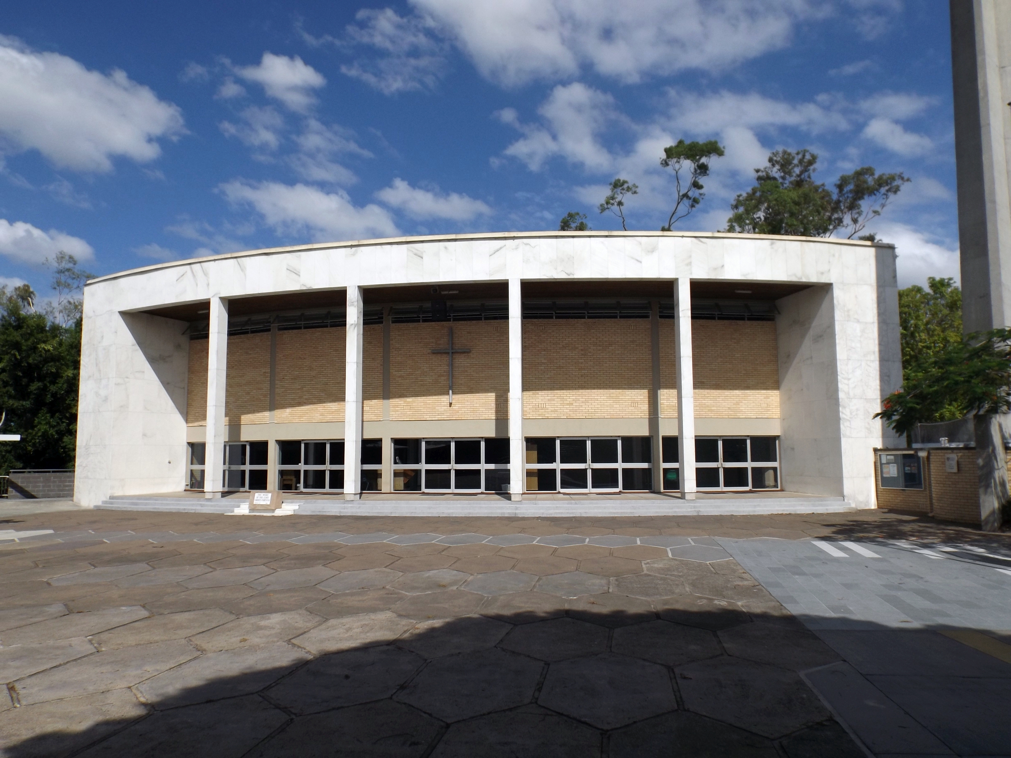
The Chapel of St Peter's Lutheran College, 2014
Indooroopilly has a number of heritage-listed sites, including:
- Brisbane River between Indooroopilly and Chelmer: Albert Bridge[9]
- Coonan Street: Walter Taylor Bridge[10]
- 10-12 Westminster Road: Keating residence[11]
- 47 Dennis Street: Greylands[12]
- 60 Harts Road: Ross Roy[13]
- 66 Harts Road: Chapel of St Peter's Lutheran College[14]
- 72 Lambert Road: St Andrews Church Hall[15]
- 203 Clarence Road: Tighnabruaich[16]
See also[]
- List of Brisbane suburbs
- Taringa Rovers Soccer Football Club
References[]
- ^ a b c d Australian Bureau of Statistics (31 October 2012). "Indooroopilly (State Suburb)". 2011 Census QuickStats. http://www.censusdata.abs.gov.au/census_services/getproduct/census/2011/quickstat/SSC30794?opendocument&navpos=220. Retrieved 11 January 2014.
- ^ "Meaning of Indooroopilly", Letter to the Editor, The Courier Mail, 28 August 1933, p.25
- ^ Tony Moore (24 July 2015). "Brisbane's top secret prison cells to be protected in bridge plan". Brisbane Times (Fairfax Media). http://www.brisbanetimes.com.au/queensland/brisbanes-top-secret-prison-cells-to-be-protected-in-bridge-plan-20150723-gijbfe.html. Retrieved 24 July 2015.
- ^ Tony Moore (9 December 2011). "Indooroopilly's future: Tall buildings, outdoor dining and possibly a new bridge". Brisbane Times (Fairfax Media). http://brisbanetimes.domain.com.au/featured-suburbs/indooroopillys-future-tall-buildings-outdoor-dining-and-possibly-a-new-bridge-20111207-1oi62.html. Retrieved 17 December 2011.
- ^ Indooroopilly Rovers (Scouts)
- ^ Indooroopilly Girl Guides
- ^ Indooroopilly Golf Club
- ^ "平成 26(2014)年度" (Archive). The Japanese Language Supplementary School of Queensland. Retrieved on 1 April 2015. p. 4. "借用校舎:インドロピリー州立高校(Indooroopilly State High School) Ward Street, Indooroopilly, QLD4068, AUSTRALIA 事務所:The Japanese Club of Brisbane/The Japanese School of Brisbane Suite 17, Taringa Professional Centre, 180 Moggill Road, Taringa, QLD4068"
- ^ "Albert Bridge (entry 15007)". Queensland Heritage Register. Queensland Heritage Council. https://heritage-register.ehp.qld.gov.au/placeDetail.html?siteId=15007. Retrieved 19 June 2013.
- ^ "Walter Taylor Bridge (entry 14956)". Queensland Heritage Register. Queensland Heritage Council. https://heritage-register.ehp.qld.gov.au/placeDetail.html?siteId=14956. Retrieved 19 June 2013.
- ^ "Keating Residence, Indooroopilly (entry 16793)". Queensland Heritage Register. Queensland Heritage Council. https://heritage-register.ehp.qld.gov.au/placeDetail.html?siteId=16793. Retrieved 19 June 2013.
- ^ "Greylands (entry 15005)". Queensland Heritage Register. Queensland Heritage Council. https://heritage-register.ehp.qld.gov.au/placeDetail.html?siteId=15005. Retrieved 19 June 2013.
- ^ "Ross Roy". Brisbane Heritage Register. Brisbane City Council. http://heritage.brisbane.qld.gov.au/heritage_register/placeDetail.do?action=read&placeId=2252. Retrieved 20 September 2014.
- ^ "Chapel of St Peter's Lutheran College, Indooroopilly (entry 32441)". Queensland Heritage Register. Queensland Heritage Council. https://heritage-register.ehp.qld.gov.au/placeDetail.html?siteId=32441. Retrieved 19 June 2013.
- ^ "St Andrews Church Hall (entry 15006)". Queensland Heritage Register. Queensland Heritage Council. https://heritage-register.ehp.qld.gov.au/placeDetail.html?siteId=15006. Retrieved 19 June 2013.
- ^ "Tighnabruaich (entry 15004)". Queensland Heritage Register. Queensland Heritage Council. https://heritage-register.ehp.qld.gov.au/placeDetail.html?siteId=15004. Retrieved 19 June 2013.
External links[]
- University of Queensland: Queensland Places: Indooroopilly
- "Indooroopilly". BRISbites. Brisbane City Council. Archived from the original on 19 July 2008. https://web.archive.org/web/20080719204143/http://www.brisbites.com/suburbView.asp?suburb=99&topic=1.
- "Indooroopilly". Our Brisbane. Brisbane City Council. Archived from the original on 14 February 2008. https://web.archive.org/web/20080214083753/http://www.ourbrisbane.com/living/suburbs/indooroopilly/home/.
- Local History - Indooroopilly
- Indooroopilly: the tongue twisting waltz song hit - virtual book. Digitised and held by State Library of Queensland.
| ||||||||||||||
| This page uses content from the English language Wikipedia. The original content was at Indooroopilly, Queensland. The list of authors can be seen in the page history. As with this Familypedia wiki, the content of Wikipedia is available under the Creative Commons License. |