| ||||||||||||||
| Jhabua district झाबुआ जिला |
|
|---|---|
| — District of Madhya Pradesh — | |
 |
|
| Country | India |
| State | Madhya Pradesh |
| Administrative division | Indore |
| Established | |
| Headquarters | Jhabua |
| Government | |
| • Lok Sabha constituencies | Ratlam |
| Area | |
| • Total | 3,782 km2 (1,460 sq mi) |
| Population (2011) | |
| • Total | 1,024,091 |
| • Density | 270/km2 (700/sq mi) |
| Demographics | |
| • Literacy | 44.45 per cent |
| • Sex ratio | 989 |
| Average annual precipitation | 800 mm |
| Website | Official website |
Jhabua district (Hindi: झाबुआ जिला) is a district of Madhya Pradesh state in central India. The town of Jhabua is the administrative headquarters of the district.
Geography[]
Jhabua district lies in the western part of Madhya Pradesh. It is surrounded by Panchmahal and Baroda districts of Gujarat, Banswara district of Rajasthan, and Alirajpur, Dhar and Ratlam districts of Madhya Pradesh.[1]
It has an area of 3,782 km2. The terrain is hilly and undulating. Average rainfall in the district is about 800 mm. The district is divided into five tehsils and six community development blocks.[1]
Jhabua district was divided into two parts in May 2008, namely Alirajpur and Jhabua. Aliarajpur, Jobat, Udaigarh, Bhabra, Sondawa and Katthiwada are the 6 blocks of new district, Alirajpur. Jhabua district now consists of Habua, Meghnagar, Ranapur, Rama, Thandla and Petlawad blocks.
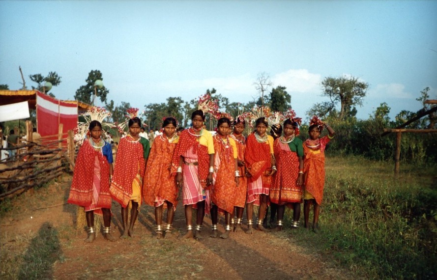
Bhil tribe girls in Jhabua district
Economy[]
The district is highly drought-prone and degraded waste lands form the matrix of Jhabua. The women make lovely ethnic items including bamboo products, dolls, bead-jewellery and other items that have for long decorated the living rooms all over the country. The men have for ages adorned "Teer-Kamthi", the bow and arrow, which has been their symbol of chivalry and self-defence.
In 2006 the Ministry of Panchayati Raj named Jhabua one of the country's 250 most backward districts (out of a total of 640).[2] It is one of the 24 districts in Madhya Pradesh currently receiving funds from the Backward Regions Grant Fund Programme (BRGF).[2]
Demographics[]
According to the 2011 census Jhabua District has a population of 1,024,091,[3] roughly equal to the nation of Cyprus[4] or the US state of Montana.[5] This gives it a ranking of 440th in India (out of a total of 640).[3] The district has a population density of 285 inhabitants per square kilometre (740 /sq mi) .[3] Its population growth rate over the decade 2001–2011 was 30.58%.[3] Jhabua has a sex ratio of 989 females for every 1000 males,[3] and a literacy rate of 44.45%.[3]
As per the 2001 census Jhabua district (considering the separation of Alirajpur) had a total population of 784,286, out of which 396,141 were males and 388,145 were females. 91 per cent of the population was rural. 85.60 per cent of the population was tribal and 3 per cent belonged to scheduled castes.[1] Before the separation of Alirajpur, Jhabua district had a sex ratio of 990 and density of population stood at 206 / km2.[6]
Jhabua is a predominantly Adivasi district, and suffers from high rates of illiteracy and poverty. Almost half of the population lives below the poverty line. The Bhil and Bhilala peoples inhabit the interior of the district.
Languages[]
Languages spoken include Bareli Rathwi, a Bhil language with approximately 64 000 speakers, written in the Devanagari script;[7] and Bhilali, with 1 150 000 speakers.[8]
Literacy[]
With a literacy rate of 36.9 per cent Jhabua district had the lowest literacy rate amongst districts of Madhya Pradesh.[9]
Culture[]
A small village of 320 people in 1971, Deojhiri is 8 km north-east of Jhabua on the Ahmedabad-Indore State Highway No.22. It is at a distance of 1 km on the western side of the road, on the Sunar river. As the name of the village denotes there is an ancient temple and (Jhiri) or a perennial spring. The spring has been built up into a Kund. A festival is held on Baisakh Poornima, which falls mostly in the month of April according to the Gregorian calendar. Katthivada in Jhabua district is noted for its large mangoes.
See also[]
- 2015 Jhabua explosion
References[]
- ^ a b c "Jhabua". District administration. http://jhabua.nic.in/factfile.htm. Retrieved 2010-08-20.
- ^ a b Ministry of Panchayati Raj (8 September 2009). "A Note on the Backward Regions Grant Fund Programme". National Institute of Rural Development. http://www.nird.org.in/brgf/doc/brgf_BackgroundNote.pdf. Retrieved 27 September 2011.
- ^ a b c d e f "District Census 2011". Census2011.co.in. 2011. http://www.census2011.co.in/district.php. Retrieved 2011-09-30.
- ^ US Directorate of Intelligence. "Country Comparison:Population". https://www.cia.gov/library/publications/the-world-factbook/rankorder/2119rank.html. Retrieved 2011-10-01. "Cyprus 1,120,489 July 2011 est."
- ^ "2010 Resident Population Data". U. S. Census Bureau. http://2010.census.gov/2010census/data/apportionment-pop-text.php. Retrieved 2011-09-30. "Montana 989,415"
- ^ "Population, decadal growth rate, sex ratio and density – States/Union territories and Districts : 2001". Table 1. Education for all in India, Source:Registrar General of India, Government of India, New Delhi. http://www.educationforallinindia.com/page163.html. Retrieved 2010-08-12.
- ^ M. Paul Lewis, ed (2009). "Bareli, Rathwi: A language of India". Ethnologue: Languages of the World (16th ed.). Dallas, Texas: SIL International. http://www.ethnologue.com/show_language.asp?code=bgd. Retrieved 2011-09-28.
- ^ M. Paul Lewis, ed (2009). "Bhilali: A language of India". Ethnologue: Languages of the World (16th ed.). Dallas, Texas: SIL International. http://www.ethnologue.com/show_language.asp?code=bhi. Retrieved 2011-09-30.
- ^ "Seminar On Progress Of Literacy In India: What The Census 2001 Preveals Niepa, New Delhi, October 05, 2002". India’s Literacy Panorama. educationforallinindia.com. http://www.educationforallinindia.com/page172.html. Retrieved 2010-08-17.
External links[]
- [1] List of places in Jhabua

|
Banswara district, Rajasthan | Banswara district, Rajasthan | Ratlam district |
|
| Dohad district, Gujarat | Dhar district | |||
 Jhabua district | ||||
| Alirajpur district | Alirajpur district | Dhar district |
| ||||||||||||||||||||
| ||||||||||||||||||||||||||||||||
Template:Narmada basin
| This page uses content from the English language Wikipedia. The original content was at Jhabua district. The list of authors can be seen in the page history. As with this Familypedia wiki, the content of Wikipedia is available under the Creative Commons License. |