| Main | Births etc |
|---|
| Minot | |
|---|---|
| — City — | |
 |
|
| Nickname(s): "The Magic City" | |
 |
|

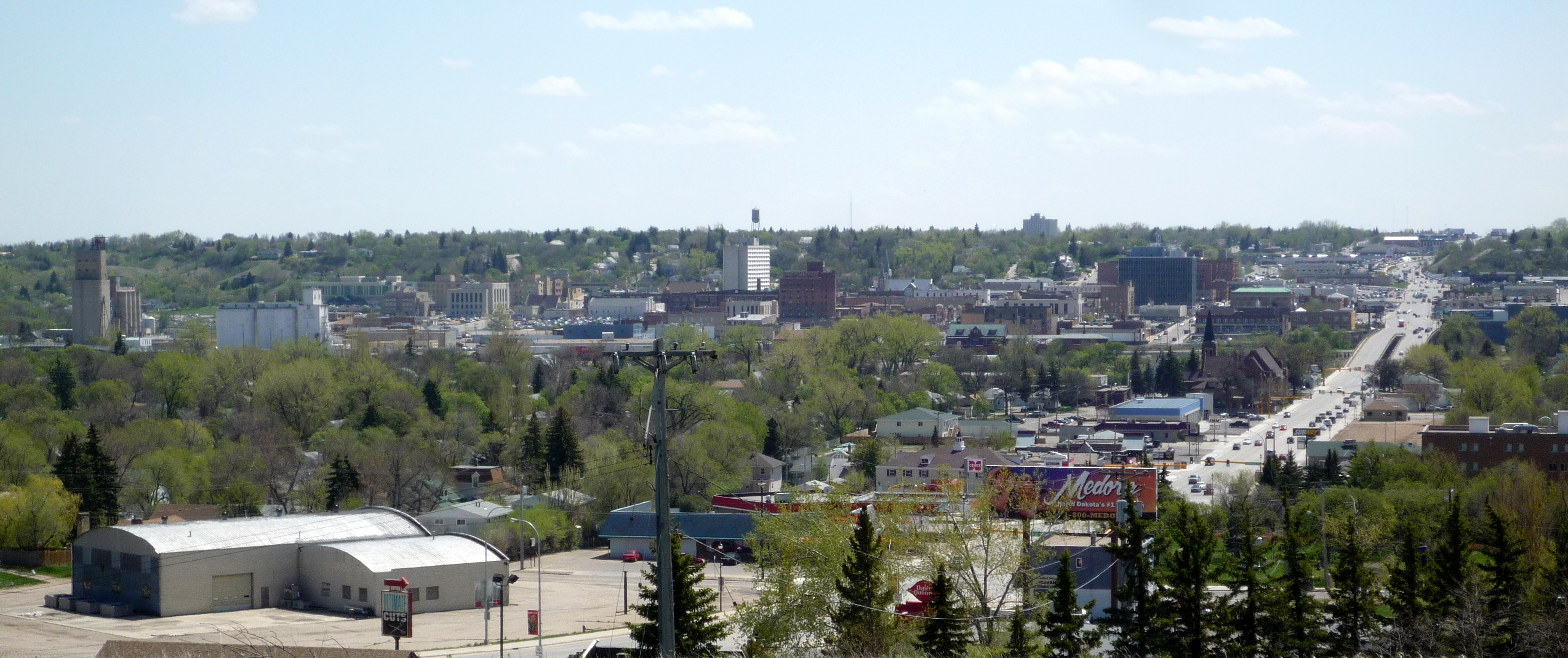
Minot |
|
| Coordinates: Coordinates: | |
| Country | United States |
| State | North Dakota |
| County | Ward |
| Founded | 1886 |
| Incorporated | June 28, 1887 |
| Government | |
| • Mayor | Curt Zimbelman |
| Area[1] | |
| • City | 17.45 sq mi (45.20 km2) |
| • Land | 17.43 sq mi (45.14 km2) |
| • Water | 0.02 sq mi (0.05 km2) |
| Elevation | 1,621 ft (494 m) |
| Population (2010)[2] | |
| • City | 40,888 |
| • Estimate (2011[3]) | 42,485 |
| • Density | 2,345.8/sq mi (905.7/km2) |
| • Metro | 72,067 (118th) |
| Time zone | CST (UTC-6) |
| • Summer (DST) | CDT (UTC-5) |
| Zip code | 58701-58705, 58707 |
| Area code(s) | 701 |
| FIPS code | 38-53380 |
| GNIS feature ID | 1030249[4] |
| Highways | US 2, US 2 Bus., US 52, US 52 Bus., US 83, US 83 Byp. |
| Website | minotnd.org |
Minot ( /ˈmaɪnɒt/ MY-not) is a city located in north central North Dakota in the United States. It is most widely known for the Air Force base located approximately 15 miles north of the city. With a population of 40,888 at the 2010 census,[5] Minot is the fourth largest city in the state. A housing study completed by the Minot Area Development Corporation in 2011 estimated that 45,508 people live within the city limits.[6] The city is the county seat of Ward County[7] and is a trading center for a large portion of northern North Dakota, southwestern Manitoba, and southeastern Saskatchewan. Founded in 1886 during the construction of the Great Northern Railway, Minot is also known as "Magic City", commemorating its remarkable growth in size over a short time.
Minot is the principal city of the Minot Micropolitan Statistical Area, a micropolitan area that covers McHenry, Renville, and Ward counties[8] and had a combined population of 69,540 at the 2010 census.
History[]


Dakota Territory circa 1886, showing Burlington and Minot.
Minot came into existence in 1886, when James J. Hill's Great Northern Railway ended its push through the state for the winter, after having difficulty constructing a trestle across Gassman Coulee. It was the end of the railway's line, so whenever a train came into the town and the stop was announced, the conductor would call out "Minot, this is Minot, North Dakota, prepare to meet your doom". A tent town sprung up overnight, as if by "magic", thus the city came to be known as the Magic City, and in the next five months, the population increased to over 5,000 residents, further adding to the nickname's validity.
The town site was chosen by the railroad to be placed on the land of then-homesteader Erik Ramstad. Ramstad was convinced to relinquish his claim, and became one of the city leaders.
The town was named after Henry D. Minot, a railroad investor, an ornithologist and friend of Hill. Its Arikara name is niwaharít sahaáhkat [niWAharít sAhaáhkAt, niWAharít shaáhkAt]; [9] its Hidatsa name is dibiarugareesh, ("Plum Coulee").[10]
The city was incorporated on June 28, 1887.
The Minneapolis, St. Paul and Sault Ste. Marie Railroad (Soo Line) later built a line from Valley City up to Canada. While initially their plan was to cross the Souris River at Burlington, local interests and arguments convinced them otherwise; landholders along the new route donated the right-of-way. They reached Minot in 1893.
Minot and its surrounding area were wide open throughout 1905-20. Population grew rapidly due to railroad construction and availability of unclaimed land. Nearly complete court records of Ward County and Minot document the prevalence and different types of criminal activity, and offer strong support for the dubious title of "crime capitol of North Dakota." State attorney general William Langer helped clean up the town in 1917-1920, but when Prohibition arrived in the 1920s the city was nicknamed "Little Chicago", as it was a supply hub of Al Capone's liquor smuggling operations. Smugglers used a network of underground tunnels (some of which were previously built for heating or deliveries) to transport and conceal the illicit cargo entering from Canada.[11]
The 1950s saw a large influx of federal funding into the region, with the construction of Minot Air Force Base (1956–57) thirteen miles (20 km) north of the city, and Garrison Dam (1947–53) on the Missouri River, about fifty miles (80 km) south of Minot.


The Old Soo Depot Transportation Museum is housed in the historic Soo Line depot (built 1912) in downtown Minot.
In 1969, a severe flood on the Souris River devastated the city. Afterward, the Army Corps of Engineers straightened the path of the river through the city and built several flood control structures.
On January 18, 2002, a severe train derailment west of the city sent a gigantic cloud of anhydrous ammonia toward Minot, and Burlington. One man died and many of Minot's citizens were sickened and severely injured by the noxious gas, causing one of the worst major chemical accidents of the country.[12] In early 2006, court cases were heard in Minneapolis, Minnesota, against Canadian Pacific Railway, the owner of the derailed train. Several cases have been settled and many others are pending. The anhydrous ammonia spill was the largest such spill in U.S. history. This incident was addressed by Eric Klinenberg in his book Fighting for Air: The Battle to Control America's Media as an example of the failure of mass-Media, specifically local radio stations, to disseminate information to the public in an emergency situation.[13]
The 2011 Mouse (Souris) River flood caused extensive damage throughout the Mouse River Valley. On June 21, 2011, KXMC TV reported that a flood of historic proportions was imminent in the Mouse (Souris) River Valley, largely due to large dam releases upstream. Around 12,000 people were evacuated. On June 26, flooding exceeded previous records when the river crested at 1,561.72 feet above sea level, three feet above the previous record set back in 1881. It is estimated that 20 percent of Minot sustained damage from the flood. This figure includes over 4,100 homes which were someway affected, 2,376 extensively damaged, and 805 damaged beyond repair. The nearby town of Burlington was also severely damaged during this time.[14][15]
Geography[]
According to the United States Census Bureau, the city has a total area of 17.45 square miles (45.20 km2), of which, 17.43 square miles (45.14 km2) is land and 0.02 square miles (0.05 km2) is water.[1]
Neighborhoods[]
Minot is commonly divided into three major divisions. These divisions are North Hill, the Souris River Valley and South Hill. North Hill is the area roughly north of Eleventh Avenue North and Northwest Avenue. South Hill is a broad area south and west of Valley Street and Fifth Avenue South. West of Sixth Street West, South Hill dips sharply to the southwest. The limits of South Hill are less clearly defined than North Hill. Though the neighborhood levels out past Sixteenth Street South, the name South Hill is generally applied to all areas south up to the city limits. Neighborhoods in the Souris River Valley include Bel Air, Downtown, Eastwood Park, Oak Park and West Minot.
Region[]
Minot is located on the Drift Prairie of northwestern North Dakota. Minot is at [16], about 100 miles (160 km) north of Bismarck. The Souris River, or Mouse River, runs through the city west to east.
Important cities in the region for which Minot is the trading center include Burlington, Velva, Garrison, Stanley, Bottineau, Rugby, and New Town.
Minot is almost entirely land; the Souris River, its oxbow lakes, and a few creeks take up just 0.14% of the city's total area.
The elevation of the river at the city center is 1,540 feet (469 m) above sea level.[17] The valley sits some 160 feet (50 m) below the surrounding plains; the elevation at the Minot International Airport on "North Hill" is 1,716 feet (523 m). The city has several small horshoe-shaped oxbow lakes in its limits near the river, created due to the Souris's meandering course.
Grid and address system[]
The city is laid out on a grid-based street system. Streets run north-south and avenues run east-west. Streets are numbered by their block distance east or west of Main Street. Similarly, Avenues are numbered north and south of Central Avenue. There are four city quadrants (NW, SW, SE, NE) to describe the exact location of any given address. Main Street addresses are simply designated North and South. Central Avenue addresses are simply designated East and West. The grid addressing system carries over into the rural areas of Ward County, making the county one of only two that do not follow the statewide grid system in North Dakota (the other being Grand Forks County).
Souris River[]
The Souris River divides the city approximately in half, north and south. The valley rises to the plains both north and south of the river. Although there are names for certain features of these hills, such as Anthony Hill on South Hill, there are no general names for these topographical features. The northern rise and the plateau north of it are referred to as North Hill and the southern rise and plateau south of it are referred to as South Hill.[18]
Climate[]
Minot experiences a cool-summer Humid continental climate (Köppen climate classification Dfb), with four distinct seasons and moderate annual precipitation. Summers range from warm to moderately hot, with frequent thunderstorm activity. Winters are typically bitterly cold and snowy, with high winds and below-freezing temperatures for weeks at a time. Temperatures below 0 °F (-18 °C) are common in the winter, while temperatures can reach above 100 °F (38 °C) in the summer.[19] The average annual snowfall total for Minot is 46.1 inches.
| Climate data for Minot, ND | |||||||||||||
|---|---|---|---|---|---|---|---|---|---|---|---|---|---|
| Month | Jan | Feb | Mar | Apr | May | Jun | Jul | Aug | Sep | Oct | Nov | Dec | Year |
| Record high °F (°C) | 56 (13) |
66 (19) |
79 (26) |
94 (34) |
99 (37) |
102 (39) |
105 (41) |
107 (42) |
106 (41) |
94 (34) |
75 (24) |
58 (14) |
107 (42) |
| Average high °F (°C) | 21 (−6) |
26 (−3) |
37 (3) |
55 (13) |
67 (19) |
75 (24) |
82 (28) |
81 (27) |
70 (21) |
55 (13) |
37 (3) |
24 (−4) |
52.5 (11.4) |
| Average low °F (°C) | 3 (−16) |
9 (−13) |
19 (−7) |
32 (0) |
43 (6) |
53 (12) |
58 (14) |
56 (13) |
46 (8) |
34 (1) |
20 (−7) |
7 (−14) |
31.6 (−0.2) |
| Record low °F (°C) | −34 (−37) |
−34 (−37) |
−29 (−34) |
−5 (−21) |
17 (−8) |
32 (0) |
39 (4) |
32 (0) |
21 (−6) |
−2 (−19) |
−20 (−29) |
−36 (−38) |
−36 (−38) |
| Precipitation inches (mm) | 0.51 (13) |
0.42 (10.7) |
0.84 (21.3) |
1.14 (29) |
2.50 (63.5) |
3.58 (90.9) |
2.43 (61.7) |
2.04 (51.8) |
1.46 (37.1) |
1.16 (29.5) |
0.75 (19.1) |
0.38 (9.7) |
17.21 (437.1) |
| Source: The Weather Channel[20] | |||||||||||||
Demographics[]
| Historical populations | |||
|---|---|---|---|
| Census | Pop. | %± | |
| 1890 | 575 | ||
| 1900 | 1,277 | 122.1% | |
| 1910 | 6,188 | 384.6% | |
| 1920 | 10,476 | 69.3% | |
| 1930 | 16,099 | 53.7% | |
| 1940 | 16,577 | 3.0% | |
| 1950 | 22,032 | 32.9% | |
| 1960 | 30,604 | 38.9% | |
| 1970 | 32,290 | 5.5% | |
| 1980 | 32,843 | 1.7% | |
| 1990 | 34,544 | 5.2% | |
| 2000 | 36,567 | 5.9% | |
| 2010 | 40,888 | 11.8% | |
| Est. 2011 | 42,485 | 16.2% | |
2011 estimate[21] | |||
2010 census[]
As of the census[2] of 2010, there were 40,888 people, 17,863 households, and 9,978 families residing in the city. The population density was 2,345.8 inhabitants per square mile (905.7 /km2). There were 18,744 housing units at an average density of 1,075.4 per square mile (415.2 /km2). The racial makeup of the city was 90.2% White, 2.3% African American, 3.2% Native American, 0.9% Asian, 0.1% Pacific Islander, 0.6% from other races, and 2.7% from two or more races. Hispanic or Latino of any race were 2.7% of the population.
There were 17,863 households out of which 26.3% had children under the age of 18 living with them, 42.1% were married couples living together, 9.6% had a female householder with no husband present, 4.1% had a male householder with no wife present, and 44.1% were non-families. 34.9% of all households were made up of individuals and 11.7% had someone living alone who was 65 years of age or older. The average household size was 2.20 and the average family size was 2.86.
The median age in the city was 33.8 years. 21.1% of residents were under the age of 18; 14% were between the ages of 18 and 24; 26.7% were from 25 to 44; 23.2% were from 45 to 64; and 15% were 65 years of age or older. The gender makeup of the city was 49.3% male and 50.7% female.
2000 census[]
As of the census[22] of 2000, there were 36,567 people, 15,520 households, and 9,265 families residing in the city. The population density was 2,513.1 per square mile (970.4/km²). There were 16,475 housing units at an average density of 1,132.3 per square mile (437.2/km²). The racial makeup of the city was 93.18% White, 1.34% African American, 2.76% Native American, 0.62% Asian, 0.07% Pacific Islander, 0.49% from other races, and 1.54% from two or more races. Hispanic or Latino of any race were 1.47% of the population.
The most populous ancestry groups in the city are German (40.8%), Norwegian (32.3%), Irish (8.7%), English (5.4%), Swedish (4.2%) and French (3.2%).
There were 15,520 households, of which 28.6% had children under the age of 18 living with them, 46.6% were married couples living together, 10.0% had a female householder with no husband present, and 40.3% were non-families. 32.5% of all households were made up of individuals and 12.0% had someone living alone who was 65 years of age or older. The average household size was 2.27 and the average family size was 2.90.
In the city the population was spread out with 23.2% under the age of 18, 13.3% from 18 to 24, 27.4% from 25 to 44, 20.7% from 45 to 64, and 15.4% who were 65 years of age or older. The median age was 35 years. For every 100 females there were 93.1 males. For every 100 females age 18 and over, there were 89.0 males.
As of 2000 the median income for a household was $32,218, and the median income for a family was $42,804. Males had a median income of $30,283 versus $20,023 for females. The per capita income for the city was $18,011. About 8.8% of families and 12.8% of the population were below the poverty line, including 16.0% of those under age 18 and 8.9% of those age 65 or over.
Law and government[]
The mayor of Minot is Curt Zimbelman, a banker. As mayor he chairs the 14-member City Council, but only casts a vote to break a tie. The day-to-day affairs of the city are handled by the City Manager, currently David Waind.
Minot uses the Council-manager system of government. Fourteen councilmen are elected from 7 city wards to four-year terms. Elections are arranged such that one councilman from each ward is elected in every even-numbered year. The mayor of Minot is elected to a four-year term as well; the last mayoral election was in 2006. All city offices are nonpartisan.
City elections are held in June in North Dakota, along with the state primary election.
While the city's leadership has been trending towards the conservative, Minot's liberal factions have been active in recent years and have had somewhat more success than in other areas of the state.
Policy[]
Minot's civic realm includes a number of debates over taxes, fiscal management, and economic development policy.
Major issues include:
Economic development[]
In recent years, economic development has become a significant issue in the city of Minot. The city created the publicly financed MAGIC Fund in 1992 to provide financial incentives for businesses, but a series of debacles made the operations of the fund a significant issue in the 2002 city elections.
Northwest Area Water Supply (NAWS)[]
The Northwest Area Water Supply is slightly less controversial among residents of Minot and area, however, it has attracted the ire of the Canadian government because the plan calls for water to be pumped from Lake Sakakawea, then to Minot for treatment, and then on to large stretches of Northwest North Dakota.
Minot voters decided in 1998 to levy a 1% sales tax to go towards the construction of NAWS; this tax fund was found in court to have been illegally diverted towards economic development purposes. A lawsuit was filed against the city and it was ordered to return the misappropriated funds to the NAWS fund. By that time, the money had already been spent, and the city instead voted to issue a special assessment on city water bills to raise the funds.
Economy[]
Minot's economy depends on the Air Force Base located 13 miles (21 km) north of town making the city's economy more robust than other cities of its size due to its large service area; however, it is beset by significant problems with enterprise capital and wage standards. About 30% of Minot residents work two or more jobs, and two-thirds of households earn less than the national median household income.
ING/ReliaStar established a service center in Minot in December 1998.
"ING chose Minot for our expansion because our service center employees have demonstrated that they can provide unsurpassed customer service. I think this decision speaks volumes about Minot and the caliber of people who live and work here," Tom McInerney, CEO, ING U.S. Financial Services.[23]
Minot has seen a huge increase in population and infrastructure investments in the last several years with the expanding drilling (using the 'frac' petroleum extraction technique) of oil in the Bakken Formation and Three Forks Groups.[24] The State of North Dakota has a website detailing daily oil activity.
Education[]
The Minot Public Schools system operates ten elementary schools (K-5) within the city: Bel Air, Edison, Lewis and Clark, Lincoln, Longfellow, McKinley, Roosevelt, Perkett, Sunnyside, and Washington. Jefferson Elementary was closed in 2003. The old Washington Elementary building was closed at the end of 2007 and the students moved to a new building which was renovated from an old health care center. There are also two elementary schools (K-6) on the Minot Air Force Base: Dakota and North Plains.
There are three middle schools in the system: the two in Minot are grades 6-8: Jim Hill in the south and Erik Ramstad in the north. Memorial Middle School (grades 7-8) on Minot AFB, is named for fallen veterans of the U.S. armed forces. The school was built in the mid-1960s on the northern perimeter of the base. All three middle schools were formerly called "junior high" schools.
The city has one public high school, Minot High School, divided between two campuses. A few blocks east of Downtown Minot is Central Campus (grades 9-10), which occupies the original high school building. On the southwest side of the city is the newer Magic City Campus (grades 11-12), constructed in 1973 just west of Jim Hill Middle School. MPS also operates an adult learning center and Souris River Campus, an alternative high school. [4]
Private schools in Minot include the Minot Catholic Schools system which operates an elementary school, Little Flower, and Bishop Ryan High School, a combined middle school and high school (grades 6-12). There is also a Protestant K-12 school, Our Redeemer's Christian School [5].
Minot is also home to Minot State University, the third largest university in the state. MSU's campus is at the base of North Hill, just west of Broadway. Originally a two-year teacher's college when opened in 1913, Minot State became a university in 1987.
Preschool and daycare[]
Most of the larger daycare centers and pre-schools in the Minot area work in collaboration with local church groups. There are also programs such as Head Start and preschool programs through Minot Public Schools. The in-home daycare providers are state registered/licensed.
Culture[]
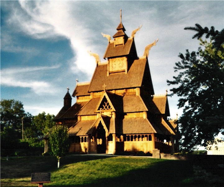

The "stave church" in Minot's Scandinavian Heritage Park


The "Dala horse" in the Scandinavian Heritage Park
Minot's Midwestern setting and attitudes sometimes hides its sizable and sometimes flamboyant arts community. Minot has an art museum, a symphony orchestra, an opera company, a city band, several dance and theater troupes, a youth/punk concert organization, the AMP, and much more; over 40 organizations claim membership in the Minot Area Council on the Arts, and even more exist.
Nearly 40% of the city's residents are of Scandinavian ancestry, and every October since 1977, Minot has been the host to the Norsk Høstfest, North America's largest Scandinavian-American festival. Scandinavian Heritage Park is located in Minot. Scandinavian Heritage Park features remembrances and replicas from each of the Scandinavian countries: Sweden, Norway, Denmark, as well as Finland and Iceland.
Recreation[]
The Minot Park District operates seventeen parks with various facilities; Corbett Field, home to American Legion, high school and college baseball; Optimist soccer complex; MAYSA ice arena; the Sertoma Complex which has 8 softball fields; Souris Valley Golf Course, and an indoor tennis complex.
The city's largest parks are Roosevelt Park and Oak Park. Roosevelt Park Zoo is one of the top zoos in the region. Dogs are allowed in Roosevelt Park, a sign is posted at the entrance confirming this. A "bark park" for dogs opened in the summer of 2005.
The North Dakota State Fair is held annually in Minot. Nearly all recreation areas however are closed during the long winters. The local high school hockey teams use the ice rink located in the Fair Grounds. The ice rink is also turned into the location of the rodeo.
Apple Grove Grove Golf Course, and Souris Valley Golf Course are located in Minot. The Minot Country Club is located near Burlington.
Sports[]
- The Magic City Snowbears, were an International Basketball Association team that played their games at Minot Municipal Auditorium. This team disbanded after only one season.
- The Minot Mallards, were a Mandak League team that played their games at Corbett Field.
- The Minot Minotauros, an NAHL team, play their games at Maysa Arena.
- The Minot Muskies, played one season with the American West Hockey League and played their games at All Seasons Arena.
- The Minot Skyrockets, a former Continental Basketball Association team, played their games at Minot Municipal Auditorium.
- The Minot State Beavers play ice hockey at All Seasons Arena, baseball at Corbett Field, football at Herb Parker Stadium and basketball at the MSU Dome.
- The Mouse River Rollers play roller derby at different locations around the city, including the Maysa Arena.
- Minot is home of the only Professional Wrestling company in the State, Northern Outlaw Wrestling.
- Minot is home to several municipal sports venues including All Seasons Arena, Corbett Field, Maysa Arena and the Minot Municipal Auditorium.
Sister cities[]
Minot maintains a sister city relationship with the Norwegian city of Skien.
Minot is also a sister city of Moose Jaw, Saskatchewan, about 300 miles (480 km) to the north-west. The cities share many qualities, including their size, location on river valleys, historical origins, and air force bases.
Media[]
Minot has several media outlets. KMOT-TV, KXMC-TV and the Minot Daily News report on local news daily. KCJB-AM, KHRT-AM, and Prairie Public have some local news content, but no active journalists.
- Radio
Minot has fifteen radio stations (12 FM, 3 AM). Bottineau-based Programmer's Broadcasting owns KTZU and KWGO, along with KBTO of Bottineau. North Dakota Public Radio operates KMPR FM 88.9, a local community broadcaster based in Burlington operates a low-power FM station, and the remainder are nonprofit Christian stations, of which only KHRT is based locally.
Clear Channel owns and operates KCJB 910 (Country & Talk), KRRZ 1390 (Oldies/Talk), KYYX 97.1 (Country), KIZZ 93.7 (Top 40), KMXA-FM 99.9 (Hot AC), and KZPR 105.3 (Rock) all in Minot. In May 2007, it was announced that Clear Channel sold the Minot group to Dean Goodman's GoodRadio, LLC. It was confirmed on May 16, 2007, by filings made public with the FCC. Then in the next couple of months, GoodRadio's plans fell through when its financing group, American Securities Capital Partners, objected to the deal's $452 million costs.
- AM Frequencies
- 910 KCJB - "91 Country" Classic country/Talk
- 1320 KHRT - "K-Heart" Gospel Music
- 1390 KRRZ - "Cars" Classic Hits
- FM Frequencies
- 88.9 KMPR - Prairie Public Radio
- 91.1 K220GC - HBN Radio Christian
- 91.9 K216EE - K-Love Christian
- 93.7 KIZZ - "Z94" Top 40/CHR
- 94.9 KTZU - "The Zoo" Classic rock
- 97.1 KYYX - "97 Kicks" Country
- 98.1 KOWW-LP - "The Cowlip" eclectic community broadcaster (Burlington, North Dakota)
- 99.9 KMXA-FM - "Mix 99.9" Adult Contemporary
- 102.9 KWGO - "W-G-O" Adult Contemporary
- 104.1 KSAF-LP - 3ABN Radio Christian
- 105.3 KZPR - "The Fox" Active Rock
- 106.9 KHRT - "K-Heart" Christian
- Other Stations
Additionally, the following stations are not based in Minot, but generally have a clear signal into town:
- 550 AM KFYR - "K-Fire" from Bismarck (News/Talk/Sports)
- 710 AM KXMR - ESPN, also from Bismarck (Sports)
- 1410 AM KDKT - "Fox Sports Radio 1410" also from Bismarck (Sports)
- 101.9 FM KBTO - "Sunny 101.9" from Bottineau (Country)
- Television
Minot has six television stations, most of which have ATSC (digital) transmitters:
- 6 KSRE - PBS, part of Prairie Public Television (ATSC 40)
- 10 KMOT - NBC (ATSC 10)
- 13 KXMC - CBS (ATSC 45)
- 14 KMCY - ABC (ATSC 14)
- 21 K21GQ - The Church Channel
- 24 KXND - Fox
- Cable Service
Midcontinent Communications provides cable service to the city of Minot and Minot Air Force Base. Midcontinent offers a Bismarck-originating The CW cable station, KWMK, on channel 14, as well as KMSU (a cable station operated by the Minot State University broadcasting department) on channel 19. Souris River Telecommunications provides cable service to other nearby communities.
The principal local newspaper is the Minot Daily News (originally the Burlington Reporter), which publishes seven days a week. The Minot State University student newspaper The Red & Green is published once a week (Thursdays) during the regular school year, but not during the summer months. Morgan Printing produces the Lunch Letter three days a week on a double-sided leaflet. There are is one weekly classified-ad publication, the Trading Post, printed by the Minot Daily News'. The Bismarck Tribune is available at several outlets in the city, as is The Forum, to a lesser extent.
Transportation[]
Railroads[]
The railroads that built Minot remain, though Great Northern is now part of the BNSF Railway and the Soo Line is run by the Canadian Pacific Railway.
Passenger rail transportation is provided daily on Amtrak's Empire Builder line which stops at the Minot Amtrak station. This is the only scheduled service stop between Minneapolis, Minnesota, and Havre, Montana. Trains make a 20-minute refueling and crew change stop in Minot; Westbound trains arrive about 9:00 am local time. Eastbound trains arrive about 9:00pm. In June, the Empire Builder suspended service between St. Paul, Minnesota, and Havre, Montana. Although service has since resumed, Minot's train station is still undergoing repairs from the Souris River flood. The baggage area of the train station has been temporarily converted into a waiting lounge to accommodate Amtrak's passengers.[25]
Highways[]
Three U.S. highways run through the city: US-2, US-52, and US-83.
US-2 runs east-west and is a four-lane highway from Minot east to Grand Forks and also four lanes from Minot west to Williston. In February 2004 it was announced that Highway 2 would be expanded to four lanes between Minot and Williston by 2008 and this has been completed.
US-83 runs north-south through central Minot as Broadway. It is a four-lane highway from Minot south to Bismarck and north to Minot Air Force Base. Just north of the main gate at the base, the road reduces to two lanes and crosses the Canadian border at Westhope, ND, where it becomes Manitoba Highway 83.


US-83 running through north Minot
US-52 runs southeast-northwest. Southeast from Minot, it follows a slightly circuitous route to Jamestown, where it meets up with Interstate 94. Highway 52 merges with I-94 after Jamestown, going due east to Fargo. Northwest from Minot, US-52 crosses the Canadian border at Portal, ND/North Portal, SK, where it becomes Saskatchewan Highway 39.
Minot has a bypass for these routes around the south and west sides of the city.
Airport[]
Minot International Airport is served by Delta Air Lines five times daily. Allegiant Air provides two weekly round trips to Las Vegas McCarran International Airport and Phoenix-Mesa Gateway Airport. Las Vegas service takes place on Monday and Friday and Phoenix-Mesa service on Thursday and Sunday. Until the early 1990s, it was also served by Denver-based Frontier Airlines and its successor, Continental Airlines, then, briefly, by the new iteration of Frontier in 1994. Airport officials are constantly looking for additional service, and efforts have proved to be successful as of late. There are five daily flights from Minot to Minneapolis at 5:00am, 6:30am and 10:58am, 1:33 pm, and 4:23 pm. On June 9, 2010, United Airlines carrier SkyWest Airlines began service to the city, with two daily flights each way between Minot and United's Denver hub on 50-seat Bombardier CRJ aircraft. In May 2010, Comair began daily service to Salt Lake City, but the route was cancelled in September due to the small number of people flying the route.
Within the city[]
Automobiles dominate intracity and local area transport. There is limited fixed-route city transit service (Minot City Transit) on weekdays, and flexible-route rural transit service (Souris Basin Transportation) on an occasional basis. Local transit services for the elderly and disabled (Minot Commission on Aging Transit) meet federal guidelines but have 24-hour advance notice requirements.
Pedestrianism in the city is inhibited by several factors; the sidewalk network is poor in many areas of the city, though improving. Automobile drivers take the right of way at all but the best-marked crosswalks, and major points are often separated by relatively large distances and hill slopes. Skateboarding is illegal in streets and on sidewalks (though there is a skating area in Roosevelt Park), and rollerblading is generally disallowed by downtown landowners.
Sites of interest[]


Scandinavian Heritage Park
- 62 Doors Art Gallery, is an art gallery downtown displaying local artwork
- Arlene Theater, a performing arts center, where the Mouse River Players perform
- Dakota Territory Air Museum is an aircraft museum near the airport. It contains many war and civilian aircraft.
- The Scandinavian Heritage Park is home to the Minot Visitor's Center, as well as buildings based on the Scandinavian style of architecture. The grounds are home to the Minot's Arts in the Park series.
- Lucy's Amusement Park, features an 18-hole miniature golf course and various slides and rides.
- Minot Riverwalk, a two and a half mile long trail for walking and biking along the Souris River in Downtown Minot.
- Northwest Art Center, at Minot State, features two galleries of contemporary art.
- Old Soo Depot Transportation Museum, museum and research center in the restored 1912 Soo Line Depot.
- Pangea House is a community center, which hosts Why Not Fest, a music and arts festival.
- Pioneer Village, on the state fairgrounds, is a collection of various buildings from the pioneer era.
- The North Dakota State Fair Center, located on the state fairgrounds, is home to many of the city's largest events, including: The North Dakota State Fair, the Norsk Høstfest, the Big One craft show, the KMOT Ag Expo, and the Great Tomato Festival. It also hosts rodeos, and college hockey games.
- The Railroad Museum of Minot, open on Saturdays, has displays and artifacts related to the rail history of the city and the state.
- Roosevelt Park and Zoo
- Taube Museum of Art, located in the 1906 Union National Bank Building, features exhibit space in the Main Gallery and the Lower Gallery, which change every four to six weeks.
Notable people[]
- Nicole Borud, contestant on America's Next Top Model, Cycle 3
- Ronnie Bradford, defensive back in the NFL
- Dale Brown, basketball coach with LSU
- Gary Cederstrom, umpire with MLB
- Josh Duhamel, Emmy Award-winning actor, married to Fergie of The Black Eyed Peas
- Ron Erhardt, football coach at Bishop Ryan High School and, eventually, the New England Patriots.
- Hans Andersen Foss, Norwegian-born author, newspaper editor and temperance leader
- Brynhild Haugland, 52-year member of the North Dakota House of Representatives
- Randy Hedberg, quarterback in the NFL
- John Hoeven, 31st Governor of North Dakota, later elected Senator; worked as a banker here between college and his political career
- Gary Johnson, 29th Governor of New Mexico and 2012 presidential candidate
- Simon Johnson, Norwegian-born author and newspaper editor
- David C. Jones, U.S. Air Force General, former Chairman of the Joint Chiefs of Staff (1978–82)
- Boris Karloff, actor, star of 1931's Frankenstein, lived in Minot for a year
- Wiz Khalifa, rapper
- Dagny Knutson, USA Professional Swimmer - award winning
- Brian Kane Lee, 1994 Scripps National Spelling Bee runner-up
- Arthur LeSueur, Mayor of Minot, newspaper editor and organizer of the Socialist Party of North Dakota
- Matthew Lowe, USA Professional Swimmer - award winning
- Kevin Miller, voice actor for the Sly Cooper series
- Michael H. Miller, U.S. Navy Rear Admiral, former commander of Carrier Strike Group Seven
- Herro Mustafa, diplomat, senior adviser on the Middle East to Vice President Joe Biden
- Ragnvald A. Nestos, 13th Governor of North Dakota
- Casper Oimoen, ski jumping champion, captain of the U.S. Ski Jumping team (1936)
- Erik Ramstad, city founder
- Greg "Fossilman" Raymer, winner of 2004 World Series of Poker
- Clinton Romesha, Medal of Honor recipient
- Donny Schatz, champion sprint car driver with the World of Outlaws (2006)
- Charles F. Wald, former Deputy Commander of United States European Command
- Christopher Michael Holley, film and television actor
- Tim Jackman, professional ice hockey player
- Michael Soltis, film and television actor and abstract artist
References[]
- ^ a b "US Gazetteer files 2010". United States Census Bureau. http://www.census.gov/geo/www/gazetteer/files/Gaz_places_national.txt. Retrieved 2012-06-14.
- ^ a b "American FactFinder". United States Census Bureau. http://factfinder2.census.gov/faces/nav/jsf/pages/index.xhtml. Retrieved 2012-06-14.
- ^ "Population Estimates". United States Census Bureau. http://www.census.gov/popest/data/cities/totals/2011/files/SUB-EST2011-IP.csv. Retrieved 2013-01-04.
- ^ "US Board on Geographic Names". United States Geological Survey. 2007-10-25. http://geonames.usgs.gov. Retrieved 2008-01-31.
- ^ "2010 Census Redistricting Data (Public Law 94-171) Summary File". American FactFinder. United States Census Bureau. http://factfinder2.census.gov/faces/tableservices/jsf/pages/productview.xhtml?pid=DEC_10_PL_GCTPL2.ST13&prodType=table. Retrieved 2 May 2011.
- ^ Minot Housing Study Minot Area Development Corporation. Retrieved 2011-07-07
- ^ "Find a County". National Association of Counties. http://www.naco.org/Counties/Pages/FindACounty.aspx. Retrieved 2011-06-07.
- ^ Micropolitan statistical areas and components, Office of Management and Budget, 2007-05-11. Accessed 2008-07-27.
- ^ "AISRI Dictionary Database Search-- Arikara. Prototype version". http://zia.aisri.indiana.edu/~dictsearch/cgi-bin/testengltoxsrchNP.pl?host=zia&pass=&hasfont=0&srchlang=English&srchstring=dakota&database=arika&srchtype=OR&sortlang=Indian&sndformat=mp3&maxhits=200&find=Run_Search. Retrieved 2012-07-08.
- ^ "Hidatsa Lessons Vocab2". Hidatsa Language Program. http://www.neiu.edu/~linguist/hidatsa_lessons_vocab2.html#villages_dwellings_and_towns_i. Retrieved 2012-07-17.
- ^ Michael J. Martin and Glenn H. Smith, "Vice and Violence in Ward County, North Dakota, 1905-1920," North Dakota History, 1980, Vol. 47 Issue 2, pp 10-21
- ^ CBC News, Minot train derailment kills one, injures dozens
- ^ Klinenberg, Eric. Fighting for Air: The Battle to Control America's Media. Holt: New York, 2008.
- ^ Fundingsland, Kim (June 21, 2011). "‘It’s a sad day’ — Crest could be 10 feet higher than June 1". Minot Daily News. http://www.minotdailynews.com/page/content.detail/id/555952/-It-s-a-sad-day----Crest-could-be-10-feet-higher-than-June-1.html. Retrieved April 6, 2012.
- ^ The Minot Convention and Visitor's Bureau. http://visitminot.org/smartmail/newsletterview.asp?NLID=75&UID=156. Retrieved 9/11/2011
- ^ "US Gazetteer files: 2010, 2000, and 1990". United States Census Bureau. 2011-02-12. http://www.census.gov/geo/www/gazetteer/gazette.html. Retrieved 2011-04-23.
- ^ National Weather Service, Advanced Hydrologic Prediction Service, [1]
- ^ Castro, Jenny. "City Budget Adding Jobs". KFYR [2]
- ^ National Climatic Data Center, Monthly Station Normals (1971–2000) for North Dakota, [3]. Retrieved 20 November 2006.
- ^ "Monthly Averages for Minot, ND". The Weather Channel. 2012. http://www.weather.com/weather/wxclimatology/monthly/graph/USND0242. Retrieved 2012-09-20.
- ^ Moffatt, Riley. Population History of Western U.S. Cities & Towns, 1850-1990. Lanham: Scarecrow, 1996, 179.
- ^ "American FactFinder". United States Census Bureau. http://factfinder.census.gov. Retrieved 2008-01-31.
- ^ "Minot Area Development Corporation". http://minotusa.com/. Retrieved April 7, 2012.
- ^ Oakes, Larry (October 24, 2011). "North Dakota: where the jobs are". The Seattle Times. http://seattletimes.nwsource.com/html/nationworld/2016599974_dakotaoil25.html.
- ^ Ogden, Eloise (November 15, 2011). "Amtrak resumes Minot service". Minot Daily News. http://www.minotdailynews.com/page/content.detail/id/560394.html. Retrieved April 6, 2012.
External links[]
- City of Minot
- Convention and Visitors Bureau
- Chamber of Commerce
- Minot International Airport
- Minot Amtrak
- Minot Daily News
- Minot Public Schools
History[]
- Exploring Minot History 1885-1900
- Minot History 1900-1920 by Gaylen Brown
- History of Minot from 1920-1940
- Minot history (MSU)
- Collected stories of January 18, 2002, CP Rail derailment and anhydrous ammonia spill
Other[]
 Minot travel guide from Wikivoyage
- RallyMinot - website for 2011 flood/disaster info
| ||||||||||||||||||||

| |||||||||||||||||||||||
| This page uses content from the English language Wikipedia. The original content was at Minot, North Dakota. The list of authors can be seen in the page history. As with this Familypedia wiki, the content of Wikipedia is available under the Creative Commons License. |