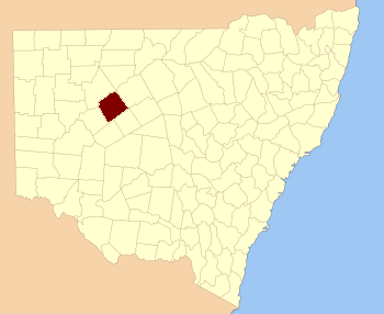
Rankin County is one of the 141 Cadastral divisions of New South Wales . It includes part of the Paroo-Darling National Park. The border to the north-west is the Darling River .
Rankin County was named after Rankin Range – Mount Rankin which is in Bathurst, New South Wales .[1]
Parishes within this county [ ] A full list of parishes found within this county; their current LGA and mapping coordinates to the approximate centre of each location is as follows:
Parish
LGA
Coordinates
Albert Cobar Shire 31°02′03″S 144°44′21″E / -31.03417 , 144.73917 (Albert )
Basin Bank Cobar Shire 31°23′39″S 144°18′01″E / -31.39417 , 144.30028 (Basin Bank )
Bilbo Cobar Shire 31°19′24″S 144°38′12″E / -31.32333 , 144.63667 (Bilbo )
Booborowie Cobar Shire 31°13′01″S 144°19′55″E / -31.21694 , 144.33194 (Booborowie )
Buckinbe Cobar Shire 30°59′39″S 144°30′07″E / -30.99417 , 144.50194 (Buckinbe )
Budda Cobar Shire 31°07′15″S 144°16′48″E / -31.12083 , 144.28 (Budda )
Bulla Bulla Cobar Shire 31°34′56″S 144°46′17″E / -31.58222 , 144.77139 (Bulla Bulla )
Clarke Cobar Shire 31°28′54″S 144°40′00″E / -31.48167 , 144.6666667 (Clarke )
Coombes Cobar Shire 31°24′10″S 144°44′00″E / -31.40278 , 144.7333333 (Coombes )
Darling Cobar Shire 31°20′46″S 144°10′34″E / -31.34611 , 144.17611 (Darling )
Deniehy Cobar Shire 31°29′22″S 144°54′28″E / -31.48944 , 144.90778 (Deniehy )
Donald Plain Cobar Shire 31°34′47″S 144°31′49″E / -31.57972 , 144.53028 (Donald Plain )
Donalroe Cobar Shire 31°11′32″S 144°10′24″E / -31.19222 , 144.17333 (Donalroe )
Etty Cobar Shire 31°23′10″S 144°58′31″E / -31.38611 , 144.97528 (Etty )
Gidgiegalumba Cobar Shire 31°02′20″S 144°50′58″E / -31.03889 , 144.84944 (Gidgiegalumba )
Greenough
Cobar Shire unknown
Keilor Cobar Shire 31°27′59″S 144°15′10″E / -31.46639 , 144.25278 (Keilor )
Kendall Cobar Shire 31°24′00″S 144°29′33″E / -31.4 , 144.4925 (Kendall )
Kirkingle Cobar Shire 31°12′46″S 144°32′56″E / -31.21278 , 144.54889 (Kirkingle )
Lawrence Cobar Shire 31°19′25″S 144°50′11″E / -31.32361 , 144.83639 (Lawrence )
Mary Cobar Shire 31°07′11″S 144°27′47″E / -31.11972 , 144.46306 (Mary )
Millpillbury Cobar Shire 31°19′54″S 144°23′39″E / -31.33167 , 144.39417 (Millpillbury )
Mulga Cobar Shire 31°30′51″S 144°22′54″E / -31.51417 , 144.38167 (Mulga )
Munbunya Cobar Shire 31°08′57″S 144°41′24″E / -31.14917 , 144.69 (Munbunya )
Salisbury
Central Darling Shire unknown
Stanley Cobar Shire 31°38′24″S 144°37′04″E / -31.64 , 144.61778 (Stanley )
Stanley Cobar Shire 31°39′34″S 144°36′26″E / -31.65944 , 144.60722 (Stanley )
Tankarook Cobar Shire 31°02′14″S 144°25′37″E / -31.03722 , 144.42694 (Tankarook )
Thourumble Cobar Shire 31°09′25″S 144°54′11″E / -31.15694 , 144.90306 (Thourumble )
Turner Cobar Shire 31°19′36″S 145°05′39″E / -31.32667 , 145.09417 (Turner )
Wallandra Cobar Shire 30°55′11″S 144°33′51″E / -30.91972 , 144.56417 (Wallandra )
Weelong Bourke Shire 30°54′54″S 144°43′48″E / -30.915 , 144.73 (Weelong )
Weelongbar Cobar Shire 30°58′40″S 144°44′43″E / -30.97778 , 144.74528 (Weelongbar )
Wigilla Cobar Shire 31°13′03″S 144°44′01″E / -31.2175 , 144.73361 (Wigilla )
Woore Cobar Shire 31°43′54″S 144°32′19″E / -31.73167 , 144.53861 (Woore )
Woore Cobar Shire 31°46′36″S 144°29′56″E / -31.77667 , 144.49889 (Woore )
References [ ]