| ||||||||||||||
| Saint Bernard Parish, Louisiana | |||
| |||
 Location in the state of Louisiana | |||
 Louisiana's location in the U.S. | |||
| Founded | 1807 | ||
|---|---|---|---|
| Named for | Patron Saint of Bernardo de Galvez | ||
| Seat | Chalmette | ||
| Largest city | Chalmette | ||
| Area - Total - Land - Water |
1,794 sq mi (4,646 km²) 465 sq mi (1,204 km²) 1,329 sq mi (3,441 km²), | ||
| Population - (2010) - Density |
35,897 56/sq mi (22/km²) | ||
| Time zone | Central: UTC-6/-5 | ||
| Website | www.sbpg.net | ||


St. Bernard Parish (French: Paroisse de Saint-Bernard) is a parish located southeast of New Orleans in the U.S. state of Louisiana. The parish seat is Chalmette, the largest city in the parish. As of 2000, its population was 67,229. It has been ranked the fastest-growing county (parish) in the United States from 2007 to 2008 by the U.S. Census Bureau, but it is only half as populated as it was in 2005. In 2009, because of evacuation and outmigration due to destruction by Hurricane Katrina, its population was estimated to be 33,439[1]
St. Bernard Parish is part of the New Orleans–Metairie–Kenner Metropolitan Statistical Area as well as the New Orleans–Metairie–Bogalusa Combined Statistical Area.
History


Kenilworth Plantation House (originally Bienvenu) in St. Bernard's Terre aux Boeufs dates back to the 1750s.
St. Bernard Parish contains a small community of Spanish descent. Sometimes referred to informally as "Spanish Cajuns", the Isleños are descended from Canary Islanders who arrived around 1780. This linguistically isolated group eventually developed its own dialect. This settlement was first called La Concepcion and Nueva Galvez by Spanish officials, but was later renamed Terre aux Boeufs (French) and Tierra de Bueyes (Spanish) for "land of cattle", because nearby areas were used for cattle grazing. By the end of the 1780s, St. Bernard, the patron saint of Bernardo de Galvez, was used in documents to identify the area.[2]
The chief historical attraction in St. Bernard Parish is the Chalmette National Historical Park (or Chalmette Battlefield), at which the Battle of New Orleans took place on January 8, 1815 during the War of 1812. Many street names near the battlefield bear the names of the chief participants, or take a pirate theme, since the pirate Jean Lafitte was considered to be a hero in the battle. A high school, later elementary and now a middle school, was named in honor of (then Colonel) Andrew Jackson, who was the American commanding officer in the battle.
From 1919 to 1969, the parish was effectively ruled as part of the fiefdom of Leander Perez, a local Democratic official in neighboring Plaquemines Parish.
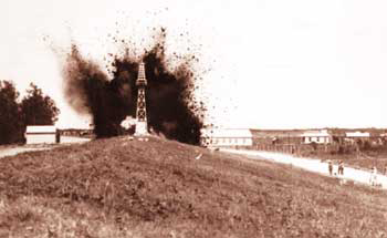
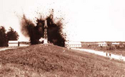
An Army Corps Photo of the levee at Caernarvon being dynamited during the floods of 1927.
During the Great Mississippi Flood of 1927, New Orleans city and state leaders used dynamite to breach a levee at Caernarvon, thirteen miles (19 km) below Canal Street, to save the city of New Orleans from flooding. At the time, it was thought by New Orleans residents that the dynamiting saved the city, but historians now believe that the dynamiting was unnecessary due to major upstream levee breaks that relieved pressure on the New Orleans levees. The levee breach caused flooding and widespread destruction in most of Eastern St. Bernard Parish and parts of Plaquemines Parish. Residents were never adequately compensated for their losses.[3]
Hurricane Katrina and its aftermath
On August 29, 2005, St. Bernard was devastated by Hurricane Katrina. The storm damaged virtually every structure in the parish. The eye of Katrina passed over the eastern portion of the parish, pushing a 25-foot (7.6 m) storm surge into the Mississippi River Gulf Outlet ("MRGO"). This surge destroyed the parish levees. Almost the entire parish was flooded, with most areas left with between 5 and 12 feet (3.7 m) of standing water. The water rose suddenly and violently, during a period which witnesses reported as no more than fifteen minutes. In many areas, houses were smashed or washed off their foundations by a storm surge higher than the roofs.
For more than two months after the storm, much of the parish remained without proper services, including electricity, water, and sewage. Parish President Henry "Junior" Rodriguez, declared all of the parish's homes unlivable. Emergency Communities offered one reason for hope in the first year after Hurricane Katrina. In the parking lot of a destroyed off-track betting parlor, EC built the Made with Love Cafe and Grill, a free kitchen and community center serving 1500 meals per day. Made with Love, housed in a geodesic dome, also offered food and clothing distribution, and emotionally supportive volunteers. Upon leaving, EC has offered logistical support for the founding of a new long-term Community Center of St Bernard[1]
As of late November 2005, it was estimated that the Parish had some 7,000 full-time residents, with some 20,000 commuting to spend the day working, cleaning up, or salvaging in the parish and spending their nights elsewhere. By mid-December some businesses had returned to the Parish, most notably the ExxonMobil plant in Chalmette and the Domino Sugar plant in Arabi, together with a handful of small local stores and businesses.
At the start of January 2006, it was estimated that some 8,000 people were living in the Parish. The H.O.P.E. Project, a collective of volunteer relief workers, founded itself in January 2006 in the empty shell of the Corinne Missionary Baptist Church in Violet, LA, providing the tools for rebuilding and community empowerment. Since June 2006, Camp Hope has been housing volunteers' assisting residents of St. Bernard Parish in their recovery from Hurricane Katrina. It is located at 1914 Aycock Street, Arabi, LA, 70032. A grassroots organization, the St. Bernard Project[2], opened its doors in March 2006. A fully volunteer-run organization funded by the United Way, they help residents get back into their homes by working on the houses, providing tools, support and where possible, funding.
As of October 2006, the population was estimated to be 25,489[4] After population losses due to Hurricane Katrina, the school was reopened for elementary grades for the 2006-2007 school year.
Geography
The parish has a total area of 1,794 square miles (4,646 km²). 465 square miles (1,204 km²) of it is land and, at 1,329 square miles (3,441 km²) water. At 74.07% water, St. Bernard has the largest percentage of area in water of any parish in Louisiana.
The parish of St. Bernard comprises an area of 680 square miles (1,800 km2) and embraces numerous small islands. The parish is classed among the alluvial lands of the state. The ridges comprise the arable lands of the parish and have an area of 37,000 acres (150 km²). The principal streams are the Bayous Terre aux Boeufs and La Loutre. There are numerous smaller streams which are efficient drainage canals. The dominant tree species is bald cypress, of which the most valuable trees have been cut and processed.
Major highways
 Louisiana Highway 39
- Louisiana Highway 46
- Louisiana Highway 47
Adjacent parishes and features
- Lake Borgne (north)
- Mississippi River (south & west)
- Gulf of Mexico (east)
- Hancock County, Mississippi (water border)
- Harrison County, Mississippi (water border)
- Plaquemines Parish (south)
- Orleans Parish (west & northwest)

|
Orleans Parish | Lake Borgne |
| |
| Orleans Parish | Gulf of Mexico | |||
 St. Bernard Parish, Louisiana | ||||
| Plaquemines Parish |
National protected areas
- Breton National Wildlife Refuge (part)
- Jean Lafitte National Historical Park (part, in Chalmette)
Demographics
| Historical populations | |||
|---|---|---|---|
| Census | Pop. | %± | |
| 1900 | 5,031 | ||
| 1910 | 5,277 | 4.9% | |
| 1920 | 4,968 | −5.9% | |
| 1930 | 6,512 | 31.1% | |
| 1940 | 7,280 | 11.8% | |
| 1950 | 11,087 | 52.3% | |
| 1960 | 32,186 | 190.3% | |
| 1970 | 51,185 | 59.0% | |
| 1980 | 64,097 | 25.2% | |
| 1990 | 66,631 | 4.0% | |
| 2000 | 67,229 | 0.9% | |
| 2010 | 35,897 | −46.6% | |
| St. Bernard Parish Census Data[5] | |||
As of the census[6] of 2000, there were 67,229 people (an increase of 598 or 0.9% over the previous decade), 25,123 households, and 18,289 families residing in the parish. The population density was 145 people per square mile (56/km²). There were 26,790 housing units at an average density of 58 per square mile (22/km²). The racial makeup of the parish was 88.29% White, 7.62% Black or African American, 0.49% Native American, 1.32% Asian, 0.02% Pacific Islander, 0.73% from other races, and 1.52% from two or more races. 5.09% of the population were Hispanic or Latino of any race.
There were 25,123 households out of which 33.70% had children under the age of 18 living with them, 53.40% were married couples living together, 14.60% had a female householder with no husband present, and 27.20% were non-families. 22.90% of all households were made up of individuals and 10.10% had someone living alone who was 65 years of age or older. The average household size was 2.64 and the average family size was 3.12.
In the parish the population was spread out with 25.20% under the age of 18, 9.20% from 18 to 24, 29.20% from 25 to 44, 22.60% from 45 to 64, and 13.80% who were 65 years of age or older. The median age was 37 years. For every 100 females there were 93.60 males. For every 100 females age 18 and over, there were 90.10 males.
The median income for a household in the parish was $35,939, and the median income for a family was $42,785. Males had a median income of $34,303 versus $24,009 for females. The per capita income for the parish was $16,718. About 10.50% of families and 13.10% of the population were below the poverty line, including 16.50% of those under age 18 and 11.40% of those age 65 or over.
As of the census of 2010, there are 35,897 people. The racial makeup of the parish was 26,579 whites, 6,350 blacks, 690 Asians, 260 Native American, and the rest of any other race.[7]
Communities

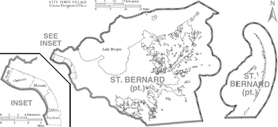
Map of St. Bernard Parish, Louisiana With Municipal Labels
There are no incorporated areas in St. Bernard Parish.
- Greater New Orleans
- Arabi
- Chalmette – parish seat and parish's population center
- Versailles
- Meraux
- Violet
- Eastern St. Bernard
- Caernarvon
- Contreras
- Delacroix Island
- Hopedale
- Kenilworth
- Poydras
- Reggio
- St.Bernard Village
- Shell Beach
- Toca
- Verret
- Yscloskey
Historical
- Fazendeville
- Proctorville
- St. Malo
Education
Public schools in the parish are operated by the St. Bernard Parish Public Schools agency.
Due to Hurricane Katrina, the parish's 20 plus public schools had been consolidated as one school, the St. Bernard Unified School, or SBUS. Starting in the 2006-2007 school year, the St. Bernard Unified School will break up into several different schools.
The parish is served by Nunez Community College.
As of 2011, the Public School System has expanded. Andrew Jackson High School was converted into an Elementary School. Lacoste Elementary has been converted into a Ninth Grade Academy. Trist Middle School is once again serving as a Middle School. If there are anymore, please add them.
Notable people
- P. G. T. Beauregard
- Walter Boasso
- Lynn Dean
- Albert Estopinal
- Albert Estopinal, Jr.
- Nita Rusich Hutter
- Samuel B. Nunez, Jr.
- Leander Perez
- Junior Rodriguez
See also
- National Register of Historic Places listings in St. Bernard Parish, Louisiana
References
- ^ "3 parishes' population estimates go way up in Census recalculation". January 15, 2009 article by The Times-Picayune. http://www.nola.com/news/index.ssf/2009/01/3_parishes_population_estimate.html. Retrieved 2009-01-15.
- ^ Din, Gilbert "The Canary Islanders of Louisiana", 1988
- ^ Barry, John M.. Rising Tide: The Great Mississippi Flood of 1927 and How It Changed America (1998 paperback ed.). New York: Touchstone Books. pp. 253–258. ISBN 0-684-84002-2.
- ^ "New Orleans population still cut by more than half". 29 November 2006 article by Reuters. http://www.alertnet.org/thenews/newsdesk/N29357330.htm. Retrieved 2006-12-06.
- ^ United States Census Bureau. "Louisiana Population of Counties by Decennial Census: 1900 to 1990". http://www.census.gov/population/cencounts/la190090.txt. Retrieved 2007-06-12.
- ^ "American FactFinder". United States Census Bureau. http://factfinder.census.gov. Retrieved 2008-01-31.
- ^ "Error: no
|title=specified when using {{Cite web}}". http://2010.census.gov.
External links
- Official website of the St. Bernard's Parish Government
- Official website of the St. Bernard Parish Tourist Commission
- St. Bernard Chamber of Commerce
- Los Isleños Heritage and Cultural Society
- St.Bernard Project Official Website
- St. Bernard Project Wikipedia Page
- H.O.P.E. Project of Violet, Louisiana
- Post-Katrina cleanup and volunteer efforts
- "Hurricane Journal", Samantha Perez of St. Bernard Parish
- St Bernard Health Statistics, History, and Vital Information
- Chalmation.net St. Bernard Internet Portal
- St. Bernard Parish Net Online Guide to St. Bernard Parish
- Geology and Hurricane-Protection Strategies in the Greater New Orleans Area
- Engineering Geology of St. Bernard Parish, Louisiana
| |||||||||||||||||

| ||||||||||||||||||||||||||
| This page uses content from the English language Wikipedia. The original content was at St. Bernard Parish, Louisiana. The list of authors can be seen in the page history. As with this Familypedia wiki, the content of Wikipedia is available under the Creative Commons License. |