| ||||||||||||||
| Tiruvallur district திருவள்ளூர் மாவட்டம் |
|
|---|---|
| — District — | |
 |
|
 |
|
| Coordinates: Coordinates: | |
| Country | |
| State | Tamil Nadu |
| Metro | |
| Headquarters | Tiruvallur |
| Talukas | Ambathur, Gummidipoondi, Madhavaram, Pallipattu, Ponneri, Poonamallee, Tiruttani, Tiruvallur, Uthukottai. |
| Government | |
| • Collector | K. Veera Raghava Rao, IAS |
| Area | |
| • Total | 3,422 km2 (1,321 sq mi) |
| Population (2011) | |
| • Total | 3,725,697 |
| • Rank | 4 |
| • Density | 1,049/km2 (2,720/sq mi) |
| Languages | |
| • Official | Tamil |
| Time zone | IST (UTC+5:30) |
| PIN | 601001, 602001[1] |
| Telephone code | 044 |
| Vehicle registration | TN-18/20[2] |
| Largest city | Ambattur (Chennai) |
| Largest metro | Ambattur (Chennai) |
| Sex ratio | 983 ♂/♀ |
| Literacy | 83.33% |
| IUCN category | |
| Central location: | |
| Avg. summer temperature | 37.9 °C (100.2 °F) |
| Avg. winter temperature | 18.5 °C (65.3 °F) |
| Website | tiruvallur.tn.nic.in |
Tiruvallur district (Tamil: திருவள்ளூர் மாவட்டம்) is an administrative district in the South Indian state of Tamil Nadu. The town of Thiruvallur is the district headquarters. The district has a mixture of urban and rural characteristics. The Eastern part of Tiruvallur district is dominated by urban characteristics while the Southern and Northern part of the district has influence of Andhra culture due to its position. The languages spoken in the district are Tamil, Telugu, Urdu and Malayalam. The district is dominated by the Hindus while people belonging to other religions are also present.
The district has been divided into three revenue divisions viz, Tiruvallur, Tiruttani and Ponneri. There are three taluks under Thiruvallur division, two taluks under Tiruttani divisions and four taluks under Ponneri division. There are 46 firkas and 820 revenue villages. Likewise there are 14 blocks, 12 Municipalities and 13 town panchayats which implement rural development activities.
Etymology[]
The word "Tiruvallur" is supposedly derived from the Tamil sentence "tiru evvull?" meaning, "Tiru" - god (a common prefix in South India for temple towns), "evvull" - where do I sleep. So, Tiruvallur means, a place/town where, the god, Veera Raghavar asked a saint for a place to sleep for a night.[3]
History[]
Tiruvallur was originally known as Tiruvallur which specifies the sleeping position of the holy lord "Balaji", in the Veeraragava temple of Tiruvallur. Later people began to refer it by names such as Trivellore and Tiruvallur. Today Tiruvallur is well known, one of the reason being the Veeraragava Temple. The new moon day is very auspicious day for the lord and so for the people of the town.
The district of Tiruvallur has been carved out by bifurcating erstwhile Chengalpattu district (which was renamed as Chengalpattu-MGR/Kancheepuram at the time of 1991 Census). According to the said bifurcation Tiruvallur revenue division which included Tiruvallur, Tiruttani taluks and Uthukkottai and Pallipattu sub-taluks separated from Chengalpattu district along with Ponneri and Gummindipoondi taluks of Saidapet revenue division and formed this new district. At present this district comprises nine taluks, namely Ambattur, Gummindipoondi, Ponneri, Uthukkottai, Tiruvallur, Poonamallee, Tiruttani, Pallipattu, and Madhavaram.
In the far past, this region was under a chain of regimes commencing from the Pallavas during the 7th century ending with the Nawab of Arcot during the early part of 19th century when it came under the British rule. In 1687, the Golkonda rulers were defeated and the region came under the Moghul emperors of Delhi. The towns and villages of this region were the scene of Carnatic wars. Battles are said to have been fought in this region during the struggle for supremacy between the English and French. The town of Pulicat was the earliest Dutch possession in India founded in 1609 which was ceded to the British in 1825. With this, the region came under the British rule which ended on the 15th August, 1947 with India becoming independent.[3]
Geography[]
It is bounded on the north by Andhra Pradesh state, on the east by the Bay of Bengal, on the southeast by Chennai district, on the south by Kanchipuram and on the west by Vellore district.The coastal region of the district is mostly flat and dreary; but in the other parts it is undulating and even hilly in some places.
The northern taluks of the district like Ponneri, Uttukkottai, Gummidipundi etc. do not have much to offer from the scenic point of view. In the Tiruttani taluk, a number of hillocks are found scattered. The soil of the district is mostly sandy, mixed with soda or other alkali or stony. Rocks found in and near the surface are in detached masses. Hence, the soil can't be termed as very fertile. The soil found nearer the sea coast is of the inferior erinaceous type which is most suited for raising casuarinas plants. No mineral of any importance is available in the district. There are not many hills of any considerable height in this district. A few conical hills or ridges of small elevation exist like the St. Thomas Mount. Certain hillocks are found in Tiruttani. Most of the hills and hillocks are rocky and no verdant vegetation is seen in the slopes of these hills. The area under forests in this district is quite meager.
The average normal rainfall of the District is 1104 mm. Out of which 52% has been received during North East Monsoon period and 41% has been received during South West Monsoon period.
Climate[]
| Climate data for Chennai | |||||||||||||
|---|---|---|---|---|---|---|---|---|---|---|---|---|---|
| Month | Jan | Feb | Mar | Apr | May | Jun | Jul | Aug | Sep | Oct | Nov | Dec | Year |
| Average high °C (°F) | 28.9 (84.0) |
30.6 (87.1) |
32.7 (90.9) |
34.7 (94.5) |
37.5 (99.5) |
37.3 (99.1) |
35.4 (95.7) |
34.5 (94.1) |
33.9 (93.0) |
31.9 (89.4) |
29.5 (85.1) |
28.5 (83.3) |
37.5 (99.5) |
| Average low °C (°F) | 20.4 (68.7) |
21.2 (70.2) |
23.1 (73.6) |
25.8 (78.4) |
27.6 (81.7) |
27.4 (81.3) |
26.2 (79.2) |
25.6 (78.1) |
25.3 (77.5) |
24.3 (75.7) |
22.7 (72.9) |
21.2 (70.2) |
20.4 (68.7) |
| Rainfall mm (inches) | 34.5 (1.358) |
12.5 (0.492) |
15.3 (0.602) |
17.7 (0.697) |
42.9 (1.689) |
53.7 (2.114) |
100.8 (3.969) |
129.2 (5.087) |
125.3 (4.933) |
290.9 (11.453) |
348.9 (13.736) |
145.6 (5.732) |
1,317.3 (51.862) |
| Avg. rainy days | 2.7 | 0.9 | 0.7 | 1.1 | 2.4 | 7.5 | 12.8 | 14.2 | 10.2 | 13.5 | 12.9 | 8.4 | 87.3 |
| Mean daily sunshine hours | 8.7 | 9.6 | 9.5 | 9.7 | 9.0 | 6.8 | 6.0 | 6.2 | 6.6 | 6.3 | 6.1 | 6.6 | 7.6 |
| Source #1: WMO [4] | |||||||||||||
| Source #2: HKO (sun only, 1971–1990) [5] | |||||||||||||
Demographics[]
According to the 2011 census Tiruvallur district has a population of 3,725,697,[6] roughly equal to the nation of Liberia[7] or the US state of Oklahoma.[8] This gives it a ranking of 70th in India (out of a total of 640).[6] The district has a population density of 1,049 inhabitants per square kilometre (2,720 /sq mi) .[6] Its population growth rate over the decade 2001-2011 was 35.25%.[6] Thiruvallur has a sex ratio of 983 females for every 1000 males,[6] and a literacy rate of 83.82%.[6]
It occupies an area of 3424 km² and has a population of 2,754,756 as of 2001. It is 54.45% urbanised.[9]
Economy[]
Tiruvallur district is one of the fastest developing districts in Tamil Nadu in terms of Industrial Development. The district has many leading industries like Madras Refineries, Madras Fertilizers, Manali Petro Chemicals, MRF, Ashok Leyland, TI Cycles, Britannia India Ltd, Parry India Ltd and Hindustan Motors. It also boasts of the Ennore Thermal Power Station and the Avadi Tank Factory. The District has 16 Industrial Estates, all in operation : 11 developed by the Government and 5 by Private Organisation.
Government[]
- Ambattur Industrial Estate, Ambattur.
- Electrical Industrial Estate, Kakalur.
- SIDCO Industrial Estate, Chennai - 98.
- Industrial Estate, Madhavaram.
- SIDCO Industrial Estate, Kakalur
- Petrochemical Industrial Estate, Vichoor
- SIDCO Industrial Estate, R.K. Pet
- SIDCO Industrial Estate, Gummidipoondi
- Industrial Estate, Mugappair
Private[]
- G.K. Industrial Estate, Porur
- M.M.Industrial Estate, Alapakkam
- Moccaram Industries, Velappan Chavadi
- Nagappa Industrial Estate, Puzhal
- Ekambara Naicker Industrial Estate, Alapakkam
This district has 16940 Small Scale Industries, notable among them being food, wood, textile, chemical, engineering, non-metallic and leather industries.
Administration[]
The following are the Taluks of the district.
- Tiruvallur
- Poonamallee
- Ponneri
- Gummidipoondi
- Uthukottai
- Tiruttani
- Pallipattu
- Ambattur
- Madhavaram
There are 12 Municipalities
- Ambattur
- Avadi
- Kattivakkam
- Madavaram
- Maduravayal
- Manali
- Poonamallee
- Tiruttani
- Tiruvallur
- Tiruverkadu
- Tiruvottiyur
- Valasaravakkam
Economy[]
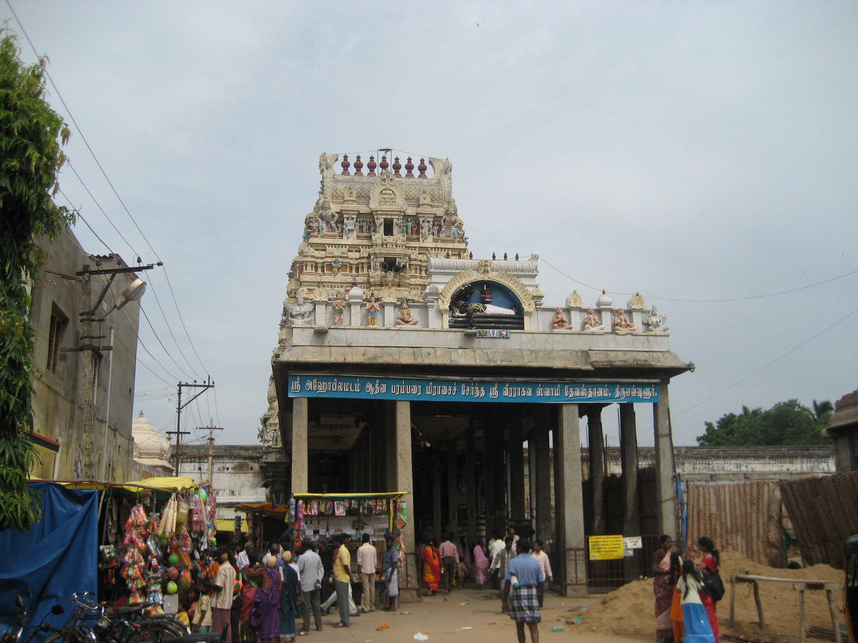
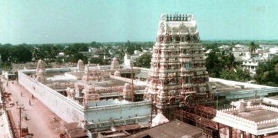
The Veera Raghava Swami Temple in Tiruvallur
In retail spending, the Thiruvallur district emerges third in India, only after Noida and SW Delhi surpassing Bangalore and Mumbai by a clear margin.[10]
Administration and Politics[]
| Assembly Constituency |
Political Party |
Elected Representative |
|---|
| Gummidipoondi | DMDK | C. H. Shekar |
| Ponneri | AIADMK | Pon. Raja |
| Tiruvottiyur | AIADMK | K. Kuppan |
| Ambattur | AIADMK | S. Vedachalam |
| Poonamallee | AIADMK | R. Manimaran |
| Tiruvallur | AIADMK | B. V. Ramanaa |
| Madavaram | AIADMK | Moorthy |
| Maduravoyal | CPI-M | Bhima Rao |
| Tiruttani | DMDK | M. Arun Subramanian |
| Lok Sabha Constituency |
Political Party |
Elected Representative |
|---|
| Thiruvallur | AIADMK | P. Venugopal |
| Source: Indian Elections / Election Commission of India.[11][12] | ||
Tiruvallur assembly constituency is part of Tiruvallur (Lok Sabha constituency).[13]
Tiruvallur Assembly Constituency Elected member - Mr.Ramana of AIADMK
Mr. Ramana sworned in as Minister for Handlooms and Textiles after AIADMK washed out Ex-ruling party DMK in the elections.
Currently Mr. Ramana is Minister for Commercial Taxes and Registration which has been revoked from Mr Agri S.S.Krishnamoorthy.
References[]
- ^ Tamil Nadu post
- ^ www.tn.gov.in
- ^ a b tiruvallur official website
- ^ "World Weather Information Service - Chennai". World Meteorological Organisation. http://worldweather.wmo.int/066/c00527.htm. Retrieved 4 May 2011.
- ^ "Climatological Information for Madras, India". Hong Kong Observatory. http://www.hko.gov.hk/wxinfo/climat/world/eng/asia/india/madras_e.htm. Retrieved 4 May 2011.
- ^ a b c d e f "District Census 2011". Census2011.co.in. 2011. http://www.census2011.co.in/district.php. Retrieved 2011-09-30.
- ^ US Directorate of Intelligence. "Country Comparison:Population". https://www.cia.gov/library/publications/the-world-factbook/rankorder/2119rank.html. Retrieved 2011-10-01. "Liberia 3,786,764 July 2011 est."
- ^ "2010 Resident Population Data". U. S. Census Bureau. http://2010.census.gov/2010census/data/apportionment-pop-text.php. Retrieved 2011-09-30. "Oklahoma 3,751,351"
- ^ Census 2001
- ^ Times of India, Bangalore dated Aug 24, 2006
- ^ "Election results". Indian Elections. http://www.indian-elections.com/assembly-elections/tamil-nadu/election-result-06.html.
- ^ "Parties Statistics". Election Commission of India. http://www.eci.gov.in/StatisticalReports/ElectionStatistics.asp.
- ^ "List of Parliamentary and Assembly Constituencies" (PDF). Tamil Nadu. Election Commission of India. http://archive.eci.gov.in/se2001/background/S22/TN_ACPC.pdf. Retrieved 2008-10-08.
External links[]

|
Chittoor district, Andhra Pradesh | Nellore district, Andhra Pradesh |
| |
| Bay of Bengal | ||||
 Tiruvallur district | ||||
| Vellore district | Kanchipuram district | Chennai district |
| ||||||||||||||||||||||||||||||||||||||||
Template:Tiruvallur district
| This page uses content from the English language Wikipedia. The original content was at Tiruvallur district. The list of authors can be seen in the page history. As with this Familypedia wiki, the content of Wikipedia is available under the Creative Commons License. |