| Traunstein District | |||
|---|---|---|---|
| — District — | |||
|
|||
 |
|||
| Country | |||
| State | Bavaria | ||
| Adm. region | Upper Bavaria | ||
| Capital | Traunstein | ||
| Area | |||
| • Total | 1,533.92 km2 (592.25 sq mi) | ||
| Population (31 December 2010)[1] | |||
| • Total | 170,521 | ||
| • Density | 110/km2 (290/sq mi) | ||
| Time zone | CET (UTC+1) | ||
| • Summer (DST) | CEST (UTC+2) | ||
| Vehicle registration | TS | ||
| Website | http://www.traunstein.com | ||
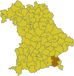
Traunstein is a Kreis (district) in the southeastern part of Bavaria, Germany. Neighboring districts are (from the north clockwise) Mühldorf am Inn, Altötting, the Austrian states Upper Austria and Salzburg, the district Berchtesgadener Land, the Austrian states of Salzburg and Tyrol, and the district Rosenheim.
Geography[]
The district is located in the northern foothills of the Alps. The Chiemsee is located in the west of the district.
History[]
In 1972 the district was merged with parts of the former district Laufen, and the previously independent urban district Traunstein.
Coat of arms[]

|
The coat of arms shows a blue panther to the left, the symbol of the Spanheim dynasty of the Counts of Krainburg-Ortenburg, who owned part of the area in medieval times. The eagle in the top-right derives from the diocese of Chiemsee. In the bottom right there are the Canting Arms of Baumburg Abbey (Baumburg translates to tree-castle), which ruled most of the northern part of the district. |
Towns and municipalities[]
| Towns | Municipalities | |
|---|---|---|
Markt
¹ administrated inside a Verwaltungsgemeinschaften
|
|
|
References[]
- ^ "Fortschreibung des Bevölkerungsstandes" (in German). Bayerisches Landesamt für Statistik und Datenverarbeitung. 31 December 2010. https://www.statistikdaten.bayern.de/genesis/online?language=de&sequenz=tabelleErgebnis&selectionname=12411-009r&sachmerkmal=QUASTI&sachschluessel=SQUART04&startjahr=2010&endjahr=2010.
External links[]
Wikimedia Commons has media related to:
- Official website (German)