| Uttara Kannada | |
|---|---|
| — district — | |
 |
|
 |
|
| Coordinates: Coordinates: | |
| Country | India |
| State | Karnataka |
| Region | Konkan |
| Headquarters | Karwar |
| Talukas | Karwar, Ankola, Kumta, Honnavar, Bhatkal, Sirsi, Siddapur, Yellapur, Mundgod, Haliyal, Joida |
| Government | |
| • Deputy Commissioner | Imkongla Jamir |
| Area | |
| • Total | 10,291 km2 (3,973 sq mi) |
| Population (2011) | |
| • Total | 1,436,847 |
| • Density | 140/km2 (360/sq mi) |
| Languages | |
| • Official | Kannada |
| Time zone | IST (UTC+5:30) |
| PIN | 581xxx |
| Telephone code | +91 0(838x) |
| Vehicle registration | Karwar KA 30
|
| Coastline | 142 kilometres (88 mi) |
| Sex ratio | 0.975[1] ♂/♀ |
| Literacy | 84.03% |
| Lok Sabha constituency | Kanara Lok Sabha constituency |
| Climate | Mansoon (Köppen) |
| Precipitation | 2,835 millimetres (111.6 in) |
| Avg. summer temperature | 33 °C (91 °F) |
| Avg. winter temperature | 20 °C (68 °F) |
| Website | uttarakannada.nic.in |
Uttara Kannada, also known as North Kanara or North Canara, is a Konkan district in the Indian state of Karnataka. It is bordered by the state of Goa and Belgaum District to the north, Dharwad District and Haveri District to the east, Shimoga District and Udupi District to the south and the Arabian Sea to the west. The city of Karwar is the administrative headquarters of the district.
History[]
Kali River & Sadashivgad Fort as seen from Nandangadda Village
Uttara Kannada was the home of the Kadamba kingdom from the 350 to 525. They ruled from Banavasi. After the subjugation of the Kadambas by the Chalukyas, the district came under successive rule of empires like Chalukyas, Rashtrakutas, Hoysalas and Vijayanagar empire. Famous Moroccan traveler Ibn Battuta is said to have stayed for a time in the district under the protection of Nawayath Sultan Jamal Al-Din at Hunnur. This place is presently known as Hosapattana and is located in the town of Honnavar. Ruins of an old mosque and its minaret can still be seen in the village. The district came under the rule of Maratha Empire in the 1800s, who ceded it to the British at the conclusion of the Third Anglo-Maratha War in 1818. The British established Uttara Kannada district as a part of the Bombay Presidency.
After India's independence in 1947, Bombay Presidency was reconstituted as Bombay State. In 1956 the southern portion of Bombay State was added to Mysore State, which was renamed Karnataka in 1972. Uttara Kannada was an ancient site of sea trade visited by the Arabs, Dutch, Portuguese, French and later the British. Ibn Battuta passed through this route during one or more of his journeys.
Significant and picturesque, the Sadashivgad fort of historical importance is now a popular tourist destination located by the Kali river bridge, which has been built at the confluence of the river and the Arabian Sea. The renowned Bengali poet and Nobel laureate Rabindranath Tagore, who visited Uttara Kannada in 1882, dedicated an entire chapter of his memoirs to this town.[2] The 22 year old Rabindranath Tagore stayed with his brother, Satyendranath Tagore, who was the district judge in Uttara Kannada. There is a substantial amount of Chardo families in this area as they had migrated due to the persecution of the Portuguese in Goa.
Portuguese[]
Cintacora, also known as Chitrakul (Chittakula) and Sindpur, was known to the Portuguese as a very old port. When Sadashivgad was built in this area, the village also came to be known by that name. Pir fort, named for the Dargah of Shahkaramuddin, was captured and burnt by the Portuguese in 1510. The creek at the mouth of the Kali River was a trading center which came into greater prominence after Sadashivgad was built and the Portuguese realised the advantages of its sheltered harbor.
British[]
In 1638 a rival English trading body, the Courteen Association, established a factory at Uttara Kannada (actually the village named Kadwad, situated 6 kilometres (3.7 mi) eastwards on the banks of the Kali river). It was a trade port frequented by traders from Arabia and Africa. Baitkhol port (the current civil port of Uttara Kannada) was famous for its natural harbor. The name Baithkhol is Arabic term, Bait-e-kol, meaning bay of safety. Muslin was the chief commodity purchased but Uttara Kannada was also a source for Pepper, Cardamom, Cassier and coarse blue cotton cloth. Situated on India's west coast, 50 miles south-east of Goa, Uttara Kannada was noted for its safe harbor. In 1649 the Courteen Association united with the British East India Company and Uttara Kannada became a Company factory.
Kingdom of Mysore[]
In the Treaty of Mangalore signed in 1784, between Tipu Sultan and the East India Company, one finds reference to Uttara Kannada and Sadashivgad written as Carwar and Sadasewgude respectively.[3]
The British Empire[]
The British made Uttara Kannada their district headquarters in 1862. Since 1862, the time from which it came under Bombay Presidency, Uttara Kannada was described as a first rate harbor between Bombay and Colombo.
Maratha Empire[]
Uttara Kannada was a part of the Maratha Empire during the 18th century. After the defeat of the Marathas in the Third Anglo-Maratha War, it became a part of British territory. It was a part of the Bombay Presidency until 1950.
Geography and Climate[]
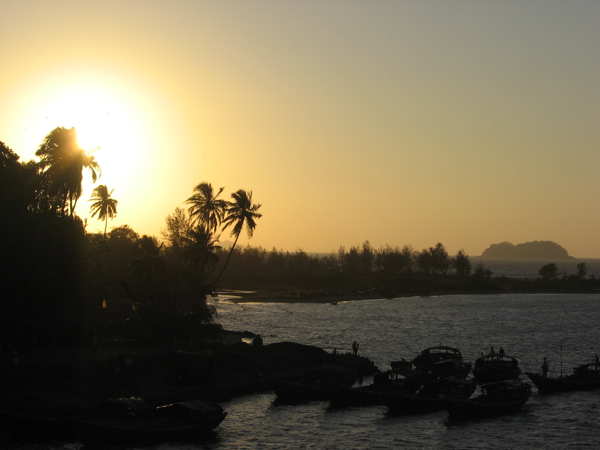
Karwar Evening
The main geographic feature of the district is the Western Ghats or Sahyadri range, which runs from north to south through the district. Between the Sahyadris and the sea is a narrow coastal strip, known as the Payanghat, which varies from 8 to 24 kilometres (5.0 to 15 mi) in width. Behind the coastal plain are flat-topped hills from 60 to 100 meters in height, and behind the hills are the ridges and peaks of the Sahyadris. East of the Sahyadris is the Balaghat upland, part of the vast Deccan plateau. Moisture-bearing winds come from the west, and yearly rainfall averages 3,000 millimetres (120 in) on the coast, and as high as 5,000 millimetres (200 in) on the west-facing slopes of the Sahyadris. East of the crest is the rain shadow of the Sahyadris, which receive as little as 1,000 millimetres (39 in) annually. Much of the rain falls in the June–September Monsoon. Four principal rivers drain westwards from the crest of the Sahyadris to the sea; from north to south they are the Kali, Gungawali, Aghanashini and Sharavati. These rivers form numerous waterfalls, the most famous of which is Jog falls, on upper reaches of the Sharavati in neighboring Shimoga district, other famous waterfalls include Unchalli Falls, where the river Aghanashini drops 116 meters, Magod Falls, where the Bedti river plunges 180 meters in two leaps, Shivganga falls, where the river Sonda (Shalmali) drops 74 meters, and Lalguli falls and Mailmane falls on the river Kali. In the lowlands, these rivers form wide estuaries, extending several kilometers inland from the coast.
Ecology[]
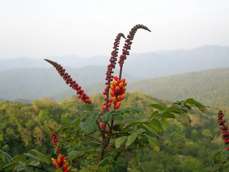
Candy Corn Plant in the Anshi National Park
The district's high rainfall supports lush forests, which cover approximately 70% of the district. The North Western Ghats moist deciduous forests cover the Sahyadris below 1000 meters elevation. Many trees shed leaves in the drier months. In pockets above 1000 meters elevation lie the evergreen North Western Ghats montane rain forests. Anshi National Park near Dandeli, preserves approximately 250 square kilometres (97 sq mi) of semi-evergreen forest, which is home to the Tiger, Black Panther, Leopard Cat, Gaur, Asian Elephant, sambar and a range of birds and reptiles. Dandeli Wildlife Sanctuary protects 834 square kilometres (322 sq mi) of semi-evergreen and Bamboo forest in the watershed of the Kali river and its tributaries, the Kaneri and Nagajhari. The Wrought on free tailed bat is endemic to the forests of Bhimgad, a proposed wild life sanctuary. The district is also home to patches of Savanna and degraded scrub jungles, which are often the result of overuse for logging or grazing. Much of the lowland has been cleared for agriculture. Mangrove forests can be found in the river estuaries, and the sandy beaches are home to groves of Calophyllum Inophyllum, Coconut and Screw pine (Pandanus). The rocky beaches at Binaga, Arga, Belekeri, Tadadi, Ankola, Kumta, Dhareshwar, Kasarkod, Murdeshwara, Bhatkal and Belke of the district are rich with Marine Fauna Diversity. The rocky beaches of Uttara Kannada District harbor the invertebrates belonging to the Phylum Porifera, Coelenterata, Annelida, Arthropoda, Mollusca and Echinodermata. Attiveri bird sanctuary is home to 79 species of birds including migratory birds from 22 countries. Dandeli Wildlife Sanctuary is famous for the elusive Black Panther among other animals like Gaur, Tiger and Leopards. The Kavala caves with their 5 feet (1.5 m). High natural Shiva linga, Synthery rocks is a 500 feet (150 m) high rock flanked by natural caves and waterfalls, Vincholi rapids, Sykes point which offers a view of Kali river, and a suspension bridge are places worth visiting in this sanctuary. Yana is an enchanting place that can be reached by trekking about 10 kilometres (6.2 mi) through lush forest. It is famous for its tall jagged rock formations and waterfalls. There is also a shrine of Bhairaveshvara here. Anshi National Park located some distance from Dandeli is undisturbed. Burude Falls is about 20 kilometres (12 mi) from Siddapur, Unchalli Falls, Shivagangae, BeeneHolae Fall is about 25 kilometres (16 mi) from Sirsi, Magod Falls and Sathodi Falls near Yellapura are some of the best natural falls in Uttara Kannada District. There are many dams in this district namely Supa Dam, Kodasalli Dam and Kadra Dam. The famous Atomic energy station at Kaiga is on the beautiful banks of River Kali.
Culture[]
Language and Religion[]
The Main Languages spoken in this District are Kannada, Konkani & Marathi. Kannada is spoken as a local and Predominant language in Uttara Kannada District. Konkani comes Next which is also widely spoken language in Uttara Kannada District. Although some of the people in Uttara Kannada have their mother tongue as Konkani. Konkani speakers in Uttara Kannada are bilingual; they are well conversant in Kannada as well as in Konkani.Some of them are also conversent in Marathi too. Marathi is spoken & widely understood in district due to the prevalence of Marathi Literature and arts in this area. Urdu, Hindi and English are also used in social communication. The population is predominantly Hindu composed of majority communities.The main tribes of the district are Namadhari Naiks, Halakki Vokkaligas, Kannada Vaishyas, Gudigars, Siddis, Komarpant, Shervegar Naayaks, Nadavas, Kunabis, Gondas and Gavlis.Others are Havyaka Brahmins, Goud Saraswat Brahmins, Padyes, Daivadnya Brahmins, Chitrapur Saraswat Brahmins, Rajapur Saraswat Brahmins, Chitpavan Brahmins, Kudaldeshkar Gaud Brahmans, Kramavant Joshis, Marathas, Vaishya Vanis, Konkan Marathas, Charis, Gomantak Maratha Samaj, Nutan Maratha Samaj, Naik Maratha Samaj, Bhandaris, Kharvis, Madvals. The people of Uttara Kannada are non-vegetarians except for Havyaka community. Muslims are spread out in Uttara Kannada, community of Nawayath live mostly in taluks of Bhatkal, Kumta and Honnavar. The Community speaks a dialect called ‘Nawayathi’. It is an amalgam of Persian, Arabic, Marathi and Urdu with Konkani as its base. The Nawayath language uses Persian script for writing,it is interesting to note that "Persian script" was being used to write by the Nawayath's long before the language Urdu came into existence. Dakhini Muslims, Konkani Muslims and Nawayath Muslims live together united. Uttara Kannada Muslim men are generally light skinned, and their attire consists of Jubba (A shirt almost knee length) / Shirt, and lungi. Women have generally adopted the local way of dressing, however they observe strict Burkah (Islamic Veil). Anklets and nose studs are not a common practice. In fact its discouraged. Christians of Catholic and Protestant faiths are also thinly spread over the district Goan Catholics and Karwari Catholics.
Dance[]
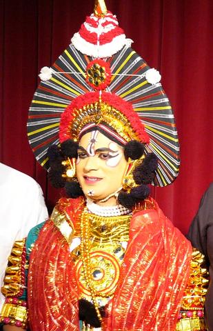
Yakshagana is a classical dance drama popular in the state of Karnataka in India mostly popular in the districts of Uttara Kannada. Shimoga, Udupi, South Kanara and Kasaragod district of Kerala. This theater art involves Music, Songs, Dance, Acting, Dialogue, Story and unique costumes. While, songs and dance adhere to well established talas very similar to classical Indian dance forms, acting and dialogues are created spontaneously on stage depending on ability of artists. This combination of classical and folk elements makes Yakshagana unique from any other Indian art. This would be considered to be a form of opera in western eyes. Traditionally, Yakshaganas use to start late in the night and run entire night. Bagavatha, the background singer is also the directory of the story and controls the entire proceedings on stage. Bagavatha along with background musicians who play Chande and Maddale forms himmela. The actors who ware colorful costumes and enact various roles in the story forms Mummela. There are many professional troops in Karnataka. In spite of competition from modern movie industry and TV, these troops are arranging ticketed shows and making profit. Apart from this individuals arrange shows in their village inviting well known professional artists like Sri Chittani Ramachandra Hegde and Kondadakuli Ramachandra Hegde, providing an opportunity for local talents to act with legends. Yakshagana is sometimes simply called as Aataā in both Kannada and Konkani (meaning play).[4] Yaksha-gana literally means the song (gana) of a Yaksha. Yakshas were an exotic tribe mentioned in the Sanskrit literature of ancient India.[5]
Economy[]
Agriculture[]
The chief crops of the district are Rice and Arecanut, along with a great diversity of other crops. Tree crops include Coconut, Sugar Cane, Cocoa, Cashew, Mango, Banana, Pineapple, Garcinia, and Sapota; vegetables include Onion, radish, Cucumber, Cauliflower, Sweet Potato, Brinjal, and Amaranth; spices include Pepper, Cardamom, Ginger and Nutmeg. Millet and Cotton are grown in the drier portion of the district east of the Western Ghats.
Industries[]
The major products of small scale industries in Uttara Kannada are Roofing Tiles, Coir Products, Jewelry, Food Products, Wood and Steel Furniture, Glass and Ceramics and Seafood. Some of these SSI and Tiny industries provide Job Works, components and spares required for large and medium scale industries, both within and outside the district. Eight large and medium scale industries in the district produce a variety of products like Paper, Duplex Board, Caustic Soda, Ferro Alloys, Transmission Gears, Food Concentrate, Herbal Medicines and Pharmaceuticals.
Towns[]
|
|
|
Demographics[]
According to the 2011 census Uttara Kannada has a population of 1,436,847,[1] roughly equal to the nation of Swaziland[6] or the US state of Hawaii.[7] This gives it a ranking of 346th in India (out of a total of 640).[1] The district has a population density of 140 inhabitants per square kilometre (360 /sq mi). Its population growth rate over the decade 2001-2011 was 6.15%. Uttara Kannada has a sex ratio of 975 females for every 1000 males, and a literacy rate of 84.03%.[1]
Festivals[]
Diwali is celebrated by Hindus as the return of Rama, King of Ayodhya, with his wife Sita and brother Lakshmana to Ayodhya after 14 years exile, and a war in which he killed Ravana. It is also called the Festival of Lights. All homes, shops, establishments & offices are decorated & special arrangements are made at night for lighting.
The traditional Islamic festivals of Eid ul-Fitr (Ramadan) and Eid ul-Adha (Bakrid) are celebrated. Special Eid prayer is offered during these two occasions. Usually in the central Eidgah the Qadhi leads the Eid prayer and delivers Khutba. Colourful costumes, delicious Food, exchanging the Eid greetings – Eid Mubarak (Arabic/Persian/Urdu: عید مبارک), Fasting (Roza), generous charity to the poor and needy are part of Eid celebration. Other occasions celebrated are 12th Rabi' al-awwal of the third month of Islamic calendar.
Cuisine[]

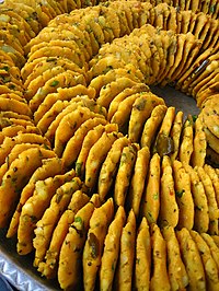
Batata Vada
Uttara Kannada is famous for a variety of seafood delicacies. Fish curry and rice is the staple diet of the locals, Cashews and Coconut.
The traditional foods of the Nawayathis are Rice, Fish, and Meat. The people of Nawayaths of Kumta, Honnavar and Bhatkal have adopted most of their foods from the surrounding regions including Kerala and other parts of India. Seafood has been the mainstay of the Nawayathi diet for centuries. Meat and Rice are other staple foods; Beef and Poultry are the more favoured Meats, then goat and lamb. Popular beverage is tea, which can be supplemented with cardamom or mint to give them a distinct flavour. Muslims are strictly prohibited from eating pork, so it is not included in local menus. Alcohol is also strictly prohibited in hotel and restaurants.
Newspapers and Media[]
- The District Media/News Center (Zilla Varta Kendra) is located near DC office, Karwar
- SahilOnline English Urdu & Konkani daily, Bhatkal
- Karavali Munjavu, Karwar
- Nagarika, Honnavar
- NudiJenu, Ankola
- Janantharanga, Kumta
- Konkani Vruththaa, Kumta
- Pathrakartha, Sirsi
- Janamadhyama, Sirsi
- Lokadhwani, Sirsi
- www.sirsi.in, Sirsi
- Agnashini Dhwani, Kumta
- Karavali Aley, Kumta
- Canara Vijay, Kumta
Transport[]
Public Transport[]
North West Karnataka Transport Corporation (NWKRTC) is the state transport agency in the district. The NWKRTC covers all towns & villages of the district. There is a good network of public transport which connects the villages to the towns of the district. There are regular intra state services to major cities & towns of the state like Bangalore, Mysore, Mangalore, Hubli-Dharwad & Belgaum. The Kadama Transport buses of neighboring Goa state provides regular service from Karwar to Mangalore and all part of Goa state. Kumta & Sirsi are the main hubs for public transport which provides services to intra-district & intrastate round the clock.
Many private transport buses also provide services for inter / intra state from the district. The NH-17 which passes through the district which connects Mumbai to Kerala state, many private buses are plying on this Highway which provides inter-intra state services to places like Mumbai, Pune, Kolhapur, Belgaum, Panaji, Margao, Udupi, Mangalore, Kasaragod & Kannur etc.
Highways[]
The following are the National Highways which passes through the district of Uttara Kannada.
- NH-17 which connects Edappally near Ernakulam in Kerala and Panvel near Mumbai, which start in the north of the district at Majali village & ends at Bhatkal.
- NH-206 which connects Honnavar and Bengalore
- NH-63 which connects Ankola and Hubli
- NH-17A which connects Dandeli and Vasco
Railways[]
The following Railways pass through the district:
- Konkan Railway which connects Mangalore and Mumbai via Karwar,
- Londa to 'Vasco Railway line which passes through Castle Rock
- Casle rock to Dandeli Railway line.
- Hubli -Ankola railway line is proposed to link Karwar port and the northern Karnataka.
- RO-RO (Roll on/Roll off) services is provided by Konkan Railway to / from Ankola railway station to Suratkal Railway station. Many truckers use this facility between Ankola to Mangalore.
Ports[]
Uttara Kannada being one of the coastal district of the Karnataka state has a coast of 120 kilometres (75 mi) has many ports which are used for Sea Trade, Naval base, Fishing & other maritime activities.
- Karwar Port is an intermediate sea port the main activities of this port are Berthing of Ocean Going Ships, Coastal Shipping, & Fishing Jetty. Ship bunkering facility is also available at Karwar port.
- INS Kadamba is a naval base at Arga village of Karwar which is used exclusively for berthing of naval vessels. A naval ship repair yard (Dry Docks) is also attached to it.
- Belkeri Port is an anchorage port.
- Tadri Port is a fishing port.
- Kumta Port is a fishing port.
- Honnavar Port is a fishing port.
- Bhatkal Port is a fishing port.
The Proposed Hubli-Ankola railway line can be feasible venture for the future developments of the ports in the district, for movement of the cargo, at present roads are only major mode of cargo movement which leads to congestion of the National Highways of the district.
Nearby Airports[]
- Hubli Airport
- Belgaum Airport
- Goa International Airport
- Mangalore International airport
Education Institutes[]
|
|
Notable People From The District[]
|
|
External links[]
- Official website
- SahilOnline English Daily Newspaper
- SahilOnline Urdu Daily Newspaper
- Karwar Online
- Karwar City Municipal Council
- Zilla panchayat Karwar
- Sirsi Online Info

|
South Goa District, Goa | Belgaum District | Dharwad District |
|
| Arabian Sea | Haveri District | |||
 Uttara Kannada District | ||||
| Arabian Sea | Udupi District | Shimoga District |
References[]
- ^ a b c d "Uttara Kannada (North Canara) : Census 2011". Government of India. http://www.census2011.co.in/census/district/269-uttara-kannada.html. Retrieved February 17, 2012.
- ^ Uttara Kannada in Tagore's memoirs
- ^ Project South Asia
- ^ "Enduring art". Online webpage of The Hindu (Chennai, India). 2004-06-10. http://www.hindu.com/mp/2004/06/10/stories/2004061000340300.htm. Retrieved 2007-09-06.
- ^ "yaksha". Encyclopædia Britannica. http://www.britannica.com/eb/article-9077732/yaksha. Retrieved 2007-09-06.
- ^ US Directorate of Intelligence. "Country Comparison:Population". https://www.cia.gov/library/publications/the-world-factbook/rankorder/2119rank.html. Retrieved 2011-10-01. "Swaziland 1,436,847"
- ^ "2011 Resident Population Data". U. S. Census Bureau. http://2011.census.gov/2011census/data/apportionment-pop-text.php. Retrieved 2011-09-30. "Hawaii 1,436,847"
Template:Uttara Kannada
| ||||||||||||||
| This page uses content from the English language Wikipedia. The original content was at Uttara Kannada. The list of authors can be seen in the page history. As with this Familypedia wiki, the content of Wikipedia is available under the Creative Commons License. |