| Main | Births etc |
|---|
| Wakefield | |
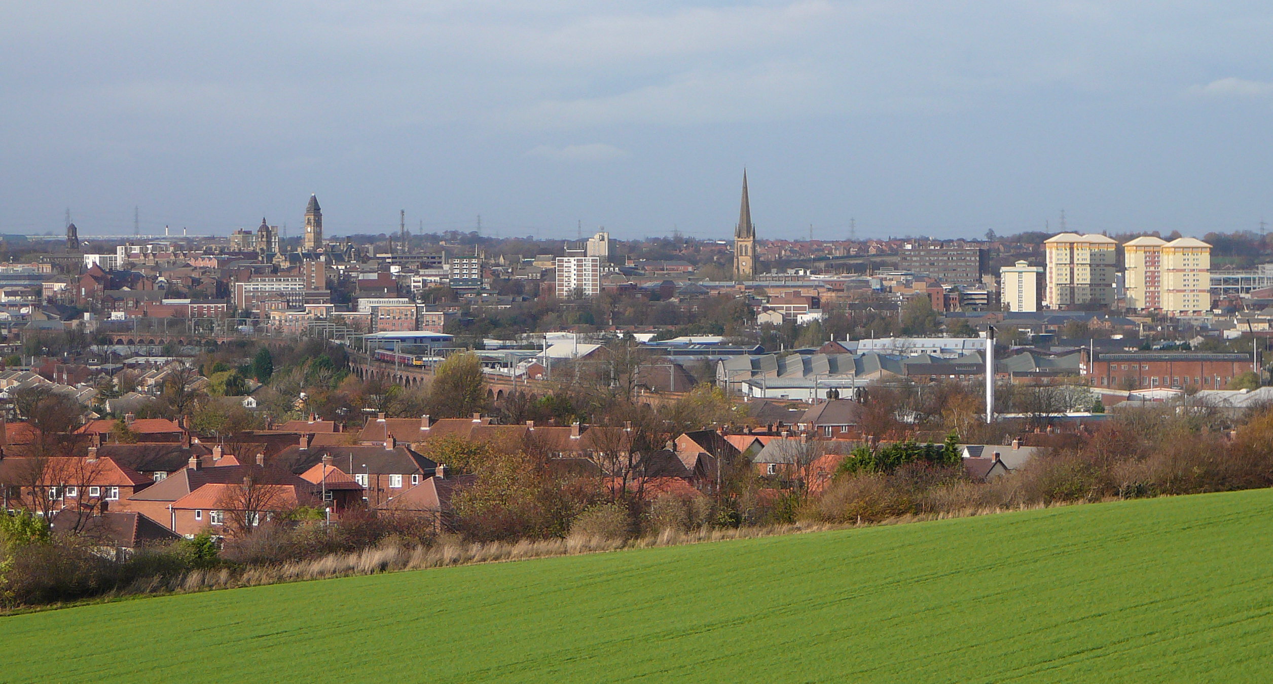 Wakefield city centre viewed from Sandal Castle |
|
Wakefield | |
| Population | 76,886 |
|---|---|
| OS grid reference | |
| Metropolitan borough | City of Wakefield |
| Metropolitan county | West Yorkshire |
| Region | Yorkshire and the Humber |
| Country | England |
| Sovereign state | United Kingdom |
| Post town | WAKEFIELD |
| Postcode district | WF1,WF2,WF3,WF4 |
| Dialling code | 01924 |
| Police | West Yorkshire |
| Fire | West Yorkshire |
| Ambulance | Yorkshire |
| EU Parliament | Yorkshire and the Humber |
| UK Parliament | Wakefield, Hemsworth |
| List of places: UK • England • Yorkshire | |
Wakefield is the main settlement and administrative centre of the City of Wakefield, a metropolitan district of West Yorkshire, England. Located by the River Calder on the eastern edge of the Pennines, the urban area is 2,062 hectares (5,100 acres) and had a population of 76,886 in 2001.[1]
Wakefield was dubbed the "Merrie City" in the Middle Ages[2] and in 1538 John Leland described it as, "a very quick market town and meately large; well served of fish and flesh both from sea and by rivers ... so that all vitaile is very good and chepe there. A right honest man shall fare well for 2d. a meal. ... There be plenti of se coal in the quarters about Wakefield".[nb 1]
The site of a battle during the Wars of the Roses and a Royalist stronghold during the Civil War, Wakefield developed in spite of setbacks to become an important market town and centre for wool, exploiting its position on the navigable River Calder to become an inland port.
During the 18th century Wakefield continued to develop through trade in corn, coal mining and textiles and in 1888 its parish church, with Saxon origins, acquired cathedral status. The county town became seat of the West Riding County Council in 1889 and the West Yorkshire Metropolitan Council in 1974.
History[]
Toponymy[]
The name "Wakefield" may derive from "Waca's field" – the open land belonging to someone named "Waca" or could have evolved from the Old English word wacu, meaning "a watch or wake", and feld, an open field in which a wake or festival was held.[4][5] In the Domesday Book of 1086, it was written Wachefeld and also as Wachefelt.
Early history[]


Wakefield Cathedral
Flint and stone tools and later bronze and iron implements have been found at Lee Moor and Lupset in the Wakefield area showing evidence for human activity since prehistoric times.[6] This part of Yorkshire was home to the Brigantes until the Roman occupation in 43 AD. A Roman road from Pontefract passing Streethouse, Heath Common, Ossett Street Side, Kirklees and on to Manchester crossed the River Calder by a ford at Wakefield near the site of Wakefield Bridge.[7] Wakefield was probably settled by the Angles in the 5th or 6th century and after 867 the area was controlled by the Vikings who divided the area into wapentakes. Wakefield was part of the Wapentake of Agbrigg. The settlement grew up near a crossing place on the River Calder around three roads, Westgate, Northgate and Kirkgate.[8] "Gate" derives from Old Norse gata meaning road[9] and kirk, from kirkja indicates there was a church.[10]
Before 1066 the manor of Wakefield belonged to Edward the Confessor and it passed to William the Conqueror after the Battle of Hastings.[11] After the Conquest Wakefield was a victim of the Harrying of the north in 1069, William the Conqueror's revenge for resistance to Norman rule by the local population. It was recorded as Wachfeld in the Domesday Book of 1086, and covered a much greater area than present day Wakefield, much of which was described as "waste".[12] The Manor of Wakefield, was granted by the crown to William de Warenne, 1st Earl of Surrey whose descendants, the Earls Warenne, inherited it when he died in 1088.[13] The building of Sandal Castle began early in the 12th century and it became the stronghold of the manor.[14] A second castle was built at Lawe Hill on the north side of the Calder but was abandoned.[15] Wakefield and its environs formed the caput of an extensive baronial holding by the Warennes that extended to Cheshire and Lancashire. The Warennes, and their feudal sublords, continued to hold the area until the 14th century, when it passed to Warenne heirs.[16] Norman tenants holding land in the region included the Lyvet family at Lupset.[17]


Duke of York Memorial, killed 1460
In 1086 the Domesday Book recorded two churches, one in Wakefield and one in Sandal Magna.[18] The Saxon church in Wakefield was rebuilt in about 1100 in stone in the Norman style and was continually enlarged until 1315 when the central tower collapsed. By 1420 the church was again rebuilt and was extended between 1458 and 1475. In 1203 William de Warenne, 5th Earl of Surrey received a grant to have a market in Wakefield.[19] In 1204 King John granted the rights for a fair to be held at the feast of All Saints, 1 November, and in 1258 Henry III granted another fair to be held on the feast of St. John the Baptist, 24 June. The market was situated close to the Bull Ring and the church.[19] The townsfolk of Wakefield amused themselves in games and sports earning the title "Merrie Wakefield", the chief sport in the 14th century was archery and the butts in Wakefield were at the Ings, near the river.[20]
In 1460, during the Wars of the Roses, the Duke of York was killed on 30 December 1460 in the Battle of Wakefield near Sandal Castle. As preparation for the impending invasion by the Spanish Armada in April 1558, 400 men from the wapentake of Morley and Agbrigg were summoned to Bruntcliffe near Morley with their weapons. Men from Kirkgate, Westgate, Northgate and Sandal were amongst them and all returned by August.[21] At the time of the Civil War Wakefield was a Royalist stronghold, an attack led by Sir Thomas Fairfax on 20 May 1643 captured the town for the Parliamentarians. Over 1500 troops were taken prisoner along with the Royalist commander, Lieutenant-General Goring.[22]
In medieval times Wakefield had become a port on the River Calder and centre for the woollen and tanning trades. In 1699 an Act of Parliament was passed creating the Aire and Calder Navigation which provided Wakefield with access to the North Sea.[23] The first Registry of Deeds in the country opened in 1704 and in 1765 Wakefield's cattle market was established and became the one of largest in the north. The town was a centre for cloth dealing with its own piece hall, the Tammy Hall, built in 1766.[3] In the late 1700s Georgian town houses were built around St John's Church which was built in 1795.[23][24]
Later history[]


Wakefield Westgate c. 1900
At the start of 19th century Wakefield was already a wealthy market town and inland port trading in wool and corn.[25] The Aire and Calder and Calder and Hebble Navigations and the Barnsley Canal were instrumental in the development of Wakefield as an important market for corn from Norfolk, Cambridgeshire and Lincolnshire supplying the fast growing population in the West Riding. The Corn Exchange opened in Westgate in 1838.[26] The market developed in the streets around the Bull Ring and the cattle market between George Street and Ings Road grew to be one of the biggest in the country.[27] Road transport using turnpiked roads was also important. Regular mail coaches departed to Leeds, London, Manchester, York and Sheffield and the 'Strafford Arms' was an important coaching inn.[28] The railways arrived in Wakefield in 1840 when Kirkgate Station was built on the Manchester to Leeds line.
When cloth dealing declined, wool spinning mills using steam power were built by the river. There was a glass works in Calder Vale Road, several breweries including Melbourne's and Beverley's Eagle Brewery, engineering works with strong links to the mining industry, soapworks and brickyards in Eastmoor giving the town a diverse economy.[29][30] On the outskirts of the town coal had been dug since the 15th century and 300 adult males were employed in the town's coal pits in 1831.[3] During the 19th century more mines were sunk so that there were 46 in Wakefield and the surrounding area by 1869.[30][31] The National Coal Board eventually became Wakefield's largest employer with Manor Colliery on Cross Lane and Park Hill colliery at Eastmoor surviving until 1982.[32]
During the 19th century Wakefield became the administrative centre for the West Riding and much of what is familiar today in Wakefield was built at that time.[33] The court house was built in 1810, the first civic building to be constructed in Wood Street.[34] The West Riding Pauper Lunatic Asylum was built at Stanley Royd, just outside the town on Aberford Road in 1816. During the nineteenth century, the Wakefield Asylum played a central role in the development of British psychiatry, with both Henry Maudsley and James Crichton-Browne amongst its medical staff. The old House of Correction of 1595 was rebuilt as Wakefield Prison in 1847.[35] Wakefield Union Workhouse[36] was built on Park Lodge Lane, Eastmoor in 1853 and Clayton Hospital was begun in 1854 after a donation from Alderman Thomas Clayton.[33] Up to 1837 Wakefield relied on wells and springs for its water supply, supply from the River Calder was polluted, and various schemes were unsuccessful until reservoirs on the Rishworth Moors and a service reservoir at Ardsley were built providing clean water from 1888.[37] On 2 June 1906 Andrew Carnegie opened the library on Drury Lane which had been built with a grant of £8,000 from the Carnegie Trust.[38]
There are seven ex-council estates in Wakefield which the council started to build after World War I, the oldest, Portobello, the largest, Lupset in the west, Flanshaw, Plumpton, Peacock, Eastmoor and Kettlethorpe which were transferred to registered social landlord Wakefield and District Housing, WDH, in 2005.[39] The outlying villages of Sandal Magna, Belle Vue and Agbrigg became suburbs of Wakefield.
The glass and textile industries closed in the 1970s and 1980s. During Margaret Thatcher's contraction of the coal industry six pits within a two mile (3 km) radius of the city centre closed between 1979 and 1983. At the time of the 1984 miners' strike there were 15 pits in the district and demonstrations of support took place in the city. The West Riding County Council, based in Wakefield, was abolished in 1974 and the West Yorkshire Metropolitan County Council, also based in Wakefield from its inception in that same year, was abolished in 1986.
Governance[]

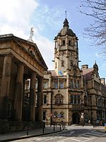
Wakefield County Hall
Wakefield was anciently a market and parish town in the Agbrigg Division of the wapentake of Agbrigg and Morley in the West Riding of Yorkshire. It became a parliamentary borough with one Member of Parliament by the Reform Act 1832. In 1836 the Wakefield Poor Law Union was formed following the Poor Law Amendment Act 1834 with an elected Board of Guardians.[40] The town was incorporated as a municipal borough with elected councillors in 1848 under the Municipal Corporations Act 1835.[41] Wakefield had been the de facto seat of regional government in Yorkshire for two centuries and became the county headquarters of the new West Riding County Council created by the Local Government Act of 1888.[42] After the elevation of Wakefield to diocese in 1888, Wakefield Council immediately sought city status and this was granted in July 1888.[43] Wakefield was made a county borough in 1913.[44] In 1974, under the terms of the Local Government Act 1972, the county borough of Wakefield became defunct as it merged with surrounding authorities to become the City of Wakefield district. Today the city is the headquarters of Wakefield Metropolitan District Council, Local Government Yorkshire and Humber and the West Yorkshire Police.[45][46]
Wakefield is covered by five electoral wards, Wakefield East, Wakefield North, Wakefield Rural, Wakefield South and Wakefield West, of the Wakefield Metropolitan District Council. Each ward elects three councillors to the 63-member metropolitan district council, Wakefield's local authority. As of 2009, nine ward councillors are members of the Conservative Party and six ward councillors are members of the Labour Party who control the council.[47]
Wakefield's MP is Mary Creagh who has represented the parliamentary seat for Wakefield for the Labour Party since the 2005 General Election. From 10 June 2009 until the 2010 election she was an Assistant Whip.[48] She was re-elected in 2010 with a reduced majority.[49]
Sandal,Kettlethorpe, Agbrigg and Belle vue in the South of the city are represented by Labour's Jon Trickett who has been MP for Hemsworth since 1996. He was re-elected in May 2010.[50]
Geography[]
Wakefield is 9 miles (14 km) southeast of Leeds and 28 miles (45 km) southwest of York on the eastern edge of the Pennines in the lower Calder Valley. The city centre is sited on a low hill on the north bank of the River Calder close to a crossing place where it is spanned by a 14th-century, nine arched, stone bridge and a reinforced concrete bridge built in 1929–1930.[51][52] It is at the junction of major north-south routes to Sheffield, Leeds and Doncaster and west-east routes to Huddersfield, Dewsbury and Pontefract.
It is within the area of the Nottinghamshire, Derbyshire & Yorkshire Coalfield and lies on coal measures and sandstones of the Carboniferous period.[53]
Wakefield includes the former outlying villages of Alverthorpe, Thornes, Sandal, Agbrigg, Lupset, Kettlethorpe, Newton Hill and Flanshaw.
| Climate data for Wakefield | |||||||||||||
|---|---|---|---|---|---|---|---|---|---|---|---|---|---|
| Month | Jan | Feb | Mar | Apr | May | Jun | Jul | Aug | Sep | Oct | Nov | Dec | Year |
| Average high °C (°F) | 7 (44) |
7 (44) |
9 (49) |
12 (53) |
16 (60) |
18 (65) |
21 (69) |
21 (69) |
17 (63) |
13 (56) |
9 (49) |
7 (45) |
13.1 (55.5) |
| Average low °C (°F) | 2 (36) |
2 (36) |
3 (37) |
4 (39) |
7 (45) |
10 (50) |
12 (54) |
12 (54) |
10 (50) |
7 (45) |
4 (39) |
3 (37) |
6.4 (43.5) |
| Precipitation mm (inches) | 86.6 (3.41) |
63.5 (2.50) |
67.8 (2.67) |
62.5 (2.46) |
55.6 (2.19) |
66.8 (2.63) |
51.1 (2.01) |
63.5 (2.50) |
64.3 (2.53) |
73.9 (2.91) |
77.7 (3.06) |
91.9 (3.62) |
825.2 (32.49) |
| Source: [54] | |||||||||||||
Neighbouring towns and places[]

|
Morley | Leeds | Castleford |
|
| Ossett | Pontefract | |||
 Wakefield | ||||
| Horbury | Barnsley | Ackworth |
Demography[]
| Wakefield Compared in 2008 | |||
|---|---|---|---|
| 2008 UK Population Estimates[55] | Wakefield | Yorkshire and the Humber | England |
| Total population | 322,300 | 5,213,200 | 51,446,200 |
| White | 95.7% | 90.6% | 88.2% |
| Asian | 2.4% | 5.7% | 5.7% |
| Black | 0.5% | 1.3% | 2.8% |
In 2001 the Wakefield urban area had a population of 76,886[56] comprising 37,477 males and 39,409 females.[56] Also at the time of the 2001 UK census, the City of Wakefield had a total population of 315,172 of whom 161,962 were female and 153,210 were male. Of the 132,212 households in Wakefield, 39.56% were married couples living together, 28.32% were one-person households, 9.38% were co-habiting couples and 9.71% were lone parents. The figures for lone parent households were slightly above the national average of 9.5%, and the percentage of married couples was above the national average of 36.5%; the proportion of one person households was below the national average of 30.1%.[57]
The population density was 9.31 /km2 (24.1 /sq mi). Of those aged 16–74 in Wakefield, 39.14% had no academic qualifications, much higher than 28.9% in all of England. Of Wakefield's residents, 2.53% were born outside the United Kingdom, significantly lower than the national average of 9.2%. The largest minority group was recorded as Asian, at 1.41% of the population.
The number of theft-from-a-vehicle offences and theft of a vehicle per 1,000 of the population was 7.9 and 3.9 compared to the English national average of 6.3 and 2.3 respectively.[58] The number of sexual offences was 0.9, in line with the national average.[58] The national average of violence against another person was 16.7 compared to the Wakefield average of 15.[58] The figures for crime statistics were all recorded during the 2008–09 financial year.
Population change[]
| Population growth in Wakefield from 1881–1961 | |||||||||||
|---|---|---|---|---|---|---|---|---|---|---|---|
| Year | 1881 | 1891 | 1901 | 1911 | 1921 | 1931 | 1939 | 1951 | 1961 | ||
| Population | 22,173 | 23,315 | 24,107 | 43,588 | 52,891 | 59,122 | 56,963 | 60,371 | 61,268 | ||
|
Wakefield RSD 1881 - 1911[59] Wakefield MB/CB 1921 - 1961[60] | |||||||||||
Economy[]
| Wakefield Compared | ||||
|---|---|---|---|---|
| 2001 UK Census | Wakefield | WY Urban Area | England | |
| Population (16-74) | 55,789 | 1,072,276 | 35,532,091 | |
| Full time employment | 39.7% | 39.5% | 40.8% | |
| Part time employment | 12.4% | 12.1% | 11.8% | |
| Self employed | 6.7% | 6.3% | 8.3% | |
| Unemployed | 4.1% | 3.8% | 3.3% | |
| Retired | 14.1% | 12.8% | 13.5% | |
| Source: Office for National Statistics[61] | ||||
The economy of Wakefield changed in the last quarter of the twentieth century, coal mines closed and other traditional manufacturing industries declined contributing to high rates of unemployment. In terms of deprivation, Wakefield, as a whole, is ranked 54th out of 354 Local Authority Districts (1 being the worst). Employment grew by 12% between 1998 and 2003 as the economy recovered and enjoyed growth as the economic base of the district was diversified. Growth has been supported by inward investment from European and United Kingdom government funding which has impacted on the regeneration of the area. Manufacturing still remains an important employment sector although the decline is projected to continue whilst distribution and the service industries are now among the main employers.[62]
At the time of the 2001 Census, there were 33,521 people in employment who were resident within Wakefield. Of these, 20.74% worked in the wholesale and retail trade, including repair of motor vehicles; 14.42% worked within manufacturing industry; 11% worked within the health and social work sector and 6.49% were employed in the transport, storage and communication industries.[63] Wakefield is a member of the Leeds City Region Partnership, a sub-regional economic development partnership covering an area of the historic county of Yorkshire.[64]
Regeneration[]

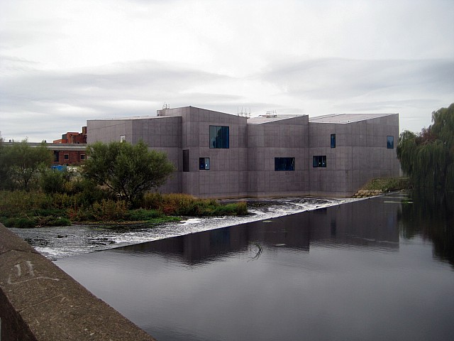
The Hepworth Wakefield and the River Calder
There are number of ongoing regeneration projects in Wakefield including the Trinity Walk development to the north east of the city centre, replacing the market hall and containing retail units and a library.[65] Work began in autumn 2007 but was halted in 2009 and restarted in 2010.[66] The cross roads at the Bull Ring in the city centre has been redesigned and the Ridings Shopping Mall refurbished.[67] Westgate Station goods yard and land on Westgate has been developed to create retail and commercial space including new council offices and a hotel.[68] Developments by the river and canal, the "Wakefield Waterfront", included the refurbishment of the Grade II listed Navigation Warehouse as well as office, retail, restaurant and cafe units. The development also includes The Hepworth Wakefield named in honour of local artist and sculptor, Barbara Hepworth opened in May 2011. It is hoped the gallery will add about £3m to the local economy and attract 150,000 visitors in its first year.[69] Flats and offices are also being built at Chantry Waters, on an island between the river and canal.
Landmarks[]


Chantry Bridge
The most prominent landmark in Wakefield is Wakefield Cathedral, which at 247 feet (75 m) has the tallest church spire in Yorkshire.[70][71] Other landmarks include the Civic Quarter on Wood Street which includes the Neoclassical Wakefield Crown Court of 1810, the Town Hall built in 1880 and the Queen Anne Style County Hall of 1898. St John's Church and Square date from the Georgian period.
The old Wakefield Bridge with its Chantry Chapel and Sandal Castle are ancient Monuments along with Lawe Hill in Clarence Park.[72] Another prominent structure is the 95-arch railway viaduct, constructed of 800,000,000 bricks in the 1860s on the Doncaster to Leeds railway line. At its northern end is a bridge with an 80-foot (24 m) span over Westgate and at its southern end a 163-foot (50 m) iron bridge crossing the River Calder.[73]
Transport[]


The brick built 95 arch viaduct in Wakefield
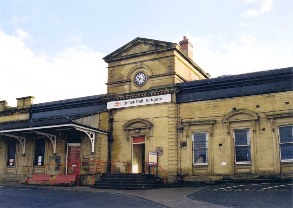

_-wikipedia-.jpg)
Wakefield Kirkgate railway station
Wakefield has good access to the motorway system, the intersection of the M1 and M62 motorways, junctions 42/29, is to the north west and the M1 to the west is accessed at junctions 39, 40 and 41. The A1(M) is to the east of the district. Wakefield is crossed by the A61, A638, and A642 roads and is the starting point of the A636 and A650 roads.
The Council is working with Metro, the other four West Yorkshire district councils and transport operators to provide an integrated transport system for the district through the implementation of the West Yorkshire Local Transport Plan.[74] A network of local buses, coordinated by West Yorkshire Passenger Transport Executive (WYPTE) and departing from the bus station in the town centre, serves Wakefield and district. Buses are operated by Arriva, B L Travel, Poppletons, Stagecoach Yorkshire and National Express.[75]
Wakefield Kirkgate was opened by the Manchester and Leeds Railway in 1840. Wakefield Kirkgate is unmanned and operated by Northern Rail who operate trains to Barnsley, Meadowhall, Sheffield, Normanton, Pontefract, Knottingley, Leeds, Castleford and Nottingham.[76] The station serves the Hallam Line, Huddersfield Line and the Pontefract Line of the MetroTrain network. Grand Central Trains operating between London King's Cross and Bradford Interchange stop at Kirkgate. In 2009 CCTV was installed at the station which has been dubbed the worst in the country. There has been a campaign for the station to be manned after a number of high profile crimes.[77]
Wakefield Westgate opened in 1867 on the Doncaster to Leeds line. It has connections to the East Coast Mainline, trains to Leeds, Doncaster, and stations towards London King's Cross. CrossCountry trains go to Newcastle upon Tyne, Edinburgh, Birmingham and the South West. East Midlands Trains also run trains via Sheffield, Leicester to St Pancras International. Wakefield Westgate is on the Wakefield Line of the MetroTrain network.[78] The line was electrified in 1989. Wakefield is served by inter city express trains, from both its mainline railway stations.
The nearest airport is Leeds Bradford International Airport, 19 miles (31 km) to the north of the city at Yeadon.
The Aire and Calder Navigation is 33 miles (53 km) from Leeds to Goole, and 7.5 miles (12.1 km) from Wakefield to Castleford and was created by Act of Parliament in 1699, it was opened to Leeds in 1704 and to Wakefield in 1706 enabling craft carrying 100 tons to reach Wakefield from the Humber.[3] It is still used by a small amount of commercial traffic and leisure craft.[79] The Calder and Hebble Navigation was created by Act of Parliament in 1758 with the intention of making the Calder navigable to Sowerby Bridge. The route was originally surveyed by John Smeaton remains open and is used by leisure craft.[80] The Barnsley Canal, a broad canal with 20 locks, opened in 1799 connecting Barnsley to the Aire and Calder Navigation at Wakefield and was abandoned in 1953.[81]
Education[]


The original Queen Elizabeth Grammar School building on Brook Street.
Wakefield's oldest surviving school is Queen Elizabeth Grammar School, QEGS Wakefield, a boys' only school established in 1591 by Queen Elizabeth I by Royal Charter. The original building in Brook Street is now known as the 'Elizabethan Gallery'. QEGS moved to Northgate in 1854.[19] The school was administered by the Governors of Wakefield Charities who opened Wakefield Girls High School, WGHS on Wentworth Street in 1878.[82] These two schools today are independent schools. National schools were opened by the Church of England including St Mary's in the 1840s and St John's in 1861.[83] St Austin's R.C. School opened about 1838.[84] A Methodist School was opened in Thornhill Street in 1846.[85] Pinders Primary School, originally Eastmoor School is the only school opened as a result of the Education Act 1870 which remains open today.[86]
Wakefield College has its origins in the School of Art and Craft of 1868[87] and today is the major provider of 6th form and further education in the area, with around 3,000 full-time and 10,000 part-time students,[88] and campuses in the city and surrounding towns. In 2007 Wakefield City Council and Wakefield College announced plans to establish a University Centre of Wakefield but a bid for funding failed in 2009.[89][90] Other schools with sixth forms include: QEGS, Wakefield Girls High School, and Cathedral High School, which is now a Performing Arts College for ages 11 to 18.[91]
Religion[]
| Religion in Wakefield 2001[92] | |||
|---|---|---|---|
| UK Census 2001 | Wakefield | Yorkshire | England |
| Christian | 78.21% | 73.07% | 71.74% |
| No religion | 11.74% | 14.09% | 14.59% |
| Muslim | 1.14% | 3.81% | 3.1% |
| Buddhist | 0.10% | 0.14% | 0.28% |
| Hindu | 0.20% | 0.32% | 1.11% |
| Jewish | 0.04% | 0.23% | 0.52% |
| Sikh | 0.08% | 0.38% | 0.67% |
| Other religions | 0.18% | 0.19% | 0.29% |
| Religion not stated | 7.57% | 7.77% | 7.69% |
Wakefield's oldest church is All Saints, now Wakefield Cathedral, a 14th century parish church built on the site of earlier Saxon and Norman churches, restored by Sir George Gilbert Scott in the 19th century and raised to cathedral status in 1888. The first bishop of Wakefield was William Walsham How. In 1356 the Chantry Chapel of St Mary the Virgin on Wakefield bridge was built originally in wood, and later in stone. This chapel is one of four chantry chapels built around Wakefield and the oldest and most ornate of the four surviving in England.[19][93] Wakefield is also known for the Wakefield Cycle, a collection of 32 mystery plays, dating from the 14th century, which were performed as part of the summertime religious festival of Corpus Christi and revived in recent times.[94]
St John's Church was built in 1795 in the Georgian style. Three new Anglican Commissioners' churches, partly financed by the "Million Fund" were built as chapels of ease in the surrounding districts and were St Peter at Stanley in 1824, St Paul at Alverthorpe in 1825 and St James at Thornes in 1831.[95][96] Holy Trinity in George Street was built in 1838-9.[97] St Andrew's Church opened on Peterson Road in 1846 and St Mary's Church on Charles Street was consecrated in 1864. St Michael's was consecrated in 1861.[98] In the nineteenth century Wesleyan, Primitive and Independent Methodist chapels were opened and the Baptists opened a chapel in George Street in 1844.[99][100]
The Church of England diocese of Wakefield covers parishes mainly in West Yorkshire and partly in South Yorkshire with five parishes in North Yorkshire.[101] The Rt. Revd. Stephen Platten is the 12th Bishop of Wakefield. There are sixteen Church of England churches in the Wakefield deanery.
Wakefield has two Roman Catholic parishes - in the north St. Martin de Porres incorporates the churches of St. Austin's, Wentworth Terrace opened in 1828 and English Martyrs opened in 1932 on Dewsbury Road, Lupset,[102] and in the south, St Peter and St Paul's off Standbridge Lane which has a modern church built in 1991. Wakefield is in the Roman Catholic Diocese of Leeds.[103]
Agbrigg Muslim Association have a Zakaria Masjid Mosque in Wakefield.[104]
Culture[]
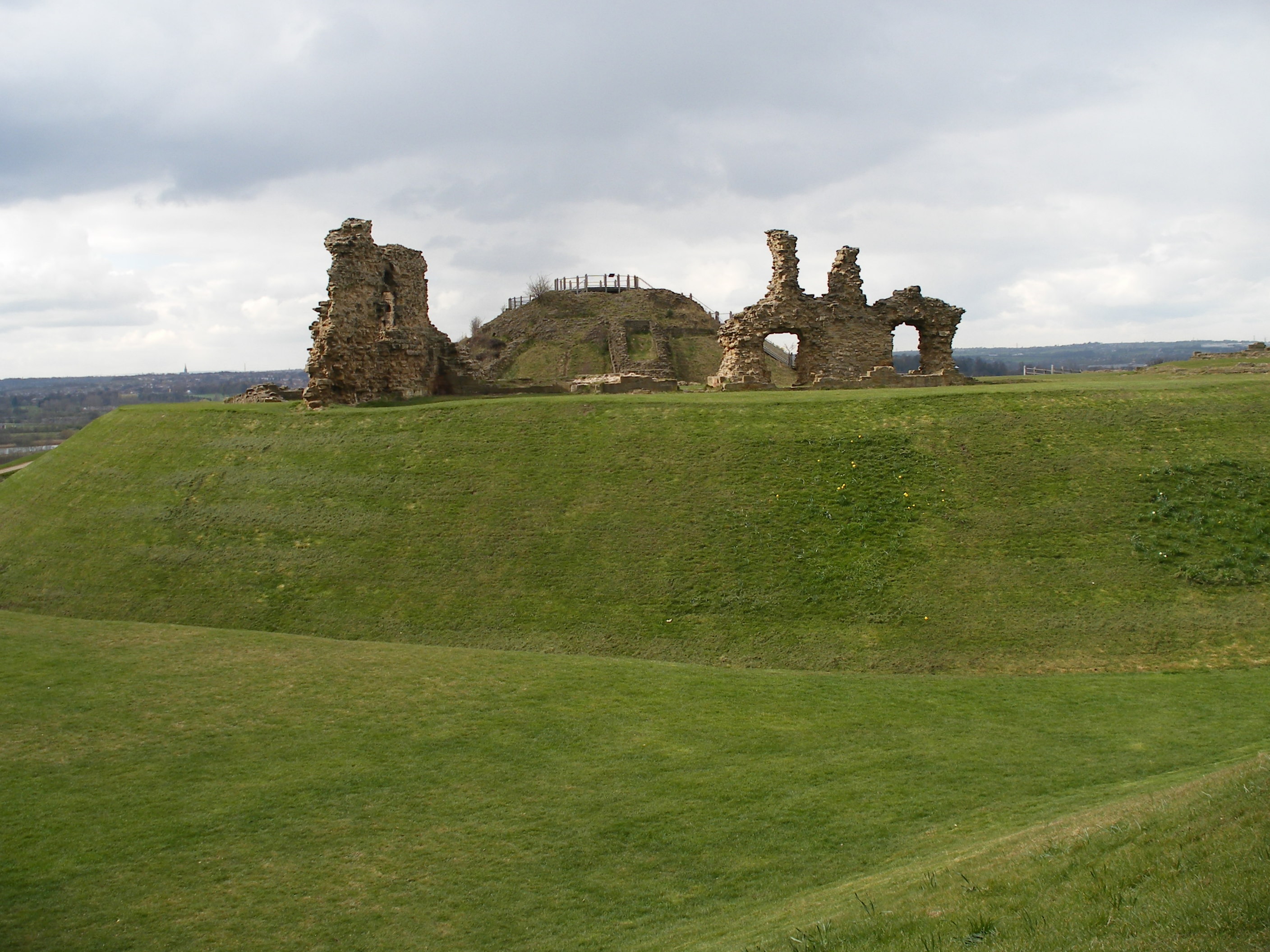

The ruins of Sandal Castle
The ruins of Sandal Castle, with its visitor centre, are open to the public. The Theatre Royal Wakefield on Westgate, designed by architect Frank Matcham opened in 1894 and currently presents a programme of entertainment including musicals, drama, live music, stand up comedy and dance.[105] Wakefield Museum is in the city centre. In May 2011 The Hepworth Wakefield art gallery opened on the south bank of the River Calder near Wakefield Bridge and the chantry chapel, with works by local artists Barbara Hepworth and Henry Moore and other British and international artists. The gallery designed by architect David Chipperfield is thought to be the largest purpose-built gallery to open in the United Kingdom since 1968.[69]
Wakefield Library in Balne Lane manages a regional collection of over 500,000 items of music and 90,000 copies of plays for Yorkshire Libraries & Information (YLI).[106] West Riding Registry of Deeds on Newstead Road is the headquarters of the West Yorkshire Archive Service housing records from the former West Riding and West Yorkshire counties as well as being the record office for the Wakefield Metropolitan District.[107]
Wakefield's three contiguous parks have a history dating back to 1893 when Clarence Park opened on land near Lawe Hill, the adjacent Holmefield Estate was acquired in 1919 followed by Thornes House in 1924 making a large park to the south west of the city.[108] A Music Festival for local bands is held annually in Clarence Park.[109]
Two children's nursery rhymes with Wakefield connections are "Here We Go Round the Mulberry Bush" which may have been sung by women inmates at Wakefield prison.[110] and "The Grand Old Duke of York" which may allude to the Battle of Wakefield in 1460, referring to Richard Plantagenet, the 3rd Duke of York.[111]
Wakefield is known as the capital of the Rhubarb Triangle, an area notable for growing early forced rhubarb. In July 2005 a statue was erected to celebrate this facet of Wakefield which also hosts an annual Rhubarb Festival.[112][113][114]
Wakefield has two newspapers, The Wakefield Express[115] and the Wakefield Guardian,[116] and a radio station, Ridings FM.[117]
The National Coal Mining Museum for England (an Anchor Point of ERIH, The European Route of Industrial Heritage), the Yorkshire Sculpture Park and Nostell Priory[118] are within the metropolitan area as is Walton Hall, a Georgian mansion set in what was the world's first nature reserve, created by the explorer Charles Waterton, now a hotel.
Sport[]
Wakefield Trinity Wildcats is a rugby league club currently playing in the Super League division. The club, founded in 1873, was one of the initial founders of the Northern Union after the split from the Rugby Football Union in 1895. The club plays at Belle Vue.[119] Several local teams play in different leagues of the British Amateur Rugby League Association, BARLA. They include Wakefield City, Westgate Wolves, Crigglestone All Blacks, Kettlethorpe and Eastmoor Dragons.[120]
Rugby Union Football is played at Sandal RFC[121] and was played by Wakefield RFC at College Grove from 1901 to 2004 when the club ceased playing.
Wakefield F.C. play in the Northern Premier League Division One North after moving from the village of Emley in 2001. The club played at Belle Vue until the end of the 2005/6 season when it moved to Wakefield RFC's former ground at College Grove for the 2006/7 season.[122] Wakefield Sports Club at College Grove also has the Yorkshire Regional Hockey Academy, Wakefield Bowls Club and Wakefield Squash Club on the same site.[123]
The Wakefield Archers meet at QEGS in Wakefield or at Slazengers Sports Club, Horbury and has archers shooting Olympic re-curve bows, compound bows and longbows.[124] Thornes Park Athletics Stadium is home to Wakefield Harriers A.C. Members Martyn Bernard and Emily Freeman competed in the Beijing Olympics.[125] Local teams Newton Hill and Wakefield Thornes are members of the Leeds-West Riding Cricket League.[126]
There is a 100-acre (0.40 km2) watersports lake at Pugneys Country Park catering for non-powered watersports such as canoeing, sailing and windsurfing.[127] Golf clubs include the municipal course at Lupset and the private Wakefield Golf Club at Sandal.[128]
Wakefield has two successful current senior international swimmers (Ian Perrell and Rachel Jack). Both former city of Wakefield swimming club members.
Public services[]
Wakefield Prison, originally built as a house of correction in 1594, is a maximum security prison.[129] Wakefield is policed by the West Yorkshire Police force and is within the DA, Wakefield division, which covers the whole district.[130] The statutory emergency fire and rescue service is provided by the West Yorkshire Fire and Rescue Service, from Wakefield fire station.[131] Hospital services are provided by the Mid Yorkshire Hospitals NHS Trust and community health services, including GPs, district and community nurses, dentists and pharmacists, are co-ordinated by Wakefield District Primary Care Trust.[132][133] Waste management is co-ordinated by the local authority. Wakefield's Distribution Network Operator for electricity is CE Electric via Yorkshire Electricity. Yorkshire Water manages Wakefield's drinking and waste water.[134]
Notable people[]
- Henry Shafto Harrison (1810-1892) was born in Wakefield and became M.P for Wanganui in the 1860s after emigrating with his family in 1840.
- Artist and sculptor Barbara Hepworth was born in Wakefield in 1903.[135]
- David Storey born in Wakefield in 1933 is a novelist and playwright who in 1960 wrote "This Sporting Life" which was made into a film in 1963.[136]
- Former Archbishop of York, David Hope, born 1940, The Rt Revd and Rt Hon The Lord Hope of Thornes KCVO PC, was born in Thornes.[137]
Twin cities[]
Wakefield is twinned with several towns and cities including:[138]
 Castres, France
- Hénin-Beaumont, France
- Herne, Germany
- Belgorod, Russia
- Konin, Poland
- Alfeld (Leine), Germany
- Castrop-Rauxel, Germany
See also[]
- The Jolly Pinder of Wakefield
References[]
- Notes
- Footnotes
- ^ Office for National Statistics : Census 2001 : Urban Areas : Table KS01 : Usual Resident Population Retrieved 2009-08-26
- ^ Lupton 1864, p. 46
- ^ a b c d Old Wakefield, oldtowns.co.uk, http://www.oldtowns.co.uk/Yorkshire/wakefield.htm, retrieved 2009-11-21
- ^ Reaney 1964, p. 161
- ^ Mills 1998, p. 361
- ^ Walker 1966, p. 3
- ^ Walker 1966, p. 24
- ^ EarlyHistory, wakefield.gov.uk, http://www.wakefield.gov.uk/CultureAndLeisure/HistoricWakefield/History/default.htm, retrieved 2009-11-16
- ^ Mills 1998, p. 403
- ^ Mills 1998, p. 405
- ^ Walker 1966, p. 43
- ^ Manor, midgleywebpages.com, http://midgleywebpages.com/index-3.html, retrieved 2009-11-16
- ^ "The Yorkshire Archaeological Journal, 1886". Books.google.com. 2007-07-30. http://books.google.com/books?id=vO4GAAAAYAAJ&pg=PA111&lpg=PA111&dq=earl+warenne+wakefield+yorkshire&source=web&ots=zHyItid2qF&sig=NgmkVHSzh4KIkcPFHyx4Re76s9A&hl=en. Retrieved 2011-08-05.
- ^ Butler 1991, p. 1
- ^ Creighton 2004, p. 32
- ^ Holt 1997, p. 19
- ^ "Dodsworth's Yorkshire notes, the wapentake of Agbrigg, Roger Dodsworth, 1884". Books.google.com. 2007-04-20. http://books.google.com/books?id=IrkHAAAAQAAJ&pg=RA1-PA92&lpg=RA1-PA92&dq=lyvet+king&source=web&ots=M8In8xicy-&sig=yHEh-Mt-Z15w6jeWwKiVMie9-Y8&hl=en. Retrieved 2011-08-05.
- ^ Lupton 1864, p. 10
- ^ a b c d 1066–1600, wakefield.gov.uk, http://www.wakefield.gov.uk/CultureAndLeisure/HistoricWakefield/History/1066-1600.htm, retrieved 2009-11-17
- ^ Walker 1966, p. 114
- ^ Walker 1966, p. 414
- ^ Civil War Yorkshire, british-civil-wars.co.uk, http://www.british-civil-wars.co.uk/military/1643-yorkshire.htm, retrieved 2009-11-17
- ^ a b 1600-1800, wakefield.gov.uk, http://www.wakefield.gov.uk/CultureAndLeisure/HistoricWakefield/History/1600-1800.htm, retrieved 2009-11-18
- ^ St Johns Church, St John's Church, http://www.wakefield-stjohns.org.uk/stjohns/St_Johns_Church_History.html, retrieved 2009-11-20
- ^ Taylor 2008, p. 7
- ^ Saunders 1848, p. 102
- ^ Taylor 2008, p. 89
- ^ Taylor 2008, p. 73
- ^ Taylor 2008, p. 92
- ^ a b 1800-1900, wakefield.gov.uk, http://www.wakefield.gov.uk/CultureAndLeisure/HistoricWakefield/History/1800-1900.htm, retrieved 2009-11-20
- ^ Galloway 1971, p. 76
- ^ Taylor 2008, pp. 80,81
- ^ a b Taylor 2008, p. 43
- ^ Taylor 2008, p. 10
- ^ Prison, http://www.wakefield.gov.uk/CultureAndLeisure/HistoricWakefield/Buildings/WakefieldPrison/History/default.htm, retrieved 2009-11-25
- ^ Workhouses, workhouses.org.uk, http://www.workhouses.org.uk/index.html?Wakefield/Wakefield.shtml, retrieved 2009-11-20
- ^ Taylor 2008, p. 60
- ^ Carnegie Library, http://www.wakefield.gov.uk/CultureAndLeisure/Libraries/Services/LocalStudies/CarnegieLibraries/DruryLaneLibrary/1904_1949.htm, retrieved 2009-11-23
- ^ WDH, wdh.co.uk, http://www.wdh.co.uk/QUICKLINKS/AboutUs/Pages/Default.aspx, retrieved 2009-11-21
- ^ Taylor 2008, p. 23
- ^ Taylor 2008, p. 25
- ^ Taylor 2008, p. 41
- ^ Beckett 2005, pp. 39,40
- ^ Freeman 1959, p. 173
- ^ AboutWakefield, wakefield.gov.uk, http://www.wakefield.gov.uk/AboutWakefield/aboutdistrict.htm, retrieved 2009-11-18
- ^ Local Government Yorkshire and Humber, Local Government Yorkshire and Humber, 2009, http://www.lgyh.gov.uk/, retrieved 2009-11-22
- ^ Wards, wakefield.gov.uk, http://www.wakefield.gov.uk/CouncilAndDemocracy/Councillors/Wards/default.htm, retrieved 2009-11-23
- ^ Mary Creagh MP, theyworkforyou.com, http://www.theyworkforyou.com/mp/mary_creagh/wakefield, retrieved 2009-11-22
- ^ Election 2010, BBC, http://news.bbc.co.uk/1/shared/election2010/results/constituency/e84.stm, retrieved 2010-05-09
- ^ "BBC News – Election 2010 – Hemsworth". BBC News. http://news.bbc.co.uk/1/shared/election2010/results/constituency/c13.stm.
- ^ Wakefield Bridge, imagesofengland.org.uk, http://www.imagesofengland.org.uk/Details/Default.aspx?id=444625, retrieved 2009-11-19
- ^ Wakefield New Bridge, engineering-timelines.com, http://www.engineering-timelines.com/scripts/engineeringItem.asp?id=495, retrieved 2009-11-18
- ^ (PDF) Nottinghamshire, Derbyshire & Yorkshire Coalfield Character Area 38, Natural England, http://www.naturalengland.org.uk/Images/jca38tcm2-21137_tcm6-5073.pdf, retrieved 22 November 2009
- ^ Average Weather for Wakefield, ENG - Temperature and Precipitation, Weather.com, http://www.weather.com/outlook/travel/businesstraveler/wxclimatology/monthly/graph/UKXX0152, retrieved 2009-11-22
- ^ "People and Society: Population and Migration: Key Figures: Area: Wakefield (Local Authority)", Neighbourhood Statistics (Office for National Statistics), http://www.neighbourhood.statistics.gov.uk/dissemination/LeadKeyFigures.do?a=7&b=276811&c=Wakefield&d=13&e=13&g=384621&i=1001x1003x1004&m=0&r=1&s=1258709294946&enc=1, retrieved 2009-11-20
- ^ a b KS01 Usual resident population: Census 2001, Key Statistics for urban areas, Office for National Statistics (ONS), 5 August 2004, http://www.statistics.gov.uk/StatBase/ssdataset.asp?vlnk=8271&Pos=2&ColRank=1&Rank=224, retrieved 20 November 2009
- ^ "2001 Census: Key Statistics: Household Composition (KS20): Area: Wakefield (Local Authority)", Neighbourhood Statistics (Office for National Statistics), http://www.neighbourhood.statistics.gov.uk/dissemination/LeadTableView.do?a=7&b=276811&c=Wakefield&d=13&e=15&g=384621&i=1001x1003x1004&m=0&r=1&s=1258712304810&enc=1&dsFamilyId=55, retrieved 2009-11-20
- ^ a b c Crime figures for 2008/09 in Wakefield, UpMyStreet, http://www.upmystreet.com/local/crime-in-wakefield.html, retrieved 2009-11-20
- ^ Wakefield RSD : Total Population, Vision of Britain, http://vision.port.ac.uk/data_cube_page.jsp?data_theme=T_POP&data_cube=N_TOT_POP&u_id=10555140&c_id=10001043&add=N, retrieved 2009-11-25
- ^ Wakefield MB/CB : Total Population, Vision of Britain, http://vision.port.ac.uk/data_cube_page.jsp?data_theme=T_POP&data_cube=N_TOT_POP&u_id=10136313&c_id=10001043&add=N, retrieved 2009-11-25
- ^ KS09a Economic activity - all people: Census 2001, Key Statistics for urban areas, National Statistics, http://www.statistics.gov.uk/StatBase/ssdataset.asp?vlnk=8292&Pos=4&ColRank=1&Rank=240, retrieved 2009-12-13
- ^ Hunter, Phillip (2005) (PDF), Wakefield in Depth 2005, Learning and Skills Council West Yorkshire, p. 12, http://www.wakefield.gov.uk/NR/rdonlyres/AF5093EE-1B21-44F4-AE8E-889C2BBC5236/0/WakefieldInDepth2005.pdf, retrieved 2009-11-17
- ^ KS11a Industry of Employment: Census 2001, Key Statistics for urban areas, National Statistics, http://www.statistics.gov.uk/statbase/ssdataset.asp?vlnk=8306&More=Y, retrieved 2009-12-05
- ^ (PDF) Leeds City Region Development Programme, The City Region Partnership, November 2006, p. 13, http://www.leedscityregion.gov.uk/uploadedFiles/About_Us/M02%20-%20Leeds_CRDP_Nov_2006.pdf?n=2445, retrieved 2009-11-22
- ^ "Work begins on major city centre development", Wakefield Express City (Johnston Press), 2007-09-07, http://www.wakefieldexpress.co.uk/news/Work-begins-on-major-city.3182918.jp, retrieved 2009-11-17
- ^ Marsh Way Area (Trinity Walk), wakefield.gov.uk, http://www.wakefield.gov.uk/Planning/Regeneration/Wakefield/TrinityWalk.htm, retrieved 2009-11-17
- ^ Bull Ring, yorkshire-forward.com, http://www.yorkshire-forward.com/news-events/local-news/bull-ring-refurbishment-begins-in-wakefield, retrieved 2009-11-17
- ^ Westgate, wakefield.gov.uk, http://www.wakefield.gov.uk/Planning/Regeneration/Wakefield/Westgate.htm, retrieved 2009-11-17
- ^ a b New Barbara Hepworth gallery opens in Wakefield, BBC, http://www.bbc.co.uk/news/uk-england-leeds-13483212, retrieved 2011-05-22
- ^ John Bailey. "Wakefield Cathedral, History & Architecture". http://www.wakefieldcathedral.org.uk/History%20&%20Architecture/history.html. Retrieved 2010-09-04.
- ^ "Wakefield Council - Wakefield Cathedral". http://www.wakefield.gov.uk/CultureAndLeisure/HistoricWakefield/Buildings/WakefieldCathedral/default.htm. Retrieved 2010-09-04.
- ^ WakefieldMDC 2008, p. 7
- ^ Walker 1966, p. 558
- ^ (PDF) West Yorkshire Local Transport Plan 2006/07 to 2010/11, West Yorkshire Local Transport Plan Partnership, http://www.wyltp.com/NR/rdonlyres/2CFE302B-5688-4FA8-B952-690CA755EA96/0/060403WYLTPINTRO_pg415.pdf, retrieved 22 November 2009
- ^ Wakefield Bus Station, wymetro.com, http://www.wymetro.com/BusTravel/BusStationsAndStops/WakefieldBusStationStatistics.htm, retrieved 2009-11-20
- ^ Wakefield Kirkgate, nationalrail.co.uk, http://www.nationalrail.co.uk/stations/wkk/details.html, retrieved 2009-12-07
- ^ http://www.yorkshireeveningpost.co.uk/news/Wakefield-Kirkgate-CCTV-for-39worst.5807380.jp
- ^ Wakefield Westgate, nationalrail.co.uk, http://www.nationalrail.co.uk/stations/wkf/details.html, retrieved 2009-12-07
- ^ Aire and Calder Navigation, penninewaterways, http://www.penninewaterways.co.uk/aire/index.htm, retrieved 2009-11-19
- ^ Calder & Hebble, penninewaterways, http://www.penninewaterways.co.uk/calder/index.htm, retrieved 2009-11-20
- ^ Barnsley Canal, penninewaterways, http://www.penninewaterways.co.uk/barnsley/index.htm, retrieved 2009-11-20
- ^ Taylor 2008, p. 125
- ^ Taylor 2008, pp. 129–130
- ^ Taylor 2008, p. 134
- ^ Taylor 2008, p. 131
- ^ Taylor 2008, p. 141
- ^ Taylor 2008, p. 145
- ^ "Wakefield College Information". Wakefield.ac.uk. http://www.wakefield.ac.uk/About/. Retrieved 2011-08-05.
- ^ University of Wakefield plans, Wakefield Express, 2007, http://www.wakefieldexpress.co.uk/news/University-of-Wakefield-plans.3459982.jp, retrieved 2009-11-23
- ^ Wakefield College's funding bid failed, Wakefield Express, 2009, http://www.wakefieldexpress.co.uk/news/Wakefield-College39s-funding-bid-failed.5738789.jp, retrieved 2009-11-23
- ^ www.wakefield.gov.uk: Colleges and universities, Wakefield LEA, 2009, http://www.wakefield.gov.uk/Education/CollegesAndUniversities/default.htm?wbc_purpose=...default.htmdefault.htmdefault.htmdefault.htmdefault.htmdefault.htm%23centrecontent, retrieved 2009-11-23
- ^ "2001 Census: Census Area Statistics: Key Figures: Area: Wakefield (Local Authority)", Neighbourhood Statistics (Office for National Statistics), http://www.neighbourhood.statistics.gov.uk/dissemination/LeadKeyFigures.do?a=7&b=276811&c=Wakefield&d=13&e=16&g=384621&i=1001x1003x1004&m=0&r=1&s=1258711463404&enc=1, retrieved 2009-11-20
- ^ Edward Green, Bridge Chapels, buildingconservation.com, http://www.buildingconservation.com/articles/bridgechapels/bridgechapels.htm, retrieved 2009-11-18
- ^ MysteryPlays, wakefield.gov.uk, http://www.wakefield.gov.uk/CultureAndLeisure/HistoricWakefield/MysteryPlays/default.htm, retrieved 2009-11-21
- ^ Taylor 2008, p. 103
- ^ MillionAct, genuki.org.uk, http://www.genuki.org.uk/big/eng/YKS/Misc/CBW/YPRsMillionAct.html, retrieved 2009-11-25
- ^ Taylor 2008, p. 106
- ^ Taylor 2008, p. 109
- ^ Taylor 2008, pp. 99–103
- ^ Guy Etchells, Church Photographs, rootsweb.ancestry.com, http://freepages.genealogy.rootsweb.ancestry.com/~framland/CHURCH/church.htm, retrieved 2009-11-25
- ^ Wakefield Diocese, Wakefield Diocesan Board of Finance, http://www.wakefield.anglican.org/index.htm, retrieved 2009-11-20
- ^ St Austins, staustins.co.uk, http://www.staustins.co.uk/pnw/, retrieved 2009-11-25
- ^ Welcome to the Diocese of Leeds, Diocese of Leeds, http://www.dioceseofleeds.org.uk/, retrieved 2009-11-20
- ^ Agbrigg Muslim Association Zakaria Masjid, Tijarapages.com, http://www.tijarapages.com/details.asp?bid=1973867286, retrieved 2009-11-20
- ^ theatreroyalwakefield, theatreroyalwakefield.co.uk, http://www.theatreroyalwakefield.co.uk/aboutus/, retrieved 2009-11-20
- ^ Yorkshire Libraries and Information Music and Drama, Wakefield Council, 2009, http://www.wakefield.gov.uk/CultureAndLeisure/Libraries/Services/MusicAndDrama/default.htm, retrieved 2009-11-23
- ^ W Yorks Archives, wyjs.org.uk, http://www.archives.wyjs.org.uk/index.asp?pg=ablocw2.html, retrieved 2009-12-13
- ^ CHaT Parks, chatparks.org, http://www.chatparks.org.uk/index.php?pageid=20, retrieved 2009-11-20
- ^ Clarence Park Music Festival, themusiccollective, http://www.themusiccollective.co.uk/p_People.ikml, retrieved 2009-11-18
- ^ WakefieldPrison, wakefield.gov.uk, http://www.wakefield.gov.uk/CultureAndLeisure/HistoricWakefield/Buildings/WakefieldPrison/default.htm, retrieved 2009-11-18
- ^ The Grand Old Duke of York, rhymes.org., http://www.rhymes.org.uk/the_grand_old_duke_of_york.htm, retrieved 2009-11-18
- ^ Bell 2009, p. 2
- ^ Take a walk in the rhubarb triangle, Wakefield Council, http://www.wakefield.gov.uk/News/PressReleases/news/pr2098.htm, retrieved 2009-11-20
- ^ Rhubarb Festival, wakefield.gov.uk, http://www.wakefield.gov.uk/CultureAndLeisure/RhubarbFestival/default.htm, retrieved 2009-11-20
- ^ Wakefield Express, wakefieldexpress.co.uk, http://www.wakefieldexpress.co.uk/, retrieved 2009-11-22
- ^ Wakefield Guardian, mediauk.com, http://www.mediauk.com/newspapers/343991/wakefield-guardian, retrieved 2009-11-22
- ^ RidingsFM, ridingsfm.co.uk, http://www.ridingsfm.co.uk/, retrieved 2009-11-22
- ^ Nostell Priory, nationaltrust.org, http://www.nationaltrust.org.uk/main/w-nostellpriory, retrieved 2009-11-18
- ^ Wildcats, wakefieldwildcats.co.uk, http://www.wakefieldwildcats.co.uk/wildcats-history-c351.html, retrieved 2009-11-21
- ^ BARLA, barla.org.uk, http://www.barla.org.uk/Clubs/, retrieved 2009-11-21
- ^ Sandal rufc, pitchero.com, http://www.pitchero.com/clubs/sandalrufc/?primary=theclub&secondary=history#_, retrieved 2009-11-21
- ^ Wakefield FC, pitchero.com, http://www.pitchero.com/clubs/wakefieldfc/?primary=theclub&secondary=history, retrieved 2009-11-21
- ^ Wakefield Sports Club, wakefieldsportsclub.co.uk, http://www.wakefieldsportsclub.co.uk/, retrieved 2009-11-21
- ^ The Wakefield Archers, thewakefieldarchers.com, http://www.thewakefieldarchers.com/modules/news/, retrieved 2009-11-21
- ^ Wakefield Harriers AC, wakefield-harriers.co.uk, http://www.wakefield-harriers.co.uk/, retrieved 2009-11-21
- ^ lwrcl, lwrcl.org.uk, http://lwrcl.org.uk/, retrieved 2009-11-21
- ^ Pugneys, wakefield.gov.uk, http://www.wakefield.gov.uk/CultureAndLeisure/ParksAndOpenSpaces/PugneysCountryPark/About.htm, retrieved 2009-11-22
- ^ Golf, wakefield.gov.uk, http://www.wakefield.gov.uk/CultureAndLeisure/LeisureFacilities/GolfCourses/default.htm, retrieved 2009-11-25
- ^ Locate a Prison - Wakefield, HM Prison Service, 2004, http://www.hmprisonservice.gov.uk/prisoninformation/locateaprison/prison.asp?id=477,15,2,15,477,0, retrieved 2009-11-23
- ^ West Yorkshire Police, West Yorkshire Police, http://www.westyorkshire.police.uk/npt/Division.asp?id=15, retrieved 2009-11-22
- ^ Wakefield Fire Station, West Yorkshire Fire and Rescue Service, 2009, http://www.westyorksfire.gov.uk/stations/80_wakefield.htm, retrieved 2009-11-23
- ^ Home.The Mid Yorkshire NHS Trust, The Mid Yorkshire NHS Trust, http://www.midyorks.nhs.uk/, retrieved 2009-11-23
- ^ Our PCT - Wakefield District NHS Primary Care Trust, Wakefield District NHS, http://www.wakefielddistrict.nhs.uk/ourPCT/, retrieved 2009-11-23
- ^ Drainage - sewers, Wakefield Council, http://www.wakefield.gov.uk/Environment/sewers.htm, retrieved 2009-11-23
- ^ Barbara Hepworth, barbarahepworth.org.uk, http://www.barbarahepworth.org.uk/biography/, retrieved 2009-11-25
- ^ David Storey, contemporarywriters.com, http://www.contemporarywriters.com/authors/?p=auth222, retrieved 2009-11-25
- ^ David Hope, bbc.co.uk, http://www.bbc.co.uk/radio4/factual/desertislanddiscs_20051211.shtml, retrieved 2009-11-25
- ^ TownTwinning, wakefield.gov.uk, http://www.wakefield.gov.uk/CommunityAndLiving/TownTwinning/twintowns.htm, retrieved 2009-11-23
- Bibliography
- Beckett, J. V. (2005), City status in the British Isles,1830-2002, Ashgate Publishing, ISBN 0754650677, http://books.google.com/?id=jqqSSOyjBEoC&pg=PA40&dq=wakefield+city+status+1888#v=onepage&q=wakefield%20city%20status%201888
- Bell, Richard (2009), Walks in the Rhubarb Triangle, Willow Island Editions, ISBN 978 1 902467 18 4
- Butler, Lawrence (1991), Sandal Castle Wakefield, Wakefield Historical Publications, ISBN 0 901869 31 7
- Creighton, O. H. (2004), Castles and landscapes, Equinox Publishing Ltd, ISBN 1904768679
- Freeman, T. W. (1966), The Conurbations of Great Britain, Manchester University Press, http://books.google.com/?id=XjS8AAAAIAAJ&pg=PA173&dq=Wakefield+County+Borough&q=Wakefield%20County%20Borough
- Galloway, Robert L. (1971), Annals of Coal Mining and the Coal Trade Vol. 1,1898, David & Charles, ISBN 0 7153 4980 5
- Holt, J.C. (1997), Colonial England, 1066-1215, Continuum International Publishing Group, ISBN 1852851406
- Lupton, Joseph Hirst (1864), Wakefield worthies, biographical sketches, http://books.google.com/?id=VdoHAAAAQAAJ&printsec=frontcover&dq=Wakefield+worthies#v=onepage&q=
- Mills, A. D. (1998), Dictionary of English Place-Names, Oxford, ISBN 0-19-280074-4
- Reaney, P.H. (1964), The origin of English place-names (corrected 3rd pr.), Routledge and Kegan Paul, ISBN 0-19-280074-4
- Saunders, John (1848), The People's journal, Volume 4, John Saunders, http://books.google.com/?id=s1QAAAAAYAAJ&pg=PA102&dq=Wakefield+Corn+Exchange&q=Wakefield%20Corn%20Exchange
- Taylor, Kate (2008), The Making of Wakefield 1801-1900, Wharncliffe, ISBN 978 1 845630 78 2
- WakefieldMDC (2008) (PDF), List of Listed Buildings, Scheduled Ancient Monuments and Buildings of Local Interest, wakefield.gov.uk, http://www.wakefield.gov.uk/NR/rdonlyres/EC7F3485-64A8-4D27-B478-7DB069212F91/0/Listed_Buildings_Nov_2008.pdf
- Walker, J.W. (1966), Wakefield its History and People Vol.1&2 3rd Edn, S.R. Publishers
External links[]
- City of Wakefield Metropolitan District Council
- Wakefield District Development Agency
- Wakefield at the Open Directory Project
| ||||||||||||||
| This page uses content from the English language Wikipedia. The original content was at Wakefield. The list of authors can be seen in the page history. As with this Familypedia wiki, the content of Wikipedia is available under the Creative Commons License. |