| ||||||||||||||
| Wallace County, Kansas | |
 Wallace County courthouse in Sharon Springs
| |
 Location in the state of Kansas | |
 Kansas's location in the U.S. | |
| Founded | 1868 |
|---|---|
| Seat | Sharon Springs |
| Area - Total - Land - Water |
914.05 sq mi (2,367 km²) 913.99 sq mi (2,367 km²) 0.05 sq mi (0 km²), 0.01% |
| Population - (2010) - Density |
1,485 1.6/sq mi (0.6/km²) |
| Time zone | Mountain: UTC-7/-6 |
| Website | WallaceCounty.net |

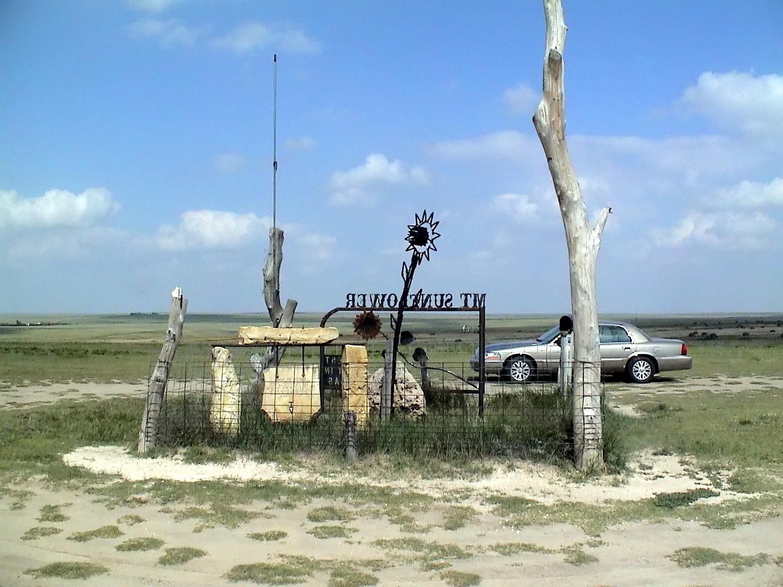
"Mount Sunflower," the highest point in Kansas, is located in Wallace County
Wallace County (standard abbreviation: WA) is a county located in the U.S. state of Kansas. As of the 2010 census, the county population was 1,485.[1] It has the second lowest population of any county in Kansas. Greeley County, which borders on the south, has the lowest. Its county seat is Sharon Springs.[2] It was created in 1868 and named in honor of Brigadier general W.H.L. Wallace who was a veteran of the Mexican-American War and a casualty of the Battle of Shiloh.
Wallace County is home to Mount Sunflower, the highest point in Kansas at 4,039 feet (1,231 meters). Mount Sunflower is located approximately 15 miles (24 km) north-northwest of Weskan, less than one mile (1.6 km) from the Colorado state line.
Law and government[]
Although the Kansas Constitution was amended in 1986 to allow the sale of alcoholic liquor by the individual drink with the approval of voters, Wallace County has remained a prohibition, or "dry", county.[3]
Geography[]
According to the 2000 census, the county has a total area of 914.05 square miles (2,367.4 km2), of which 913.99 square miles (2,367.2 km2) (or 99.99%) is land and 0.05 square miles (0.13 km2) (or 0.01%) is water.[4]
Adjacent counties[]
- Sherman County (north)
- Logan County (east)
- Wichita County (southeast)
- Greeley County (south)
- Cheyenne County, Colorado (west)
- Kit Carson County, Colorado (northwest)
Demographics[]
| Historical populations | |||
|---|---|---|---|
| Census | Pop. | %± | |
| 1900 | 1,178 | ||
| 1910 | 2,759 | 134.2% | |
| 1920 | 2,424 | −12.1% | |
| 1930 | 2,882 | 18.9% | |
| 1940 | 2,216 | −23.1% | |
| 1950 | 2,508 | 13.2% | |
| 1960 | 2,069 | −17.5% | |
| 1970 | 2,215 | 7.1% | |
| 1980 | 2,045 | −7.7% | |
| 1990 | 1,821 | −11.0% | |
| 2000 | 1,749 | −4.0% | |
| 2010 | 1,485 | −15.1% | |

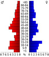
Age pyramid
As of the census[5] of 2000, there were 1,749 people, 674 households, and 477 families residing in the county. The population density was 2 people per square mile (1/km²). There were 791 housing units at an average density of 1 per square mile (0/km²). The racial makeup of the county was 94.63% White, 0.63% Black or African American, 0.80% Native American, 0.17% Asian, 2.52% from other races, and 1.26% from two or more races. 4.80% of the population were Hispanic or Latino of any race.
There were 674 households out of which 33.80% had children under the age of 18 living with them, 63.60% were married couples living together, 4.00% had a female householder with no husband present, and 29.20% were non-families. 27.60% of all households were made up of individuals and 13.60% had someone living alone who was 65 years of age or older. The average household size was 2.56 and the average family size was 3.12.
In the county the population was spread out with 29.10% under the age of 18, 6.50% from 18 to 24, 23.60% from 25 to 44, 22.80% from 45 to 64, and 18.10% who were 65 years of age or older. The median age was 40 years. For every 100 females there were 99.00 males. For every 100 females age 18 and over, there were 99.40 males.
The median income for a household in the county was $33,000, and the median income for a family was $42,022. Males had a median income of $25,610 versus $18,333 for females. The per capita income for the county was $17,016. About 10.70% of families and 16.10% of the population were below the poverty line, including 24.50% of those under age 18 and 12.70% of those age 65 or over.
Cities and towns[]
Incorporated cities[]
Name and population (2010 census):
- Sharon Springs, 748 (county seat)
- Wallace, 57
Townships[]
Wallace County is divided into four townships. None of the cities within the county are considered governmentally independent, and all figures for the townships include those of the cities. In the following table, the population center is the largest city (or cities) included in that township's population total, if it is of a significant size.
| Township | FIPS | Population center |
Population | Population density /km² (/sq mi) |
Land area km² (sq mi) |
Water area km² (sq mi) |
Water % | Geographic coordinates |
|---|---|---|---|---|---|---|---|---|
| Harrison | 30450 | 85 | 0 (1) | 210 (81) | 0 (0) | 0% | ||
| Sharon Springs | 64400 | Sharon Springs | 1,096 | 1 (3) | 885 (342) | 0 (0) | 0% | |
| Wallace | 74775 | 175 | 0 (1) | 488 (188) | 0 (0) | 0.01% | ||
| Weskan | 76700 | Wallace | 393 | 1 (1) | 784 (303) | 0 (0) | 0.01% |
Education[]
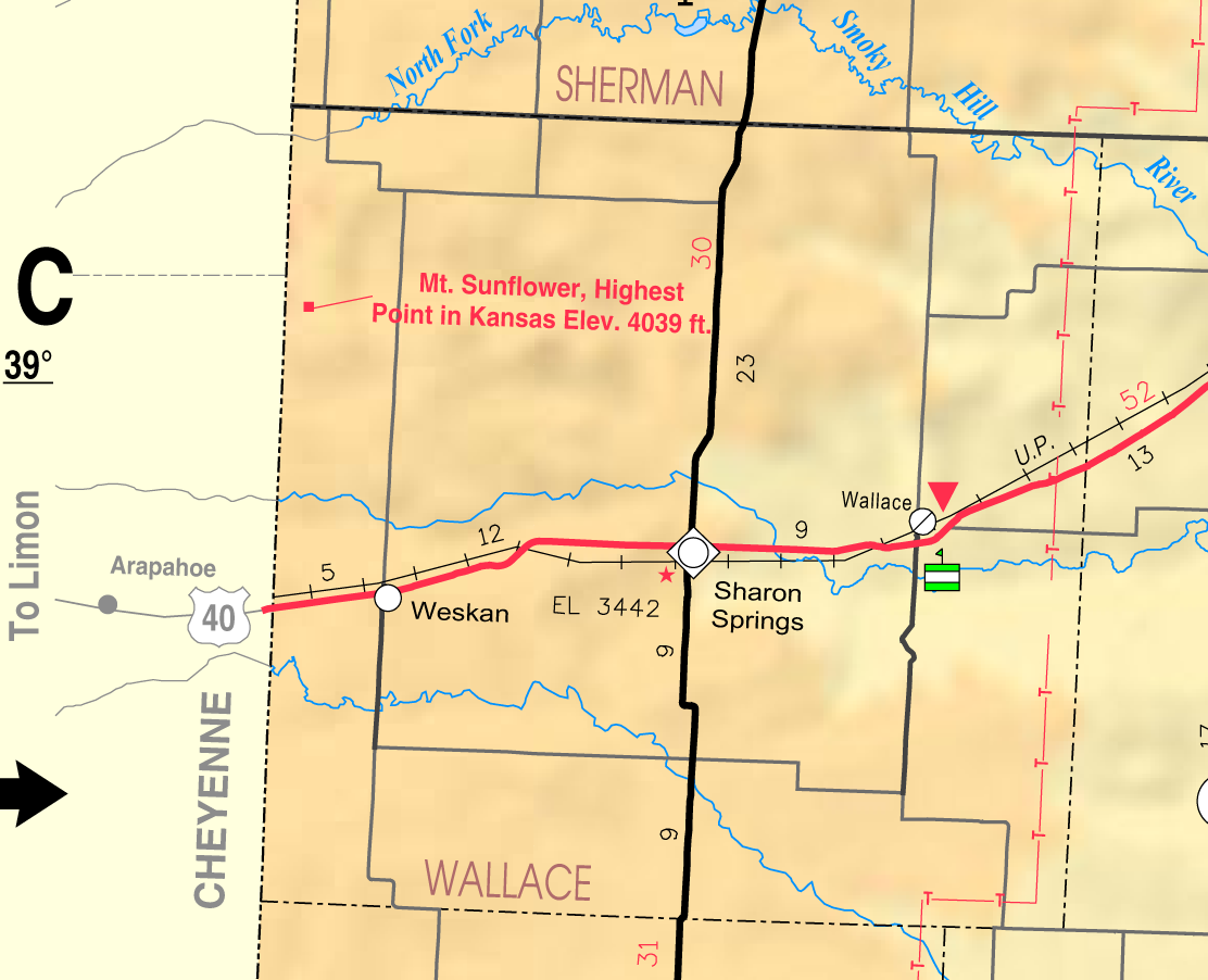
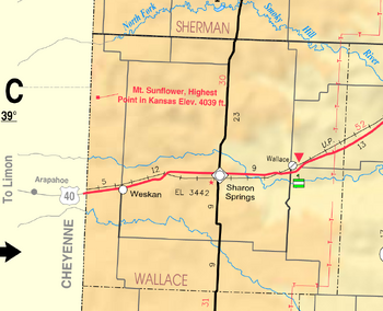
Map of Wallace County from KDOT (map legend)
Unified school districts[]
See also[]
Information on this and other counties in Kansas
- List of counties in Kansas
- List of Kansas county name etymologies
- National Register of Historic Places listings in Kansas
- Kansas locations by per capita income
Other information for Kansas
- List of cities in Kansas
- List of unified school districts in Kansas
- List of colleges and universities in Kansas
References[]
- ^ "2010 County Population and Housing Occupancy Status". U.S. Census Bureau. http://factfinder2.census.gov/faces/tableservices/jsf/pages/productview.xhtml?pid=DEC_10_PL_GCTPL2.ST05&prodType=table. Retrieved March 28, 2011.
- ^ "Find a County". National Association of Counties. http://www.naco.org/Counties/Pages/FindACounty.aspx. Retrieved 2011-06-07.
- ^ "Map of Wet and Dry Counties". Alcoholic Beverage Control, Kansas Department of Revenue. November 2004. http://www.ksrevenue.org/abcwetdrymap.htm. Retrieved 2007-01-21.
- ^ "Census 2000 U.S. Gazetteer Files: Counties". United States Census. http://www.census.gov/tiger/tms/gazetteer/county2k.txt. Retrieved 2011-02-13.
- ^ "American FactFinder". United States Census Bureau. http://factfinder.census.gov. Retrieved 2008-01-31.
Further reading[]
- History of the State of Kansas; William G. Cutler; A.T. Andreas Publisher; 1883. (Online HTML eBook)
- Kansas : A Cyclopedia of State History, Embracing Events, Institutions, Industries, Counties, Cities, Towns, Prominent Persons, Etc; 3 Volumes; Frank W. Blackmar; Standard Publishing Co; 944 / 955 / 824 pages; 1912. (Volume1 - Download 54MB PDF eBook),(Volume2 - Download 53MB PDF eBook), (Volume3 - Download 33MB PDF eBook)
External links[]
- Official
- General Information
- Maps
- Wallace County Map, KDOT
- Kansas Highway Map, KDOT
- Kansas Railroad Map, KDOT
- Kansas School District Boundary Map, KSDE

|
Kit Carson County, Colorado | Sherman County |
| |
| Cheyenne County, Colorado | Logan County | |||
 Wallace County, Kansas | ||||
| Greeley County | Wichita County |
| |||||
| This page uses content from the English language Wikipedia. The original content was at Wallace County, Kansas. The list of authors can be seen in the page history. As with this Familypedia wiki, the content of Wikipedia is available under the Creative Commons License. |