| Main | Births etc |
|---|
| Wick | |
| Scottish Gaelic: Inbhir Ùige | |
| Scots: Week | |
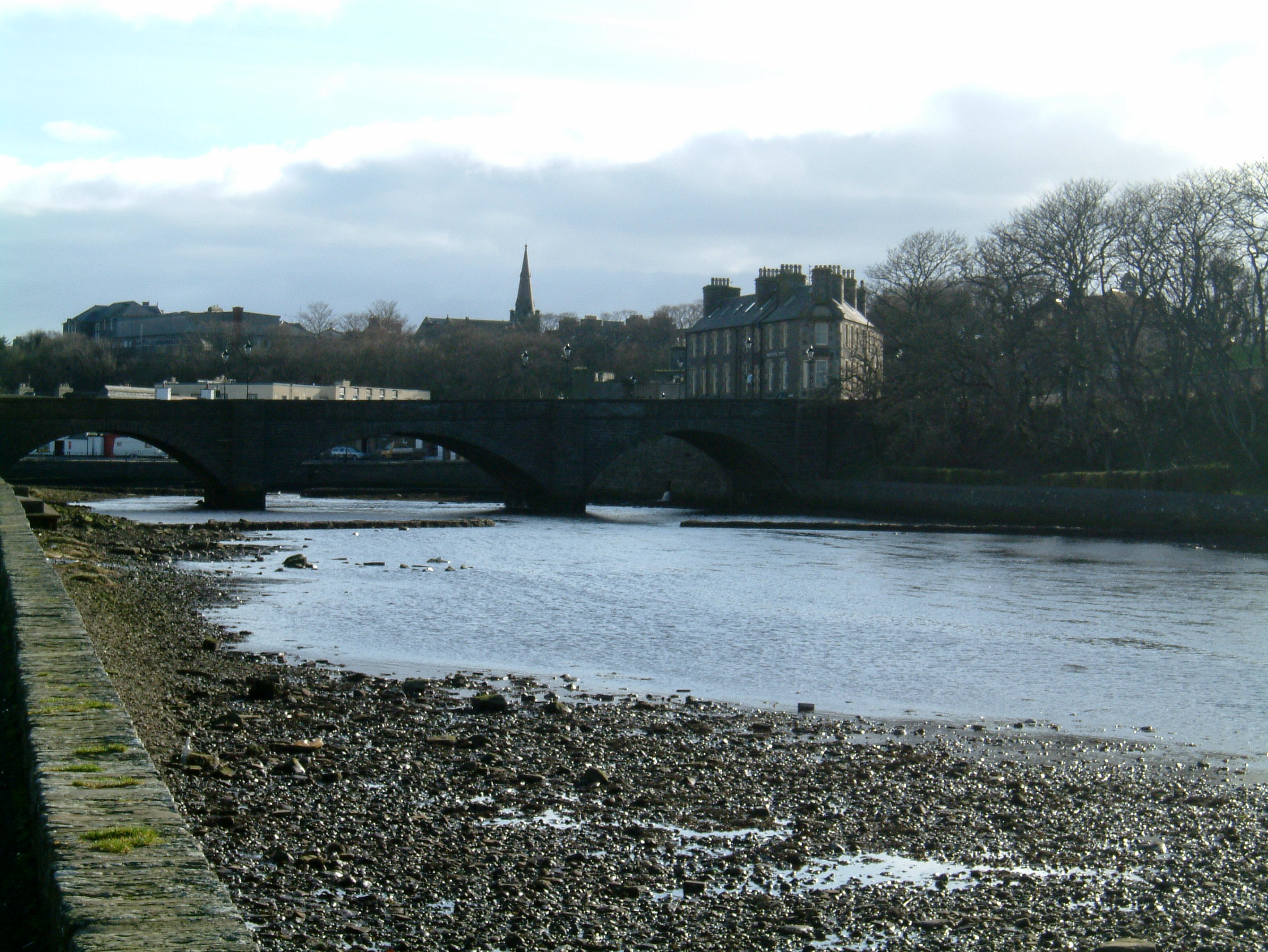 Looking down-river towards the Bridge of Wick |
|

Wick | |
| Area | |
|---|---|
| Population | 7,333 Census 2001 |
| - Density | |
| OS grid reference | |
| - Edinburgh | 172 mi (277 km) |
| - London | 493 mi (793 km) |
| Council area | Highland |
| Lieutenancy area | Caithness |
| Country | Scotland |
| Sovereign state | United Kingdom |
| Post town | WICK |
| Postcode district | KW1 |
| Dialling code | 01955 |
| Police | Northern |
| Fire | Highlands and Islands |
| Ambulance | Scottish |
| EU Parliament | Scotland |
| UK Parliament | Caithness, Sutherland and Easter Ross |
| Scottish Parliament | Caithness, Sutherland and Ross |
| List of places: UK • Scotland • | |
Wick (Scottish Gaelic: Inbhir Ùige, Scots: Week[2]) is a town and royal burgh in Caithness, in the far north of Scotland. The town straddles the River Wick and extends along both sides of Wick Bay. Wick Locality had a population of 6,954 at the time of the 2011 census, a decrease of 3.8% from 2001.[3][4]
Pulteneytown, which was developed on the south side of the river by the British Fisheries Society during the 19th century,[5] was officially merged into the burgh in 1902.
The town is on the main road (the A99–A9 road) linking John o' Groats with southern Britain. The Far North railway line links Wick railway station with southern Scotland and with Thurso, the other burgh of Caithness. Wick Airport is on Wick's northern outskirts. The airport has two usable runways. A third is derelict.[6]
The main offices of The John O'Groat Journal and The Caithness Courier are located in Wick, as are Caithness General Hospital (run by NHS Highland), the Wick Carnegie Library and local offices of the Highland Council. Wick Sheriff Court is one of 16 sheriff courts serving the sheriffdom of Grampian, Highland and Islands.
History[]
Pre-Christian Wick[]
Iron Age activity in the parish of Wick[7] is evident in the hill fort at Garrywhin. Evidence of activity around Wick from the Norse pagan period was discovered in 1837 when brooches and bracelets from the Norse were uncovered by archaeologists.[8] The name Wick appears to be from a Norse word, vík, meaning bay,[9] cf. also the word viking.
Conversion to Christianity[]
In the eighth century, Saint Fergus, an Irish missionary, lived in Wick or its immediate vicinity during his mission to the people in the area. He is the patron saint of Wick. One of the fairs in Wick, the Fergusmas, is named for this saint.[10] It is believed that the Chapel of St. Tear in Wick Parish near Ackergill was founded in the eighth century by St Drostan, whose ministry was in Aberdeenshire.[11]
12th and 13th centuries[]


Castle of Old Wick
Wick belonged to Norway, as did all of Caithness, until the reign of William the Lion (1165-1214), at which time the Norwegian earls held of the king of Scotland.[12]
The Castle of Old Wick, commonly known as “The Old Man of Wick” (or “Aul man o’ Wick”) is thought to have been built in about 1160 by Harald Maddadson, Earl of Caithness and Orkney. Earl Harald, who was half Norse, is thought to have resided there. It was long used by fishermen as an aid to navigation in the North Sea.
The Origines Parochiales Scotiae records these events for twelfth-century Wick:
Between the years 1142 and 1149 Rognvald Earl of Orkney went into Katanes and was there entertained at Vik by a husbandman named Sveinn the son of Hroald, a very brave man. When Sveinn Asleifson was in the Hebrides, he committed the keeping of Dungulsbae, which he had received from Earl Rognvald, to Margad Grimson, whose oppressions caused many to take refuge with Hroald in Wik. This occasioned a dispute between Hroald and Margad, and the latter soon afterwards went to Wik with nineteen men and slew Hroald. Between the years 1153 and 1156, Harald Maddadson, then joint Earl Katanes and Orkney with Earl Rognvald, passed into Katanes and wintered at Wik.[13]
14th and 15th centuries[]
In about 1330, the parish of Wick was included among the Caithness lands owned by the family of Cheyne. The last male heir, Sir Reginald de Cheyne, died c. 1345 and was succeeded by his two daughters, who, by marriage, carried the lands into the clans Sinclair, Sutherland, and Keith.[14]
Between 1390 and 1406, King Robert III granted the town of Wick in heritage to Neill Sutherland with a burgh of barony.[15]
In 1438, the clans Gunn and Keith joined battle near Wick on the moor of Tannach with both sides suffering heavy losses. However, hostilities between the two clans were not ended at that time.[16]
16th century[]
In 1503, the Parliament of Scotland established a sheriff for Caithness, who “should sit and have a place for administration of his office within the town of Wick.”[17]
In 1538, Ackergill Tower, three miles north of Wick, was granted to William Keith, 4th Earl Marischal and Lady Margaret Keith, his wife. Nine years later, George, Earl of Caithness, and others seized the tower house, taking hostage Alexander Keith, captain of the castle, and John Scarlet, his servitor, who were imprisoned in Girnigoe, Braal Castle, and other places. They were charged with treason but were granted remission by Queen Mary.[18]
In 1583, when George Sinclair, 4th Earl of Caithness, died at Edinburgh, his heart was brought to Wick where it was encased in lead and placed in Sinclair's aisle at the church of Wick.[19] However, it entered the story of Wick once again in 1588 when Wick suffered at the hands of Alexander Gordon, 12th Earl of Sutherland, in his campaign against the 5th Sinclair Earl of Caithness, who had killed his kinsman. While Sinclair and his men concealed themselves in Girnigoe Castle nearby, Sutherland proceeded to burn the town of Wick, “an achievement of no great difficulty, as the place at that time merely consisted of a few mean straggling houses thatched with straw.” All structures in the town except the church were burned. During the chaos of the fire, a Highlander intent on plundering the church broke open the lead case which contained the heart of the late Earl of Caithness, and, disappointed that no treasure was in the casque, flung the heart into the wind.[20]
In 1589, James VI made the town into a royal burgh in favour of the fifth Earl of Caithness.[21]
17th century[]
Wick did not escape the turbulence of the Reformation period when, in 1613, the Anglican archdeacon Richard Merchiston of Bower, a graduate of the University of Edinburgh, was brought into Caithness by Bishop Patrick Forbes. Merchiston, a zealous iconoclast, angered the Catholic townspeople when he broke up the stone sculpture of St. Fergus, the town's patron saint. At first yielding to the city authorities who tried to prevent violence, a band of men nevertheless followed the parson as he returned home in the evening, took him by force, and drowned him in the Wick River. When questioned about the murder, they alleged that it had been the work of the saint himself, whom they claimed they had seen astride Merchiston, holding his head below the water.[22]
In 1680, the last clan battle in Scotland took place two miles west of Wick at Altimarlach, involving a dispute between Campbell of Glenorcy and the Sinclairs over the earldom of Caithness. The Sinclairs headquartered in Wick, where they became the victims of a cunning stratagem by an agent of Glenorchy, who ordered that a ship loaded with whisky, “the nectar of Caithness,” come to ground nearby, presuming the Sinclairs would imbibe the drink in quantity. He was not wrong. The next morning, weakened by their revels of the night before, the Sinclairs marched out to meet the Campbells and were ambushed at Altimarlach. Nearly all the Sinclairs were driven into the river and drowned.[23]
18th century[]
In the eighteenth century, the people of Wick were Gaelic-speakers, but according to a presbytery report of 1707, they could understand English.[24]
When Robert Forbes, appointed episcopal Bishop of Caithness in 1762, arrived in the county, he discovered there was no minister at Wick, but he is known to have held services and performed confirmations at the “house of Mr. Campbell” there.[25]
In the year of his arrival, Bishop Forbes reported that every year on the morning of the Feast of Innocents Day (December 28), the people of Wick and its environs would gather for prayer at the ruins of the Chapel of St. Tear near Noss Head. In ruins at the time, the chapel had originally been made of stone and mortar without any lime, leaving little gaps in the wall into which people would press offerings of bread, cheese, and money. He left this description of the event:
In the afternoon, they get music—a piper and fiddler—and dance on the green where the chapel stands. The roof is off, but the walls are almost entire. One of the late Presbyterian preachers of Wick thought to have abolished this old practice; and for that end appointed a Diet of catechising in that corner of the parish upon the day of the Holy Innocents, but not one attended him; all went, as usual, to St. Tear’s Chapel. I saw the font-stone for baptism lying on the green at the east end of the chapel. Mr. Sutherland, of Wester, observed that no doubt it has been called the Chapel of St. Tear from the tears of the parents and other relations of the murdered innocents.[26]
The Rev. Charles Thomson, a nineteenth-century minister of the Free Church of Wick, stated in the New Statistical Account of Scotland that, though the bread and cheese were intended for the souls of the slain children, a dog-keeper in the neighbourhood would take the food out and feed it to the hounds.[27]
19th century[]
In the late eighteenth century, the British Fishery Society had established fishing ports at Tobermory (1787) and Ullapool (1788), but when shoals of herring normally plentiful in the area moved away from the west coast, authorities turned toward Wick as a good prospect for the herring industry. Construction of Wick Harbour began in 1803 and was completed by 1811. It soon became a bustling harbour with ships from the Isles, the coast of Scotland, Wales, Shetland, and the Isle of Man.[28] With the rise in fisheries, the size of the town increased, and Wick replaced Thurso as the centre of both shipping and trade in Caithness.[29]
In 1800 a bridge was built at Wick, before which travellers from the south could only cross over into Wick via a footbridge of eleven pillars connected by planks. (Calder 32) In 1803 the Highland Roads Act allowed that the “Parliamentary” road which ran from Inverness to Thurso be extended from the Ord to Wick and then to Thurso, construction of which was completed in 1811. (C&S 67) In 1818, the mail coach, which was already running between Inverness and Tain, extended its reach by passing Bonar Bridge and the Ord to Wick and Thurso, which offered better communication between Wick and the south of Scotland.[30]
In 1806, Wick Baptist Church was founded, first meeting in a small loft in Kirk Lane, and later moving into a newly built Church in Union Street in 1865.[31]
Pulteneytown was founded in 1808 to provide space for the many Scots displaced by the Highland Clearances, who poured to the coast in search of work in the fishing industry.[32]
Two newspapers were established in Wick in the nineteenth century: the John o’ Groat Journal in 1836 and the Northern Ensign in 1850, both of which are said to have espoused Liberal views in politics.[33]
In 1868, Robert Louis Stevenson stayed in Wick while his uncle, Alan Stevenson, a lighthouse engineer, was overseeing the construction of Noss Head Lighthouse, which opened in 1869.[34]
20th century[]
Captain Ernest Edmund "Ted" Fresson, OBE, doing business as Highland Airways Limited, established the first air service at Wick, using a grass field one nautical mile north of town. On 8 May 1933 Fresson's company began its first scheduled service between Inverness, Wick, and Kirkwall.[35]
In 1939, the field was put under the authority of the Air Ministry and turned into an RAF base. The field was improved with hard runways, hangars, and other buildings, and became one of fourteen airfields ranging from Iceland to North Yorkshire administered by No. 18 Group, RAF Coastal Command, whose headquarters was at Pitreavie, Fife.[36]
Pilots flying from Wick engaged in reconnaissance, anti-submarine patrols, convoy escort, defence of Scapa Flow, and strikes against the Germans in Norway and Norwegian waters. The plane most frequently used was the Lockheed Hudson.[37]
In May 1940, Wick came under frequent air attack after the defeat of the Netherlands and Denmark and the occupation of Norway left Wick more vulnerable, and their defence of Scapa Flow and the harbour area made them a target. It is stated that 222 high explosives were dropped on Caithness, and that Wick proper was attacked six times. The first and most serious bombing was on 1 July 1940, when a bomb fell on Bank Row during daytime hours when children were playing outside, the first daytime bombing in the UK. Fifteen people were killed, eight of them children.[38]
Historic descriptions of Wick[]
In 1726, a writer described the town of Wick this way:[39]
The burgh of Wick, a small toun of little trade, lyes on the east end of the church and north side of the water, where it runs into the sea, and before it, is a bay formed more than a mile in breadth between the Head of Wick on the north and the Head of Old Wick on the south with a harbour at the end of the toun to which ships of between 20 and 30 last burden can come in safely. There is a bridge at the toun of Wick for the convenience of the parish of eleven pillars built with loose stones and only timber laid over them. They are maintained by the south side of the parish for carrying them to the church, the water being broad there by the swelling of the tide.
In 1868, Scottish author Robert Louis Stevenson stayed in Wick while his uncle, Alan Stevenson, a lighthouse engineer, was overseeing the construction of Noss Head Lighthouse, which opened in 1869. He wrote a letter to his mother describing the town:[40][41]
Wick lies at the end or elbow of an open triangular bay, hemmed on either side by shores, either cliff or steep earth-bank, of no great height. The grey houses of Pulteney extend along the southerly shore almost to the cape; and it is about half-way down this shore — no, six-sevenths way down — that the new breakwater extends athwart the bay.
Certainly Wick in itself possesses no beauty: bare, grey shores, grim grey houses, grim grey sea; not even the gleam of red tiles; not even the greenness of a tree. The southerly heights, when I came here, were black with people, fishers waiting on wind and night. Now all the S.Y.S. (Stornoway boats) have beaten out of the bay, and the Wick men stay indoors or wrangle on the quays with dissatisfied fish-curers, knee-high in brine, mud, and herring refuse. The day when the boats put out to go home to the Hebrides, the girl here told me there was ‘a black wind’; and on going out, I found the epithet as justifiable as it was picturesque. A cold, BLACK southerly wind, with occasional rising showers of rain; it was a fine sight to see the boats beat out a-teeth of it.
In Wick I have never heard any one greet his neighbour with the usual ‘Fine day’ or ‘Good morning.’ Both come shaking their heads, and both say, ‘Breezy, breezy!’ And such is the atrocious quality of the climate, that the remark is almost invariably justified by the fact. The streets are full of the Highland fishers, lubberly, stupid, inconceivably lazy and heavy to move. You bruise against them, tumble over them, elbow them against the wall — all to no purpose; they will not budge; and you are forced to leave the pavement every step.
To the south, however, is as fine a piece of coast scenery as I ever saw. Great black chasms, huge black cliffs, rugged and over- hung gullies, natural arches, and deep green pools below them, almost too deep to let you see the gleam of sand among the darker weed: there are deep caves too. In one of these lives a tribe of gipsies. The men are ALWAYS drunk, simply and truthfully always. From morning to evening the great villainous-looking fellows are either sleeping off the last debauch, or hulking about the cove ‘in the horrors.’ The cave is deep, high, and airy, and might be made comfortable enough. But they just live among heaped boulders, damp with continual droppings from above, with no more furniture than two or three tin pans, a truss of rotten straw, and a few ragged cloaks. In winter the surf bursts into the mouth and often forces them to abandon it.
Geography[]
Wick River[]


Bridge of Wick
The town lies on the estuary of the Wick River, spanned by two road bridges. The Harbour Bridge spans the river at its mouth, to link Wick town centre with Wick Harbour and Pulteneytown. It stands instead of the earlier Service Bridge. Further upstream the Bridge of Wick carries the main road linking John o' Groats with Latheron and Inverness (the A99-A9).
Pulteneytown[]


River Basin, Wick (1980)
Pulteney town is now an area of Wick on the south side of the River Wick. Until 1902 Pulteney town was administered separately from the Royal Burgh of Wick.[42]
Pulteney town takes its name from Sir William Pulteney, a governor of the British Fisheries Society, who also commissioned Robert Adam to build the Pulteney Bridge in Bath. In the early years of the 19th century Sir William commissioned Britain's leading civil engineer, Thomas Telford, to design and supervise the creation of a major new herring fishing town and harbour at the estuary of the River Wick.[43]
Pulteneytown was so named after the death of Sir William in 1805 and became a major player in the 19th century herring boom. It was built in order to supply work to the Gaels evicted during the Highland Clearances.[44] During this boom period the harbour was expanded still further by local shipbuilder James Bremner. History of this era is preserved in the collections of Wick Heritage Museum.[45]
As created by the British Fisheries Society, Pulteneytown consisted of Lower Pulteney and Upper Pulteney. Lower Pulteney was primarily a working area, built on a sandbank behind the harbour. Upper Pulteney was primarily a residential area, on higher ground.
Pulteneytown Parish Church (of the Church of Scotland) is located in Argyle Square and was opened in 1842. Additional hall accommodation has been added and the main church completely renovated to a very high standard for the needs of a twenty-first century congregation. Services are held twice every Sunday.
The Old Pulteney whisky distillery is in the Pulteneytown area. The first Caithness Glass factory was also in this area,[46] but Caithness Glass has now left both the town and Caithness.
Wick Bay[]
Wick Bay is an isosceles triangle with the river mouth as its apex, and the points of South Head and North Head, separated by about one kilometre, as the base of the triangle. Beyond the heads lies the North Sea. Pentland Firth line about 11 kilometres north of North Head.

_-_geograph.org.uk_-_863118.jpg)
There are three harbours in Wick, the Outer Harbour, the Inner Harbour, and the River Harbour, all of which are formed and protected by breakwaters. The Outer and Inner Harbours are on the south side of the estuary, divided from the River Harbour by a breakwater. The River Harbour straddles the river, with breakwaters on either side of an entrance about 30 m (98 ft) wide.[47]
Wick Inner Harbour now has an extensive marina complex, and is fast becoming a base for leisure boating. It is also now a well known stopping point for visiting pleasure craft.[48]
In 2012 a storm battered the harbor, causing extensive damage.[49] In June 2016, another storm smashed a hole in the seawall.[50]
Map references[]
Historical[51] and current maps of Wick are available online.[52]
| Latitude and longitude | Ordnance Survey grid reference | |
|---|---|---|
| North Head | ND383508 | |
| South Head | ND377497 | |
| Wick Harbour | ND368505 |
Climate[]
Wick has an oceanic climate (Köppen Cfb), encompassing a narrow temperature range, low sunshine levels and high winds. Despite its far north location, close to the path of Atlantic depressions, rainfall averages below 800 mm (31 in) due to a rain shadow caused by mountains to the west.
| Climate data for Wick (WIC), elevation: 36 m or 118 ft, 1981–2010 normals, extremes 1930–present | |||||||||||||
|---|---|---|---|---|---|---|---|---|---|---|---|---|---|
| Month | Jan | Feb | Mar | Apr | May | Jun | Jul | Aug | Sep | Oct | Nov | Dec | Year |
| Record high °C (°F) | 13.0 (55.4) |
15.3 (59.5) |
19.9 (67.8) |
20.2 (68.4) |
22.0 (71.6) |
24.4 (75.9) |
25.6 (78.1) |
25.6 (78.1) |
23.9 (75.0) |
19.7 (67.5) |
16.7 (62.1) |
14.1 (57.4) |
25.6 (78.1) |
| Average high °C (°F) | 6.2 (43.2) |
6.4 (43.5) |
7.8 (46.0) |
9.6 (49.3) |
11.8 (53.2) |
14.0 (57.2) |
16.0 (60.8) |
16.2 (61.2) |
14.4 (57.9) |
11.6 (52.9) |
8.6 (47.5) |
6.6 (43.9) |
10.8 (51.4) |
| Daily mean °C (°F) | 3.7 (38.7) |
3.8 (38.8) |
4.9 (40.8) |
6.6 (43.9) |
8.6 (47.5) |
11.0 (51.8) |
13.0 (55.4) |
13.2 (55.8) |
11.5 (52.7) |
9.0 (48.2) |
6.1 (43.0) |
4.0 (39.2) |
7.9 (46.2) |
| Average low °C (°F) | 1.2 (34.2) |
1.1 (34.0) |
2.0 (35.6) |
3.5 (38.3) |
5.4 (41.7) |
7.9 (46.2) |
10.0 (50.0) |
10.1 (50.2) |
8.5 (47.3) |
6.3 (43.3) |
3.5 (38.3) |
1.4 (34.5) |
5.1 (41.2) |
| Record low °C (°F) | −11.1 (12.0) |
−13.9 (7.0) |
−10.5 (13.1) |
−7.1 (19.2) |
−3.9 (25.0) |
−1.1 (30.0) |
1.6 (34.9) |
0.5 (32.9) |
−2 (28.4) |
−6.1 (21.0) |
−10.8 (12.6) |
−11.7 (10.9) |
−13.9 (7.0) |
| Precipitation mm (inches) | 72.3 (2.846) |
63.7 (2.508) |
66.5 (2.618) |
49.9 (1.965) |
48.6 (1.913) |
53.4 (2.102) |
61.5 (2.421) |
64.6 (2.543) |
73.7 (2.902) |
94.9 (3.736) |
90.1 (3.547) |
75.2 (2.961) |
814.3 (32.059) |
| Avg. precipitation days (≥ 1.0 mm) | 16.1 | 13.5 | 15.6 | 11.7 | 11.2 | 10.3 | 11.9 | 12.7 | 13.7 | 16.5 | 16.9 | 15.6 | 165.7 |
| Mean monthly sunshine hours | 48.0 | 70.7 | 110.8 | 138.1 | 189.1 | 152.9 | 136.2 | 134.9 | 116.2 | 92.3 | 54.9 | 35.7 | 1,279.6 |
| Source #1: Met Office[53] | |||||||||||||
| Source #2: KNMI[54] | |||||||||||||
Governance[]
Wick has history as a royal burgh dating from 1589.[55]
In 1975, under the Local Government (Scotland) Act 1973, the local government burgh was merged into the Caithness district of the two-tier Highland region.[56]
In 1996, under the Local Government etc (Scotland) Act 1994, the district was abolished and the region became a unitary council area.[57]
From 1996 until 2007, the town of Wick was covered by two or three wards, each electing one councillor by the first past the post system of election. This year, a single Wick ward was created to elect three councillors by the single transferable vote system. The new ward is one of three within the Highland Council's Caithness ward management area and one of seven within the council's Caithness, Sutherland and Easter Ross corporate management area.[58]
There is also the Royal Burgh of Wick Community Council,[59] which was created in 1977, after the local government burgh had been abolished in 1975. The community council is not a tier of local government but it is recognised as a level of statutory representation. The community council represents an area which is much smaller than that represented by ward councillors, and the ward area also includes parts of other community council areas.
Wick is within the former civil parish of Wick. The parish has that of Latheron to the south, those of Watten and Bower to the west, and that of Canisbay to the north. The eastern boundary of the parish is Moray Firth coastline.[60]
Parliamentary representation[]
Wick was a parliamentary burgh, combined with Dingwall, Dornoch, Kirkwall and Tain in the Northern Burghs constituency of the House of Commons of the Parliament of Great Britain from 1708 to 1801 and of the Parliament of the United Kingdom from 1801 to 1918. Cromarty was added to the list in 1832.[61]
The constituency was a district of burghs known also as Tain Burghs until 1832, and then as Wick Burghs. It was represented by one Member of Parliament.[61] In 1918 the constituency was abolished and the Wick component was merged into the then new county constituency of Caithness and Sutherland.
Economy[]
Caithness Glass[]
A specialist glass manufacturer was established in Wick in 1961. Production was progressively moved to Perth between 1979 and 2004. Manufacturing in Wick thus ceased and the physical connection with Caithness was severed. Caithness Glass manufactured the trophy for the BBC Mastermind television quiz programme.
Old Pulteney Distillery[]
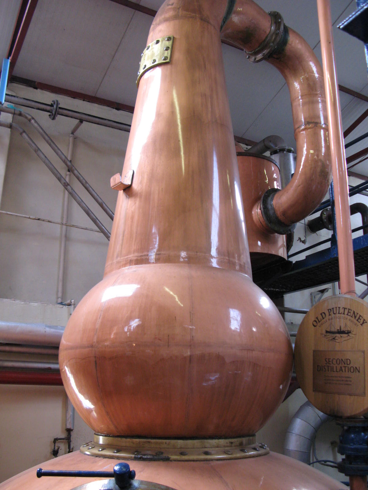

Pot still in Pulteney Distillery
The Old Pulteney Distillery is an aging malt whisky production facility in Pulteneytown. The distillery has a visitor centre in Huddart Street, and produces the Old Pulteney Single Malt whisky at a number of ages.[62] Its 21-year-old single malt was named World Whisky of the Year by leading expert Jim Murray in his 2012 Whisky Bible.[63]
Like Pulteneytown the distillery is named for Sir William Pulteney, 5th Baronet. The distillery was established in 1826 when Pulteneytown was quite newly established as a herring fishing port.[43] The distillery is the most northerly on the Scottish mainland and was quite inaccessible, when established, except by sea. Barley was brought in by sea, and the whisky was shipped out the same way. At that time many of the distillery workers were also fishermen. Old Pulteney is promoted as a Highland single malt Scotch.
The distillery is now owned by Inver House Distillers Limited, a subsidiary of Thai Beverages. Other Inver House distilleries include the Speyburn-Glenlivet Distillery, Knockdhu Distillery, Balblair Distillery and Balmenach Distillery.
Ignis Wick Ltd[]
Ignis Wick Ltd operates the district heating scheme in Wick, and provides heat and hot water via underground insulated pipes to nearly 200 homes from a central boiler house. Formerly known as Caithness Heat and Power Limited (CHaP) it was owned by the Highland Council. Operations are based at the Old Pulteney distillery in Wick.
The council initiated the scheme, with origins evident in minutes of the 16 December 2002 meeting of the council's Caithness committee. It was planned, originally, as a biomass-fuelled combined heat and power scheme, producing mains grid electricity as well as heat. The CHaP company was formed on 7 July 2005,[64] as a non-profit company with three directors, representing the council, the Pulteneytown People's Project charity, and the distillery owners.
The biomass gasification plant failed to work as intended, however, and what had been planned as temporary use of fossil-oil plant became a longer term arrangement. CHaP incurred significant financial losses of more than £13 million. Therefore, in 2008, the council had no real option except to take full, direct control of the company and, by February 2009, the council had to accept that the original biomass plant did not work economically.[65][66]
Ignis Biomass Ltd took over the district heating scheme in 2012, and has installed a renewable energy biomass plant to replace the fossil-oil plant.[67] As of 2013, the scheme supplies heat to the distillery and to nearly 200 homes, and Ignis plans to extend the heat supply to more homes.
Landmarks[]
Castle of Old Wick[]
The Castle of Old Wick () was built in the 12th century when the Norwegian earldom of Orkney included Caithness, and was united under Harald Maddadsson.[68] The castle is thought to have been his stronghold on the mainland of Britain. There is evidence that the site was occupied before the present castle was built.
All that remains today is a tall tower sitting on the very edge of the cliffs, about half a mile south of Wick Bay and of the modern town of Wick, but originally the castle had at least 4 stories as well as extra buildings containing workshops and other quarters.
During the 14th century it was owned by Sir Reginald de Cheyne who was a supporter of Edward I during his attempt to establish John Balliol as King of Scotland, although there is no evidence of a battle having taken place there. It was abandoned in the 18th century. [69] The castle was built to the same plan as Brough Castle, which is about 29 kilometres to the north/northwest, on the Pentland Firth coast of Caithness.
Heritage Museum[]
Wick Heritage Museum is in Bank Row, Pulteneytown. The museum is run by the Wick Society, with a strong focus on the herring-boom era of Wick's history. The herring trade relied on the export of cured herring to the Continent (in particular, Stettin and St Petersburg) and languished after the First World War.[70] The Johnston Collection,[71] which was gathered by the local photographer's business between 1863 and 1975 provides a fascinating insight into the history of the town and the industry.
Carnegie Library[]

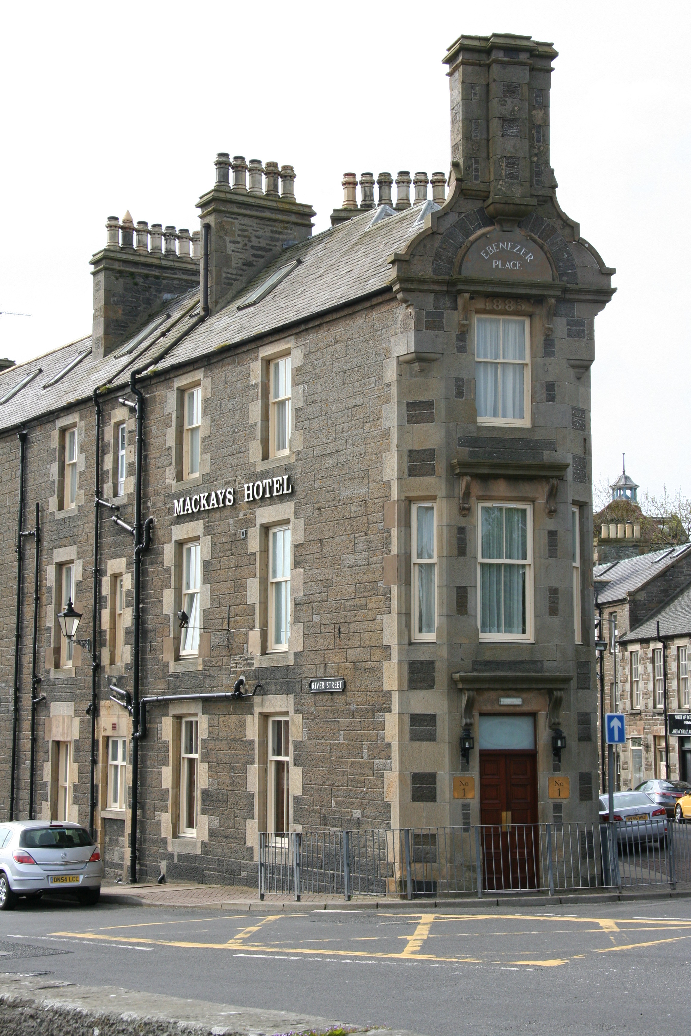
Ebenezer Place, Wick
The Wick Carnegie Library is now run by the Highland Council. As well as providing a general library service the library preserves valuable books and other documents about Wick and Caithness and their histories. Also it preserves a crocodile (Gavialis gangeticus) presented by Sir Arthur Bignold in 1909.[72]
The library building also houses the North Highland Archive and the St. Fergus Gallery exhibitions. The North Highland Archive is part of the Highland Council Archive Service, and holds collections of official and private papers, the earliest dating from 1589, relating to Wick and the county of Caithness.[73] Construction of the library building, 1897, was part funded by Andrew Carnegie. It is at the junction of Sinclair Terrace and Cliff Road.
The Caithness county archives were transferred from Wick library to Nucleus, the Nuclear and Caithness Archives near Wick Airport in February 2017.[74]
Tourist Information Centre[]
The Tourist Information Centre is now located upstairs in the Mcallan's store on High Street.
World's shortest street[]
In 2006 the BBC reported that the Guinness Book of Records had confirmed the world's shortest street, Ebenezer Place measuring 2.06 metres, and containing just one door, was located in Wick (ND363508). It had not previously qualified for the record because it did not have a full postal address.[75]
Education[]
There are two primary schools in Wick, both run by the Highland Council. They are Noss Primary School and Newton Park Primary School. There is one secondary school in Wick, Wick High School. There were previously four primary schools in Wick, these being North Primary, Hillhead Primary (both merged to make Noss Primary), South Primary and Pultneytown Academy (both merged to make Newton Park Primary).[76][77][78]
Hillhead's head teacher is Ally Budge. As of January 2008, it had an enrolment of 205 pupils.[79] Hillhead has been awarded an Eco-Schools First Green Flag award for Environmental friendliness. In April 2008, Hillhead Primary was praised in a report from Her Majesty's Inspectorate of Education.[80]
In September 2008, Wick High School underwent a successful inspection by Her Majesty's Inspectorate of Education.[81] At the time of the report, there was an enrolment of 838, and the rector was Alistair Traill.
In December 2012 Highland Council announced it had signed a contract for the construction of a £48.5m campus that will replace a number of facilities: the high school, swimming pool, library, and two primary schools, South and Pulteneytown (merging into Newton Park Primary).[82] In April 2016 a new primary school, Noss Primary, opened. It merged the two primary schools - Hillhead and North School together.
Sports[]
- Wick Academy F.C. play in the Highland Football League.
- Wick Golf Club
On Film[]
There is surviving black and white and colour film footage of Wick and the Highlands in the National Library of Scotland.[83] The 1967 children's film The Hunch, set in Wick,[84] can be watched online for free.
Twin towns[]
For twenty years the town was twinned with Klaksvík, Faroe Islands. In August 2015, Wick councillors threatened to break these ties on account of a Faroese long standing practice which involves hunting and eating migrating pilot whales.[85] As of January 2016 the decision has been deferred.[86]
Notable people[]
- William Barclay, theologian, born 5 December 1907, Wick, died 24 January 1978
- John Barneson, businessman, born 1 January 1862, Wick, died 26 February 1941
- James Bremner (25 September 1784 – August 1856) a notable Scottish naval architect, harbour builder and ship-raiser.
- Dr Donald Finlayson FRSE MC (1889-1975) research chemist
- Henry Horne, 1st Baron Horne
- Charlotte McShane, a Scottish born Australian triathlete
- Evan Oliphant, cyclist
- Alexander Henry Rhind, Egyptologist, 1833–1863
Notes and references[]
- ^ Wick boundaries those of the Highland Council ward and Caithness boundaries those of the Highland Council wards management area
- ^ Eagle, Andy. "The Online Scots Dictionary". http://www.scots-online.org/dictionary/read.asp?letter=W&CurPage=14.
- ^ "POPULATION CHANGE IN CAITHNESS AND SUTHERLAND 2001 TO 2011", The Highland Council. 11 February 2014. Retrieved 10 January 2017
- ^ General Register Office for Scotland map showing boundaries of Wick Locality, accessed 12 March 2010 Archived 7 March 2012 at the Wayback Machine
- ^ Jean Dunlop The British Fisheries Society 1786–1893 (Edinburgh,1978) p.154
- ^ See Google Maps at coordinates given opposite the title.
- ^ Thomson, Charles (1845). The new statistical account of Scotland. Edinburgh and London: W. Blackwood and Sons. pp. 117–177. https://archive.org/stream/newstatisticala01clergoog#page/n370/mode/2up/. Retrieved 24 November 2017.
- ^ Campbell, H. F. (1920). Caithness and Sutherland. Cambridge: Cambridge UP. p. 60. https://archive.org/stream/caithnesssutherl00campuoft#page/60/mode/2up. Retrieved 5 February 2017.
- ^ "History of Wick Harbour - A Brief History". http://www.wickharbour.co.uk/history.htm.
- ^ Campbell. Caithness. p. 35.
- ^ Myatt, Leslie J.. "St Drostan in Caithness". http://www.caithness.org/history/articles/saintdrostan.htm. Retrieved 5 February 2017.
- ^ Low, Sidney J.; Pulling, F. S. (1910). The Dictionary of English History. London: Cassel. p. 217. https://books.google.com/books?id=4cYJAAAAIAAJ&pg=PA217&dq=norway+caithness+scotland+1231&hl=en&sa=X&ved=0ahUKEwjnv5GMwfrRAhVH-mMKHXZlBnwQ6AEINjAF#v=onepage&q=norway%20caithness%20scotland%201231&f=false. Retrieved 5 February 2017.
- ^ Origines Parochiales Scotiae. Edinburgh. 1855. p. 2:777. https://books.google.com/books?id=G-U9AQAAMAAJ&pg=PA777&lpg=PA777&dq=Between+the+years+1142+and+1149+Rognvald+earl+of+Orkney+went+into+Katanes+and+was+there+entertained+at+Vik+by+a+husbandman+named+Sveinn&source=bl&ots=TeT1tSs3yy&sig=H1gPNseYqbmTrqJsWIIW4WmZq18&hl=en&sa=X&ved=0ahUKEwjYxqTOyfrRAhUBEGMKHVNVDAsQ6AEIHDAA#v=onepage&q=Between%20the%20years%201142%20and%201149%20Rognvald%20earl%20of%20Orkney%20went%20into%20Katanes%20and%20was%20there%20entertained%20at%20Vik%20by%20a%20husbandman%20named%20Sveinn&f=false. Retrieved 5 February 2017.
- ^ Lewis, Samuel (1851). A Topographical Dictionary of Scotland (2nd ed.). London. p. 2:603. https://books.google.com/books?id=AthEAQAAMAAJ&pg=PA603&dq=Wick+Caithness+1350&hl=en&sa=X&ved=0ahUKEwizyYL-wfXRAhWd8oMKHR4JBIwQ6AEIJzAD#v=onepage&q=Wick%20Caithness%201350&f=false. Retrieved 6 February 2017.
- ^ Origines. p. 2:773.
- ^ "Sketch of the Civil and Traditional History of Caithness from the Tenth Century". http://www.electricscotland.com/history/caithness/chapter5.htm. Retrieved 6 February 2017.
- ^ Scots Revised Reports: Court of Session. First Series, Vol. 2. Edinburgh: Green. 1900. p. 6:552. https://books.google.com/books?id=3xhHAQAAMAAJ&pg=PA552&lpg=PA552&dq=1503+courts+wick+caithness&source=bl&ots=Kct9gQMSY-&sig=yrZpyXCFc6wYKxKzevgV15GUgqg&hl=en&sa=X&ved=0ahUKEwjX056GyvXRAhUl5YMKHVL2AEcQ6AEILjAD#v=onepage&q=1503%20courts%20wick%20caithness&f=false. Retrieved 6 February 2017.
- ^ Originales. 778-79.
- ^ Mackay, Robert (1829). History of the House and Clan of Mackay. Edinburgh. p. 147. https://books.google.com/books?id=7KVVAAAAcAAJ&pg=PA81&dq=wick+caithness+1450&hl=en&sa=X&ved=0ahUKEwju4ZmjyPXRAhUp0YMKHbjjCWIQ6AEIRjAJ#v=onepage&q=wick&f=false. Retrieved 6 February 2017.
- ^ Calder, J. T.. "History of Caithness". http://caithness.org/history/historyofcaithness/chapter8/index.htm. Retrieved 6 February 2017.
- ^ Originales. p. 777.
- ^ Craven, James Brown (1908). A History of the Episcopal Church in the Diocese of Caithness. Kirkwall: Peace. p. 59. https://books.google.com/books?id=U1YLAAAAYAAJ&pg=PA59&lpg=PA59&dq=richard+merchiston+of+bower&source=bl&ots=FwkGPSrtD-&sig=hdLKy7T5kViD63bWH8lwkreYUV8&hl=en&sa=X&ved=0ahUKEwj7luOR_PbRAhVPHGMKHY5uBGsQ6AEIHDAA#v=onepage&q=richard%20merchiston%20of%20bower&f=false. Retrieved 6 February 2017.
- ^ Calder. History. pp. 184–88.
- ^ Morrison, Donald. "Census Study Shows Caithness's Gaelic Past". BBC. https://www.bbc.com/news/uk-scotland-highlands-islands-17515935. Retrieved 6 February 2017.
- ^ Craven. History of the Episcopal Church. p. 124.
- ^ Craven. History of the Episcopal Church.
- ^ (September 1880) "Notes on Caithness History". The Celtic Magazine 5 (59). Retrieved on 6 February 2017.
- ^ "The Rise and Fall of the Herring Fishery". http://www.angusmacleodarchive.org.uk/view/index.php?path=%2F8.+The+Fishing+Industry+in+Lewis+and+Scotland%2F1.+Background+and+Overview%2F3.+The+Rise+and+Fall+of+the+Herring+Fishery.pdf. Retrieved 6 February 2017.
- ^ Campbell. Caithness. pp. 44–45.
- ^ Campbell. Caithness. p. 68.
- ^ "Wick Baptist Church - Wick, Highland - Places of Worship in Scotland – SCHR". scottishchurches.org.uk. http://www.scottishchurches.org.uk/sites/site/id/8445/name/Wick+Baptist+Church+Wick+Highland. Retrieved 2017-08-29.
- ^ "Appendix: A New Vision for Wick". http://www.gov.scot/Resource/0042/00425984.pdf. Retrieved 6 February 2017.
- ^ Calder. History. p. 32.
- ^ Campbell. Caithness. p. 29.
- ^ "Captain Ted Fresson". http://www.undiscoveredscotland.co.uk/usbiography/f/tedfresson.html. Retrieved 6 February 2017.
- ^ Myers, P. R.. "Air Operations RAF Wick Part One - September 1939 - December 1940". http://www.caithness.org/history/articles/airoperationsrafwickpart1/airoperationsrafwickpartone.htm. Retrieved 6 February 2017.
- ^ "Wings over Wick". http://www.caithness.org/wings/. Retrieved 6 February 2017.
- ^ "The Bank Row Bombing". http://www.caithness.org/history/bankrowbombing/index.htm. Retrieved 6 February 2017.
- ^ Anderson, William (1855). Origines Parochiales Scotiae: pt. 1. Diocese of Argyle. Diocese of the Isles. Edinburgh. p. 2:778. https://books.google.com/books?id=737lAAAAMAAJ&pg=PA778&lpg=PA778&dq=%22The+burgh+of+Wick,+a+small+toun+of+little+trade,+lyes+on+the+east+end+of+the+church%22&source=bl&ots=6B9b7UfXWi&sig=t0pfCJZ1Cy3JUCX37ljP-0qPwd0&hl=en&sa=X&ved=0ahUKEwiT0feNvffRAhVU8mMKHXWlCg8Q6AEIGjAA#v=onepage&q=%22The%20burgh%20of%20Wick%2C%20a%20small%20toun%20of%20little%20trade%2C%20lyes%20on%20the%20east%20end%20of%20the%20church%22&f=false. Retrieved 4 February 2017.
- ^ Campbell, H. F. (1920). Caithness and Sutherland. Cambridge: Cambridge UP. p. 29. https://archive.org/stream/caithnesssutherl00campuoft#page/28/mode/2up/search/noss+head. Retrieved 4 February 2017.
- ^ Stevenson, Robert Louis. "The Letters of Robert Louis Stevenson". University of Adelaide. https://ebooks.adelaide.edu.au/s/stevenson/robert_louis/s848l/complete.html. Retrieved 4 February 2017.
- ^ "Appendix: A New Vision for Wick". http://www.gov.scot/Resource/0042/00425984.pdf. Retrieved 7 August 2016.
- ^ a b "Sir William Johnstone Pulteney and The Scottish Origins of Western New York". The Crooked Lake Review. Summer 2004. http://www.crookedlakereview.com/articles/101_135/132summer2004/132johnstone.html.
- ^ "BBC - History - British History in depth: The Cultural Impact of the Highland Clearances". http://www.bbc.co.uk/history/british/civil_war_revolution/scotland_clearances_01.shtml.
- ^ https://wickheritage.org/
- ^ "Appendix"
- ^ Cruising Association Handbook (7th ed.). The Cruising Association. p. 130.
- ^ "Wick Marina". Wick Harbour Authority. 2009-09-24. http://www.wickharbour.co.uk/marina.htm.
- ^ "Counting the cost after freak storm hits Wick", Caithness Courier. December 12, 2012. Retrieved 10 jan 2017
- ^ "Storm takes rising toll on Wick harbour wall", Caithness Courier. June 1, 2016. Retrieved 10 jan 2017
- ^ "OS town plans 1847-1895". Ordnance Survey. http://maps.nls.uk/geo/find/#zoom=15&lat=58.4395&lon=-3.0890&layers=9&b=1&point=58.4435,-3.0841. Retrieved 12 October 2017.
- ^ "OS 25 inch map 1892-1949, with Bing opacity slider". Ordnance Survey. http://maps.nls.uk/geo/explore/#zoom=15&lat=58.4403&lon=-3.0791&layers=168&b=1. Retrieved 12 October 2017.
- ^ "Wick 1981–2010 averages". Met Office. http://www.metoffice.gov.uk/public/weather/climate/gfmu99nxj. Retrieved 10 September 2017.
- ^ "Wick extreme values". KNMI. http://eca.knmi.nl/indicesextremes/customquerytimeseriesplots.php. Retrieved 10 September 2017.
- ^ "Wick (Surveyed in 1872)". http://maps.nls.uk/townplans/background/wick.html. Retrieved 7 August 2016.
- ^ Local Government (Scotland) Act 1973
- ^ Local Government etc (Scotland) Act 1994, Office of Public Sector Information website, accessed 8 March 2010
- ^ "Map showing Highland Council wards and corporate management areas, Highland Council website, accessed 21 February 2011". Archived from the original on 31 December 2010. https://web.archive.org/web/20101231152943/http://www.highland.gov.uk/NR/rdonlyres/7B5BC937-CC01-460A-A5FA-ABF63EEBD9C7/0/newwardmap.pdf.
- ^ "Wick Community Council - Home". http://www.spanglefish.com/WickCommunityCouncil/.
- ^ "Parish of Wick". http://www.scottish-people.info/parishes/parhistory116.html. Retrieved 7 August 2016.
- ^ a b The Encyclopædia Britannica: A Dictionary of Arts, Sciences, and General Literature. Philadelphia: Somerville. p. 24:588. https://books.google.com/books?id=_GlJAAAAYAAJ&pg=PA588&lpg=PA588&dq=wick+burghs+1832+one+member+parliament&source=bl&ots=-cFf2UzLTi&sig=BNYL6ZxqfeDg0ZQzo8udhg_mzFA&hl=en&sa=X&ved=0ahUKEwjBtantxLDOAhVDLyYKHVLACY0Q6AEIPTAF#v=onepage&q=wick%20burghs%201832%20one%20member%20parliament&f=false. Retrieved 7 August 2016.
- ^ "Old Pulteney". Inver House Distillers Limited. 2009-09-24. http://www.oldpulteney.com.
- ^ "Wick malt named world's best whisky". BBC News. 23 October 2011. https://www.bbc.co.uk/news/uk-scotland-scotland-business-15423862.
- ^ Wick District Heating Scheme, Highland Council news release, 7 July 2005
- ^ "Caithness Heat and Power Scheme is to be scrapped". http://news.stv.tv/scotland/north/75939-caithness-heat-and-power-scheme-is-to-be-scrapped/.
- ^ "Council Confirms Commitment to Wick Heating Scheme, Highland Council news release, 24 September 2009, accessed 7 February 2011". Archived from the original on 22 May 2009. https://web.archive.org/web/20090522060041/http://www.highland.gov.uk/yourcouncil/news/newsreleases/2009/February/2009-02-13-01.htm.
- ^ "New biomass boiler fired up". http://www.johnogroat-journal.co.uk/News/New-biomass-boiler-fired-up-20022013.htm.
- ^ See also The Raven Banner
- ^ Robert Wilson Richmond (2009-09-24). "Old Wick Castle, Caithness". Caithness.org. http://www.caithness.org/caithness/castles/oldwick/index.htm. Well researched and documented.
- ^ "Herring Trade". http://www.scottishherringhistory.uk/.
- ^ http://www.para58.co.uk,+Marc Farr, Parallel 58 -. "Welcome to the Johnston Collection". http://www.johnstoncollection.net/.
- ^ "Gavialas Gangeticus". Caithness.Org. 2009-09-24. http://www.caithness.org/community/libraries/wicklibrary/history/photogallery/photos.htm?12?0. The 14th century image of the town's patron saint, St Fergus, which had previously lain in the Carnegie Library now lies within Wick St Fergus Church of Scotland. Also, the original St Fergus Font, dating from the 14th/15th century, lies within the Church.
- ^ "North Highland Archive". Caithness.Org. 2009-09-24. http://www.caithness.org/community/museums/nha/index.htm.
- ^ "UK nuclear industry archive opens". BBC News. 14 February 2017. https://www.bbc.co.uk/news/uk-scotland-highlands-islands-38855127. Retrieved 11 June 2018.
- ^ "Street measures up to new record". BBC News. 2009-09-23. http://news.bbc.co.uk/1/hi/scotland/highlands_and_islands/6101968.stm.
- ^ "WICK HIGH's Site". http://www.wickhighschool.synthasite.com/.
- ^ "highlandschools-virtualib.org.uk". http://www.highlandschools-virtualib.org.uk/school_info/wick.htm.
- ^ http://www.wick.highland.sch.uk/
- ^ "Archived copy". Archived from the original on 10 June 2008. https://web.archive.org/web/20080610135731/http://www.hmie.gov.uk/documents/inspection/5101824%20Hillhead%20PS.html. Retrieved 2008-05-29.
- ^ "Archived copy". Archived from the original on 4 May 2008. https://web.archive.org/web/20080504085615/http://www.johnogroat-journal.co.uk/news/fullstory.php/aid/4489/Inspection_report_full_of_praise_for_Hillhead.html. Retrieved 2008-05-29.
- ^ http://www.hmie.gov.uk/documents/inspection/5102138WickHS.pdf
- ^ "New Wick High School contract signed". John O'Groat Journal. 22 December 2014. http://www.johnogroat-journal.co.uk/News/New-Wick-High-School-contract-signed-22122014.htm. Retrieved 13 January 2015.
- ^ Johnston, Alec. "Around Wick Harbour". National Library of Scotland. http://movingimage.nls.uk/film/0450?search_term=wick&search_join_type=AND&search_fuzzy=yes. Retrieved 24 November 2017.
- ^ Erulkar, Sarah. "The Hunch". https://player.bfi.org.uk/free/film/watch-the-hunch-1967-online. Retrieved 3 February 2018.
- ^ "Wick cuts ties to Faroes twin town over whale killing". The Scotsman. 20 August 2015. http://www.scotsman.com/news/environment/wick-cuts-ties-to-faroes-twin-town-over-whale-killing-1-3864520. Retrieved 21 August 2015.
- ^ "Wick whale row link decision deferred". 31 October 2017. https://www.bbc.com/news/uk-scotland-highlands-islands-35302326.
External links[]
| Wikisource has the text of the 1911 Encyclopædia Britannica article Wick. |
- Listen to recordings of a speaker of Wick Scots
 Wick (Scotland) travel guide from Wikivoyage
| This page uses content from the English language Wikipedia. The original content was at Wick, Caithness. The list of authors can be seen in the page history. As with this Familypedia wiki, the content of Wikipedia is available under the Creative Commons License. |