| ||||||||||||||
| Windham County, Connecticut | |
 Location in the state of Connecticut | |
 Connecticut's location in the U.S. | |
| Founded | 1726 |
|---|---|
| Seat | none; since 1960 Connecticut counties no longer have a county government |
| Largest town | Windham |
| Area - Total - Land - Water |
521.47 sq mi (1,351 km²) 512.75 sq mi (1,328 km²) 8.71 sq mi (23 km²), 1.67% |
| Population - (2010) - Density |
118,428 231/sq mi (89.1/km²) |
| Congressional district | 2nd |
Windham County is a county located in the northeastern corner of the U.S. state of Connecticut. As of 2010, the population was 118,428.
The entire county is within the Quinebaug and Shetucket Rivers Valley National Heritage Corridor, as designated by the National Park Service.
History
Windham County was created from Hartford and New London counties on May 12, 1726, by an act of the Connecticut General Court. The act establishing the county states:
- That the west bounds of the town of Lebanon, the north
- bounds of Coventry, the north bounds of Mansfield till it
- meet with the southwest bounds of Ashford, the west bounds
- of Ashford, the east bounds of Stafford, the Massachusetts
- line on the north, and Rhode Island line on the east, the north
- bounds of Preston, and north bounds of Norwich, containing
- the towns of Windham, Lebanon, Plainfield, Canterbury,
- Mansfield, Coventry, Pomfrett, Killingly, Ashford, Voluntown
- and Mortlake, shall be one entire county, and called by the
- name of County of Windham.[1]
In May 1749, the town of Woodstock, formerly New Roxbury, Worcester County Massachusetts, was unilaterally annexed by Connecticut and assigned to Windham County. In 1785, the town of Union (incorporated in 1734) was transferred to the newly-formed Tolland County. Over the next century, Windham County would lose several towns to Tolland and New London counties: Coventry to Tolland in 1786, Lebanon to New London in 1824, Columbia and Mansfield to Tolland in 1827, and Voluntown to New London in 1881. The final boundary adjustment occurred on April 7, 1885, when the boundary dispute between the towns of Windham and Mansfield was resolved.[2]
Government
County level government in the state of Connecticut was abolished in 1960. All government affairs and services are administered by either the state or local municipality.
The office of county high sheriff was abolished by constitutional referendum in 2000. All former functions of the county sheriff's office are now carried out by the state marshals service. The last high sheriff (or official for that matter) of Windham County was Thomas W. White, who left office in 2000 due to the discontinuation of the county sheriff's departments in Connecticut.
Transportation
Major highways through Windham County include Interstate 395, which runs north-south from the New London County line at Plainfield to the Massachusetts state line at Thompson. The southern part of I-395 is part of the Connecticut Turnpike, which branches off the interstate in Killingly and runs east-west from I-395 exit 90, to U.S. Route 6 at the Rhode Island state line.
Other north-south routes include Route 12, which parallels I-395 through many local communities, Route 169, a National Scenic Byway traveling through rural communities from the New London County line in Canterbury to the Massachusetts state line in Woodstock. Other secondary north-south roads are Routes 89, 198, 97, 21, and 49.
Major east-west routes are U.S. Route 44 from the Tolland County line at Ashford to the Rhode Island state line at Putnam, and U.S. Route 6 from the Tolland County line at Windham to the Rhode Island state line at Killingly. U.S. Route 6 has short expressway segments in Windham and Killingly. Other secondary east-west roads are Routes 14, 101, 171, and 197.
Geography

Bison Farm
There are no incorporated cities in Windham County. There is one incorporated borough, Danielson.
Two areas formerly incorporated as cities were re-organized as Special Service Districts, Willimantic (1983) and Putnam (1984).
According to the 2000 census, the county has a total area of 521.47 square miles (1,350.6 km2), of which 512.75 square miles (1,328.0 km2) (or 98.33%) is land and 8.71 square miles (22.6 km2) (or 1.67%) is water.[3]
Law Enforcement
The primary law enforcement agency in most Windham County towns is the Connecticut State Police, primarily Troop D based in Danielson which serves Brooklyn, Canterbury, Chaplin, Eastford, Hampton, Killingly, Pomfret, Putnam (outside the SSD), Scotland, Sterling, Thompson, Woodstock and I-395 between exit 87 and the MA border. Troop C, based in Tolland, covers the town of Ashford, and Troop K, based in Colchester, covers the town of Windham.
Only three municipalities in the county (the town of Plainfield, the borough of Willimantic, and the Putnam Special Services District), have their own local police departments that serve as the primary law enforcement in those areas.
The Windham County Sheriff's Department was disbanded in 2000 and their former duties are now carried out by the Connecticut State Marshall's Service.
Most towns in the county have local Constables that carry out some municipal legal and security functions.
Adjacent counties
- Worcester County, Massachusetts (north)
- Providence County, Rhode Island (east)
- Kent County, Rhode Island (southeast)
- New London County (south)
- Tolland County (west)
Demographics
| Historical populations | |||
|---|---|---|---|
| Census | Pop. | %± | |
| 1790 | 28,881 | ||
| 1800 | 28,222 | −2.3% | |
| 1810 | 28,611 | 1.4% | |
| 1820 | 31,684 | 10.7% | |
| 1830 | 27,082 | −14.5% | |
| 1840 | 28,080 | 3.7% | |
| 1850 | 31,081 | 10.7% | |
| 1860 | 34,747 | 11.8% | |
| 1870 | 38,518 | 10.9% | |
| 1880 | 43,856 | 13.9% | |
| 1890 | 45,158 | 3.0% | |
| 1900 | 46,861 | 3.8% | |
| 1910 | 48,361 | 3.2% | |
| 1920 | 52,815 | 9.2% | |
| 1930 | 54,086 | 2.4% | |
| 1940 | 56,223 | 4.0% | |
| 1950 | 61,759 | 9.8% | |
| 1960 | 68,572 | 11.0% | |
| 1970 | 84,515 | 23.3% | |
| 1980 | 92,312 | 9.2% | |
| 1990 | 102,525 | 11.1% | |
| 2000 | 109,091 | 6.4% | |
| 2010 | 118,428 | 8.6% | |
| [4][5][6] | |||
As of the census[7] of 2000, there were 109,091 people, 41,142 households, and 28,223 families residing in the county. The population density was 213 people per square mile (82/km²). There were 43,959 housing units at an average density of 86 per square mile (33/km²). The racial makeup of the county was 91.27% White, 1.87% Black or African American, 0.48% Native American, 0.83% Asian, 0.04% Pacific Islander, 3.59% from other races, and 1.92% from two or more races. 7.09% of the population were Hispanic or Latino of any race. 17.5% were of French, 12.1% French Canadian, 10.5% Irish, 9.6% English, 8.0% Italian and 6.8% Polish ancestry according to Census 2000. 88.7% spoke English, 5.9% Spanish and 2.7% French as their first language.
There were 41,142 households out of which 33.50% had children under the age of 18 living with them, 52.30% were married couples living together, 11.90% had a female householder with no husband present, and 31.40% were non-families. 24.30% of all households were made up of individuals and 9.60% had someone living alone who was 65 years of age or older. The average household size was 2.56 and the average family size was 3.04.
In the county the population was spread out with 25.10% under the age of 18, 9.60% from 18 to 24, 30.30% from 25 to 44, 22.70% from 45 to 64, and 12.30% who were 65 years of age or older. The median age was 36 years. For every 100 females there were 97.30 males. For every 100 females age 18 and over, there were 94.00 males.
The median income for a household in the county was $45,115, and the median income for a family was $52,490. Males had a median income of $38,319 versus $26,745 for females. The per capita income for the county was $20,443. About 5.70% of families and 8.50% of the population were below the poverty line, including 10.30% of those under age 18 and 7.10% of those age 65 or over.
Cities, towns, boroughs, and villages*

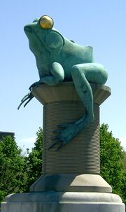
The Frog Bridge in the Willimantic section of Windham.
- Ashford (Town)
- Brooklyn (Town)
- -- East Brooklyn (a village of Brooklyn)
- Canterbury (Town)
- Chaplin (Town)
- Eastford (Town)
- Hampton (Town)
- Killingly (Town)
- -- Danielson (a borough of Killingly)
- Plainfield (Town)
- -- Central Village (a village of Plainfield)
- -- Moosup (a village of Plainfield)
- -- Plainfield Village (a village of Plainfield)
- -- Wauregan (a village of Plainfield)
- Pomfret (Town)
- Putnam (Town)
- -- Putnam District (a village of Putnam)
- Scotland (Town)
- Sterling (Town)
- -- Oneco (a village of Sterling)
- Thompson (Town)
- -- North Grosvenor Dale (a village of Thompson)
- -- Quinebaug (a village of Thompson)
- Windham (Town)
- -- South Windham (a village of Windham)
- -- Willimantic (a village of Windham)
- Woodstock (Town)
- -- South Woodstock (a village of Woodstock)
* Boroughs are incorporated portions of one or more towns with separate borough councils, zoning boards, and borough officials. Villages are named localities, but have no separate corporate existence from the towns they are in.
See also
- National Register of Historic Places listings in Windham County, Connecticut
References
- ^ "CCR: Volume 07, Page 11". http://www.colonialct.uconn.edu/ViewPageByPageNew.cfm?ID=4031&Volume=7&Master=991&Letter=W&v=07&p=11&c=4. Retrieved 2008-06-17.
- ^ Newberry Library -- Connecticut Atlas of Historical County Boundaries
- ^ "Census 2000 U.S. Gazetteer Files: Counties". United States Census. http://www.census.gov/tiger/tms/gazetteer/county2k.txt. Retrieved 2011-02-13.
- ^ http://www.census.gov/population/www/censusdata/cencounts/files/ct190090.txt
- ^ http://factfinder2.census.gov/faces/tableservices/jsf/pages/productview.xhtml?pid=DEC_10_PL_QTPL&prodType=table
- ^ http://mapserver.lib.virginia.edu/
- ^ "American FactFinder". United States Census Bureau. http://factfinder.census.gov. Retrieved 2008-01-31.
External links
- Windham County Sheriff's Department
- National Register of Historic Places listing for New London Co., Connecticut

|
Worcester County, Massachusetts |
| ||
| Tolland County | Providence County, Rhode Island | |||
 Windham County, Connecticut | ||||
| New London County | Kent County, Rhode Island |
| |||||||||||||

| ||||||||||||||||||||
| This page uses content from the English language Wikipedia. The original content was at Windham County, Connecticut. The list of authors can be seen in the page history. As with this Familypedia wiki, the content of Wikipedia is available under the Creative Commons License. |